You are using an out of date browser. It may not display this or other websites correctly.
You should upgrade or use an alternative browser.
You should upgrade or use an alternative browser.
Indian Trace and pointer trees
- Thread starter KY Hiker
- Start date


swiftfan
Sr. Member
Bit of an idea here, but search for the oldest topo maps to see if there were name changes to the areas you’re looking at. Could be someone named those areas later... related place names brings in tourism.. tourism = dollars.. just saying
Rebel - KGC
Gold Member
- Jun 15, 2007
- 21,680
- 14,739
YEPPER! ADDS to the "MYSTERY"... GREAT MARKETING!Bit of an idea here, but search for the oldest topo maps to see if there were name changes to the areas you’re looking at. Could be someone named those areas later... related place names brings in tourism.. tourism = dollars.. just saying

OP
OP
KY Hiker
Bronze Member
- Oct 28, 2014
- 1,537
- 3,220
- Detector(s) used
- Whites
- Primary Interest:
- All Treasure Hunting
- Thread starter
- #44
Bit of an idea here, but search for the oldest topo maps to see if there were name changes to the areas you’re looking at. Could be someone named those areas later... related place names brings in tourism.. tourism = dollars.. just saying
Oldest I can find online is 1952 and the names of the streams and ridges are the same. They just didn't mark the arches back then. Oh, and Daniel Boone N.F. was called Cumberland N.F. back then. Almost all of the streams were named in the late 1700's to early 1800's in this region of KY. Swift Camp Creek and Campton were named around 1800. Campton was called Camp Town first... because of Swift and where he had a camp along that creek.
I think I remember where I heard of Osbourne, it was that presentation video by Prather on his book about Swift in Prestonsburg.
Old article on Swift and this general area with pictures, I think someone else posted this before. It starts on page 419.
https://books.google.com/books?id=a...t&sqi=2#v=onepage&q=swift silver mine&f=false
Last edited:
1320
Silver Member
1320
Silver Member

- Jun 1, 2012
- 5,036
- 7,168
- Detector(s) used
- Garrett ADS-7X, Fisher Two Box M-Scope, Mother Lode Locator, Dowsing Model 20 Electroscope, White's TM808, White's TM900, Inground Scanners
- Primary Interest:
- All Treasure Hunting
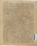
Sweet map, thanks! Looks like only creeks named back then and they haven't changed.
Where is Blackburn Creek? I could not relocate it?
OP
OP
KY Hiker
Bronze Member
- Oct 28, 2014
- 1,537
- 3,220
- Detector(s) used
- Whites
- Primary Interest:
- All Treasure Hunting
- Thread starter
- #49
Where is Blackburn Creek? I could not relocate it?
Its not shown I guess because of its size. It would be the fifth drain on right going North on Spaas Creek. Near where it says Haystack along Red River. I think Boomer posted a picture of the gravesite and carving of Blackburn.

Its amazing to me how the old map shows the head waters of Lower Devil's Creek so close to Rock Bridge Branch/Swift Camp Creek. Where modern day Pine Ridge is. It almost had to be an Indian trace through there, its a natural pathway when you look at a modern topo.
Last edited:
1320
Silver Member
Nice find, thanks 1320!
Postal records?
Robert M. Rennick was an authority on Kentucky place names and spent over thirty years traveling throughout the state documenting the locations and histories of communities, post offices and geographical points of interest.
The Robert M. Rennick Kentucky Place Name Collection consists of maps, oral histories, manuscripts and note cards produced by Rennick during his many years of research.
1320
Silver Member
OP
OP
KY Hiker
Bronze Member
- Oct 28, 2014
- 1,537
- 3,220
- Detector(s) used
- Whites
- Primary Interest:
- All Treasure Hunting
- Thread starter
- #53
This may be of limited use. Looks like Mr. Rennick noted the obvious, nothing earth shattering but perhaps worth a look.
Thanks again 1320! Trace Fork looks interesting East of Campton! Actually if you have the side by side maps just North of this one. Slade and Pomeroyton quadrangles cover the RRGorge propper.
Last edited:
OP
OP
KY Hiker
Bronze Member
- Oct 28, 2014
- 1,537
- 3,220
- Detector(s) used
- Whites
- Primary Interest:
- All Treasure Hunting
- Thread starter
- #54
I came across a description of the Warrior's path through KY. Proctor, near Beattyville was a crossroads of sorts. I'll paste it here.
Warrior's Path
Cherokee - through Kentucky/Ohio
Flat Lick -US25E c7 miles NW of Pineville --Path goes north
Manchester -KY11 -Goose Creek -below Mudlick Station/Flat Creek
Proctor -KY11 (near Beattyville) on South Fork, Kentucky River
West Liberty -US460/KY7 -Morgan Co --Licking River headwaters
Grayson -KY7 -Carter Co -Little Sandy River
Greenup -KY1/2 -Little Sandy River/Ohio River -above Portsmouth
path seems to go north up the Scioto River/Little Scioto
to Sandusky River north of Columbus --to Lake Erie
One branch coming in from Virgina
Big Stone Gap VA -US23
Hazard KY -Kentucky River -Perry Co -KY15
Proctor -KY52
One branch north
Proctor -KY11 north -Lee Co
Mt Sterling -KY11 -Montgomery Co
Sherburne -KY11 -Fleming Co -Licking River//Upper Blue Lick
Maysville -KY11 -Ohio River//Limestone Landing
path continues to Chillicothe OH -Scioto River -north
seems to follow Zane Trace -OH
Last edited:
Curtis
Hero Member
good stuff!
repeating myself, but, I think Swift had followed the last one, someone's diary had said Swift had been seen near
limestone(Maysville).
repeating myself, but, I think Swift had followed the last one, someone's diary had said Swift had been seen near
limestone(Maysville).
OP
OP
KY Hiker
Bronze Member
- Oct 28, 2014
- 1,537
- 3,220
- Detector(s) used
- Whites
- Primary Interest:
- All Treasure Hunting
- Thread starter
- #56
good stuff!
repeating myself, but, I think Swift had followed the last one, someone's diary had said Swift had been seen near
limestone(Maysville).
And the first one takes him right by the waybill area!
Curtis
Hero Member
yes...kind of exciting! There were no doubt other trial/traces, but these really help confirm what they could have followed.
OP
OP
KY Hiker
Bronze Member
- Oct 28, 2014
- 1,537
- 3,220
- Detector(s) used
- Whites
- Primary Interest:
- All Treasure Hunting
- Thread starter
- #58
I will be down in the RRGorge soon looking for more trail trees and possibly getting some grey stone samples collected. I hope to get some more pictures posted as well once I get back.
Anyone been here yet?
Anyone been here yet?
Last edited:
OP
OP
KY Hiker
Bronze Member
- Oct 28, 2014
- 1,537
- 3,220
- Detector(s) used
- Whites
- Primary Interest:
- All Treasure Hunting
- Thread starter
- #59
Well i found two more trail trees in the Rock Bridge area which is about 6-8 miles South of the the first one on Copperas Creek. These were most likely along the same trace. The first one was found right along Rock Bridge Rd about 10ft from the road and point down into a drain that feeds Rock Bridge Fork of Swift Camp Creek. I took these with my cell phone since I was parked on the edge of the road and it was raining.


After finding this tree right along the road it is possible that the road was put in by the forest service where the original trace once was. The next tree was found on a trail that leaves this road and goes to Turtleback Arch. Much of this trail is broad enough to have been a road at one time as well, at least the first half of it near Rock Bridge Road. These were taken with my camera, I thought ahead and brought an umbrella to protect it from the light rain.


That is some type of fungus growing from the end of the pointer. I kicked apart someones fire ring that was 15ft from the base of this tree. Definitely don't want someone taking a hatchet to this tree one day! I'll post a topo map with the locations and pointing directions in the next post.
After finding this tree right along the road it is possible that the road was put in by the forest service where the original trace once was. The next tree was found on a trail that leaves this road and goes to Turtleback Arch. Much of this trail is broad enough to have been a road at one time as well, at least the first half of it near Rock Bridge Road. These were taken with my camera, I thought ahead and brought an umbrella to protect it from the light rain.
That is some type of fungus growing from the end of the pointer. I kicked apart someones fire ring that was 15ft from the base of this tree. Definitely don't want someone taking a hatchet to this tree one day! I'll post a topo map with the locations and pointing directions in the next post.
Last edited:
OP
OP
KY Hiker
Bronze Member
- Oct 28, 2014
- 1,537
- 3,220
- Detector(s) used
- Whites
- Primary Interest:
- All Treasure Hunting
- Thread starter
- #60
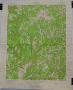
Here is a map with the approx. locations and arrows of pointing direction of the trees I found.

Both point to ways down into either Rock Bridge Fork or Swift Camp Creek. Although the second one could be pointing to Turtleback Arch as well... It would be easier to get a bearing in Winter when the leaves are down.
Both point to ways down into either Rock Bridge Fork or Swift Camp Creek. Although the second one could be pointing to Turtleback Arch as well... It would be easier to get a bearing in Winter when the leaves are down.
Last edited:
Top Member Reactions
-
 2296
2296 -
 1108
1108 -
 1031
1031 -
 909
909 -
 853
853 -
 761
761 -
 761
761 -
 741
741 -
 607
607 -
 508
508 -
 491
491 -
 477
477 -
 442
442 -
 420
420 -
 405
405 -
 403
403 -
O
402
-
 395
395 -
 380
380 -
 379
379
Users who are viewing this thread
Total: 2 (members: 0, guests: 2)


