TrpnBils
Hero Member
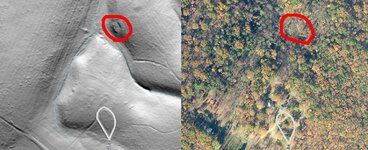
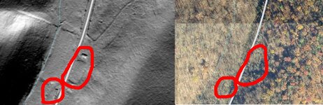
If you're a cellar hole hunter, see if you can find hillshade map overlays for aerial photography. These comparison photos are of two sites I know of near me that have three colonial cellar holes on them which are clearly seen on the hillshade map and completely invisible on the regular satellite image. It pays to dig around a little, and it also really makes old roads stand out well! In the image where there are two cellars, they are each about 4-5 feet deep and stone-lined (I believe the larger rectangle inside the larger circle may have been a garden area or something- there's nothing visible there on the ground). In the image where there is only the one visible, it is literally just a short, 6" high foundation of rocks that is left. You can walk right by it and miss it if you're not looking but it stands out really well (along with the old road which isn't visible at all from the ground) on these overlays.


Attachments
Upvote
0


