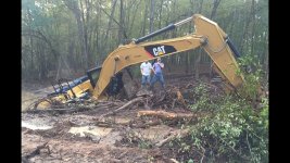
What could it be in the swamp ?

EccentricInTexas

Hero Member
Jan 14, 2013
944
659
Central Texas
Detector(s) used
Minelab Equinox 800 11DD coil 11x15DD coil 6DD coil
Schiebel AN-19/2,
Bounty Hunter Land Ranger Pro,
Bounty Hunter Pioneer 505,
Primary Interest:
All Treasure Hunting
It would make sense if the island was being used as base to make the swamp area into a drydock for ship repairs and stuff. Its also possible they beached a ship there and then took it apart to build the tunnels and pit. If they did this there would be at least a ballast stone pile and possible the bottom of the ship and ballast. Finding a ballast pile they might be able to narrow down where the ship came from assuming there is one there.
 

gazzahk

Bronze Member
Nov 14, 2015
1,717
2,576
Primary Interest:
All Treasure Hunting
I would guess it is something natural. Like the sand they found earlier.

The image they showed is a computer generated graphic based on what their seismic results suggested. It took them six weeks to come up with it from the data from their explosions so who knows what they have done to manipulate the data.

I would guess the raw data did not even remotely look like a ship.

Maybe quick sand and the show will finally finish with Marty slowly sinking into the swamp

maxresdefault.jpg

He is number 7.....

Or it could be this guys lair

be4456da770511057cb914f19040ffa3fd857475r1-825-464v2_uhq.jpg

The last photo of Marty taken....


hand-coming-up-from-the-swamp-554x350.jpg
 

OP
OP
sasquash

sasquash

Sr. Member
Nov 2, 2016
449
425
North of Quebec
Detector(s) used
Computers
Primary Interest:
Other
A burlap croaker sack with lettering above a cross:
de MOLAY BROS
TEMPLAR BRAND
COIR

Hopefully you will post a contemporary quote, not second hand hearsay or assumption, and most importantly, cite the source material origin.
:laughing7:
 

ECS

Banned
Mar 26, 2012
11,639
17,694
Ocala,Florida
Primary Interest:
Other
I, ECS, am the one and only source of the burlap croaker sack quote. :thumbsup:
...not Charles Addison, Michael Haag, Piers Paul Read, Baigent & Leigh, or any of the others who present alternative Templar history as fact- or those that utilize their material as if it were their own research. :laughing7:
 

Last edited:

lokiblossom

Bronze Member
Dec 4, 2014
1,865
1,310
Traverse City, Mi.
Primary Interest:
Relic Hunting
I, ECS, am the one and only source of the burlap croaker sack quote. :thumbsup:
...not Charles Addison, Michael Haag, Piers Paul Read, Baigent & Leigh, or any of the others who present alternative Templar history as fact- or those that utilize their material as if it were their own research. :laughing7:

Again a ridiculous statement about three well respected historians on the Knights Templar Order only used to embellish yourself (I ECS). You can't even explain how any of Addison, Haag or Read's history is in any way considered "alternative", right?

Cheers, Loki
 

Last edited:

burlbark

Full Member
Mar 5, 2011
224
324
Has everyone forgot that there was no swamp until the roadway was built along the ocean to transport the heavy equipment to the sink hole/money pit?

The heavy rains in the area and snow fall cause this man made wet area to turn into a pond every year.........Has everyone forgot?
 

Al D

Bronze Member
Jul 23, 2011
2,066
3,525
Gold canyon AZ
Detector(s) used
DJI Air 2S
Primary Interest:
Cache Hunting
Not entirely on the subject but close enough for me to post it here;
the first land survey of Oak Island occurred around 1756, when the parcels were created for sale. I was looking at a map and was surprised to see one parcel, # 32 was almost entirely swamp, however the map was from 1912.
my question to anyone is this.
how old is the swamp?
why would anyone try to sell swamp land or why even survey it for inclusion in the land parcels for sale?
my premise is this, I wonder if the swamp was created when the money-pit flooded
Is there a map of the original land survey in 1756?
 

Al D

Bronze Member
Jul 23, 2011
2,066
3,525
Gold canyon AZ
Detector(s) used
DJI Air 2S
Primary Interest:
Cache Hunting
Has everyone forgot that there was no swamp until the roadway was built along the ocean to transport the heavy equipment to the sink hole/money pit?

The heavy rains in the area and snow fall cause this man made wet area to turn into a pond every year.........Has everyone forgot?
We must have been posting at the same time, haha
is there a photo or map of the island before the roadway was built?
 

gazzahk

Bronze Member
Nov 14, 2015
1,717
2,576
Primary Interest:
All Treasure Hunting
The old aerial photos have the swamp there before road was built. Dunfeild built the road.

phoca_thumb_l_oak-island-nova-scotia-aerial-july-7-1965.jpg
 

Last edited:

n2mini

Hero Member
Jan 7, 2015
983
514
Triad NC
Primary Interest:
All Treasure Hunting
When surveying land it all has to be included somewhere. Could have just added it to parcels around it of course or just have it as a separate piece that ends up being sold to someone who's land touches it so they can control what happens on it. A land border per say to your neighbors...
 

Robot

Bronze Member
Mar 10, 2014
2,016
1,717
Primary Interest:
Other
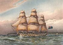
HMS Sterling Castle?

The Sterling Castle was supposedly scuttled at Havana after reportedly suffering numerous hits from Morro's Fortress.

The truth revealed is that the ship avoided its assault...even to having the Ship's Captain charged with Disobeying his given orders.

The reality is it was used as one of the many British Ships to ferry the plundered loot from the Spanish and Jesuits to Oak Island and declared lost.

There in the Swamp...The HMS Sterling Castle...met its demise.

Sterling Castle.jpg
 

ToastedWheatie

Hero Member
Jun 30, 2013
532
759
Hudson Valley, NY
🥇 Banner finds
1
Detector(s) used
800
Infinium
Whites M6
Primary Interest:
Relic Hunting
What has always jumped out at me was the depth that would have been required to scuttle a ship. If it was originally two separate islands, and they put a ship between the two and sank it, and then they ended to create the swamp then the depth between those islands would have had to been deeper than would have naturally occurred. Doesn't make sense. Those two islands would have been too close together to have a 20-30 foot deep Channel.
 

burlbark

Full Member
Mar 5, 2011
224
324
The old aerial photos have the swamp there before road was built. Dunfeild built the road.

View attachment 1713455

Yep and it all but dries up in the summer time.

The roadway that they put in place keeps it marshy and wet for much longer. Wet areas are common on almost all the islands in the area but his road is the main cause for the retention and ponding affect.

When Nolan refused to allow heavy equipment to be rolled across his land they went back and rebuilt the road. The roadway is actually present in your picture but had some extensive reworking late 50's, if you didnt know where to look or how to see it you would not know it from your picture.
 

Attachments

  • oak island roadway.jpg
    oak island roadway.jpg
    93.9 KB · Views: 213

n2mini

Hero Member
Jan 7, 2015
983
514
Triad NC
Primary Interest:
All Treasure Hunting
swamp.jpg

Here is something they'd like to find in there. Not old enough but you get the idea...
 

Top Member Reactions

Users who are viewing this thread

Top