Jason in Enid
Gold Member
- Oct 10, 2009
- 9,593
- 9,229
- Primary Interest:
- All Treasure Hunting
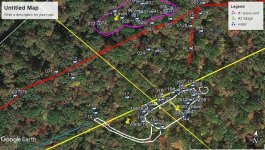
This is the layout of the Paleo Indian Stonehenge Site and there is more than this. I will post more info about this map today.
Hahaha! One things for sure, you have one hell of an imagination!


 that's all I need now. I been there 3 months and did not see any but I am sure they saw me


.jpg")