Pennsylvania Ghost Towns

jeff of pa

Super Moderator
Staff member
Dec 19, 2003
85,844
59,630
🥇 Banner finds
1
🏆 Honorable Mentions:
1
Primary Interest:
All Treasure Hunting
soopacee said:
http://home.comcast.net/~StAnthonyWilderness/picpage.htm


^^im very interested in Rausch Gap....anyone have info on it, or know where it "was" located??

Rausch Gap was located on the top of gold Mine mountain & back the old
S&S Rail Road. it is in Lebanon County.

The land is State game land and the only time
you can Drive to it is in the fall
for one day (Fall Foilage Tour) when they open it
up for People to drive it.

There are Ghost towns all along
the S&S Between Dauphin in Dauphin County
and Gold Mine road.

Including Cold Springs which is a Ghost resort.

When Rausch Gap Disbanded,
some of the homes were taken by rail to
a new site in Tremont Township
and became known as Rausch Creek.

When Interste 81 was built in the 70's
Rausch Creek was Torn down
 

soopacee

Full Member
Apr 27, 2008
178
61
Pottsville, PA
Detector(s) used
Garrett Ace 400, Nel Tornando,
Garrett Carrot PinPointer
Primary Interest:
All Treasure Hunting
jeff of pa said:
soopacee said:
http://home.comcast.net/~StAnthonyWilderness/picpage.htm


^^im very interested in Rausch Gap....anyone have info on it, or know where it "was" located??

Rausch Gap was located on the top of gold Mine mountain & back the old
S&S Rail Road. it is in Lebanon County.

The land is State game land and the only time
you can Drive to it is in the fall
for one day (Fall Foilage Tour) when they open it
up for People to drive it.

There are Ghost towns all along
the S&S Between Dauphin in Dauphin County
and Gold Mine road.

Including Cold Springs which is a Ghost resort.

When Rausch Gap Disbanded,
some of the homes were taken by rail to
a new site in Tremont Township
and became known as Rausch Creek.

When Interste 81 was built in the 70's
Rausch Creek was Torn down

damn state game land >:(
 

Vanillacricket

Jr. Member
Jan 28, 2009
68
0
Annville
Detector(s) used
Cheap One
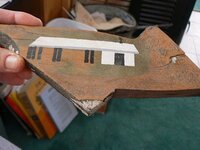
Stony creek is an awesome place though watch the rattlers. Theres an old cemetary by the rr bridge. Really cute. Also there are indian caves north and some sites in yellow springs. Heres a piece of the original train station in cold springs. I painted the building on it.
 

Attachments

  • jsw_p1050703.jpg
    jsw_p1050703.jpg
    21.3 KB · Views: 760

jeff of pa

Super Moderator
Staff member
Dec 19, 2003
85,844
59,630
🥇 Banner finds
1
🏆 Honorable Mentions:
1
Primary Interest:
All Treasure Hunting
Vanillacricket said:
Stony creek is an awesome place though watch the rattlers. Theres an old cemetary by the rr bridge. Really cute. Also there are indian caves north and some sites in yellow springs. Heres a piece of the original train station in cold springs. I painted the building on it.

first time I was up there the Station was still standing.

On Stoney Valley

On May 2 officials from the National Guard at Indiantown Gap announced to the local media that they were, at least temporarily, ceasing the construction of the Multi Purpose Training Range (MPTR) that would have necessitated use of 900 acres in Stony Creek, State Gameland 211. Thanks to all of you who worked so hard to save Stony Valley once again. The funds intended for the MPTR will be used for other projects by the Pennsylvania National Guard.

Although this appears to be good news, the National Guard is completing the Environmental Assessment for the project and considers the Use Agreement with the PA Game Commission to be a viable document. We are working to "beef-up" the legislation that designates Stony Creek as a Pennsylvania Wild & Scenic River to better protect the wilderness.

http://www.savestonyvalley.com/
 

jeff of pa

Super Moderator
Staff member
Dec 19, 2003
85,844
59,630
🥇 Banner finds
1
🏆 Honorable Mentions:
1
Primary Interest:
All Treasure Hunting
Vanillacricket said:
sadly its eventual. There is a really nice standing of holly trees in yellow springs

There is also a supposed Cache Buried South of the Tracks at one of the Home sites along the
old stage road.

I Met a guy there Who said it is Definately there & He's still trying to find it.
 

jeff of pa

Super Moderator
Staff member
Dec 19, 2003
85,844
59,630
🥇 Banner finds
1
🏆 Honorable Mentions:
1
Primary Interest:
All Treasure Hunting
Vanillacricket said:
Hey Jeff do you happen to have any photos of high bridge?

Nope

Believe it or not that is the one place I have never been.

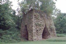
this is the Iron Furnace just south of it.

!!SD012009.jpg
 

jeff of pa

Super Moderator
Staff member
Dec 19, 2003
85,844
59,630
🥇 Banner finds
1
🏆 Honorable Mentions:
1
Primary Interest:
All Treasure Hunting
I can't even find any pics of the old one online yet.
 

jeff of pa

Super Moderator
Staff member
Dec 19, 2003
85,844
59,630
🥇 Banner finds
1
🏆 Honorable Mentions:
1
Primary Interest:
All Treasure Hunting
Been to the high Rocks (Boxcar rocks) on several occasions
 

jeff of pa

Super Moderator
Staff member
Dec 19, 2003
85,844
59,630
🥇 Banner finds
1
🏆 Honorable Mentions:
1
Primary Interest:
All Treasure Hunting
by the way

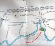
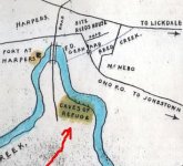
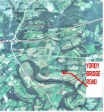
Know anything on the "CAVES OF REFUGE" from the 1750's ?
I believe they are near the bridge on Yordy bridge road.

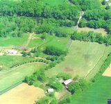
Harpers Fort was in the area of the School

Back from Harpers Tavern

!!!1.jpg
 

Vanillacricket

Jr. Member
Jan 28, 2009
68
0
Annville
Detector(s) used
Cheap One
Those caves are on my list this spring. going to out the one at harpers and hummelstown. Artifact hunting up there is good
 

jeff of pa

Super Moderator
Staff member
Dec 19, 2003
85,844
59,630
🥇 Banner finds
1
🏆 Honorable Mentions:
1
Primary Interest:
All Treasure Hunting
I'v been Trying for awhile now on the caves of Refuge,
Although They are Well known in the area
so far Nobody has been able to tell me where exactly they are.

I havn't asked anyone who Lives right there at the Bridge yet though.
 

davew0710

Sr. Member
Oct 3, 2008
392
0
Western Pennsylvania
Detector(s) used
E Trac
If you guys are up for a hunt,let me know.I can fill you in on it


[/quote]


Sounds good to me. Let me know where and when. Where in Ohio are you?
 

jeff of pa

Super Moderator
Staff member
Dec 19, 2003
85,844
59,630
🥇 Banner finds
1
🏆 Honorable Mentions:
1
Primary Interest:
All Treasure Hunting
More of my research on the Caves of Refuge.

!!!index.jpg

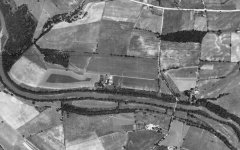
Looks like thay cound be Left or Right of
Yourdys Bridge.
Or both. but most likely left (West)

The Bank isn't High along the creek though
So they could be Under water now

!!CAVES.jpg

!!!yordys.jpg


1937

!!banon_080337_ahn_25_67.jpg
 

jeff of pa

Super Moderator
Staff member
Dec 19, 2003
85,844
59,630
🥇 Banner finds
1
🏆 Honorable Mentions:
1
Primary Interest:
All Treasure Hunting
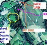
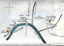
On the Fort at Harpers. Many seem to Think The fort was where the
Sign & The B&B IS

!!!HarpersFort.jpg

But if you look at the Measurements on the Map

!!!Harpers.jpg


Unless the Original Bridge was alot fruther East then where I marked the
Remains.


I Think Harpers Fort was Behind the School.

Of course that ground has been Damaged when they put the school in

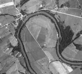
1937 ariel

!!lebanon_082837_ahn_29_36.jpg
 

planebill

Tenderfoot
Mar 18, 2007
8
0
Jeff

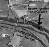
I tracked the area you have mapped about a year ago. I did find 1 very small 'cave'. It had an opening about 3' high (or less) and went back maybe 6'. At the back of the cave was an approximately 6' deep hole that had an accumulation of leaves, an old shovel and a short step ladder in it. The ground around the entrance is rock with a thin layer of dirt. This did not strike me as a place for 'refuge' from rampaging natives. To the west of the bridge there isn't any real bluff. To the south of the Swatty where the old Union Canal tow path is marked is all bottom land. The bluff does continue further east but I didn't get any further than 500 yards or so east of the little cave. Without foliage the little cave is visible from the tow path and looks more promising than it is.

Bill

verysmallcave.jpg
 

Top Member Reactions

Users who are viewing this thread

Top