Welcome guest, is this your first visit?
Member
Discoveries
 
Results 1 to 18 of 18
  1. #1
    Cappy Z.

    La Roque? on old map

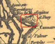
    Just curious what these four crosses might mean on this old map?
    Attached Thumbnails Attached Thumbnails La Roque? on old map-monastery.jpg  

  2. #2
    nl
    Sep 2010
    439
    4 times

    Re: La Roque? on old map

    Cappy those are reefs or sandbanks sticking out of the water . Cornelius

  3. #3
    us
    Oct 2007
    Pascagoula Ms.
    minelab exp.
    2,017
    1 times

    Re: La Roque? on old map

    In the Occitan language the word Roque is said Ròca. In a book of Gascon toponymy written by Benedict and Jean-Jacques Fénié it is said that the word Ròca not only designate a rock or a boulder but also a rocky heights fortified or not. Documents of the time written in Gascon call our ancestor de la Roca meanwhile in Latin we speak of Ruppe which mean Rock.My guess is good place to dump rocks & marked on the maps so they can find them if needed for the ships after unloading cargo,for the journey home.

  4. #4
    Cappy Z.

    Re: La Roque? on old map

    Quote Originally Posted by cornelis 816
    Cappy those are reefs or sandbanks sticking out of the water . Cornelius
    Thanks Cornelius.

  5. #5
    Cappy Z.

    Re: La Roque? on old map

    Quote Originally Posted by RELICDUDE07
    In the Occitan language the word Roque is said Ròca. In a book of Gascon toponymy written by Benedict and Jean-Jacques Fénié it is said that the word Ròca not only designate a rock or a boulder but also a rocky heights fortified or not. Documents of the time written in Gascon call our ancestor de la Roca meanwhile in Latin we speak of Ruppe which mean Rock.My guess is good place to dump rocks & marked on the maps so they can find them if needed for the ships after unloading cargo,for the journey home.
    Maybe ballast intentionally or unintentionally placed...

  6. #6
    nl
    Sep 2010
    439
    4 times

    Re: La Roque? on old map

    A ballast pile would be closer to the port of unloading . Otherwise travelling to the ballast would be to dangerous . An unballasted ship would be open to turning over in a mild wind . So no use picking up ballast so far out of the coast line . No , I think that it is a warning to ships that there are rocks or banks in that area , They should not sail close to that area . One can see these marks on many a map . They are always used as a reminder of trouble in the area . Cornelius

  7. #7
    Cappy Z.

    Re: La Roque? on old map

    Quote Originally Posted by cornelis 816
    A ballast pile would be closer to the port of unloading . Otherwise travelling to the ballast would be to dangerous . An unballasted ship would be open to turning over in a mild wind . So no use picking up ballast so far out of the coast line . No , I think that it is a warning to ships that there are rocks or banks in that area , They should not sail close to that area . One can see these marks on many a map . They are always used as a reminder of trouble in the area . Cornelius
    Thanks Cornelius. Maybe someone has been diving there in the past?

  8. #8
    us
    discovering & preserving our past for future generations

    Dec 2004
    Jupiter, Florida
    Aquapulse, DetectorPro Headhunter
    1,993
    1 times
    Shipwrecks

    Re: La Roque? on old map

    That area appears to be in the Canaveral National Seashore.

    If you want to read about someone who has been "diving" there in the past, read this: (begin on page 2 where it starts "The United States was however, successful in it's application of the Antiquities Act in the Lathrop case.")

    http://docs.google.com/viewer?a=v&q=...Zi_WmW6eNe6Z7w

  9. #9
    Cappy Z.

    Re: La Roque? on old map

    Thanks Mad4wrecks.
    I read it.
    So, the corrupt Florida and corrupt Federal govt claims jurisdiction for 0-200 miles off the cost.
    Said jurisdiction allows them to 'protect' sea grass and deny non-governmental salvages from 'historic' underwater sites. The 4 crosses might in fact indicate an area loaded with treasures. But essentially the area is off limits by Big Brother government. Interesting.

  10. #10

    Feb 2007
    241

    Re: La Roque? on old map

    Cappy Z:
    It would appear that in your old map "La Roque" is French for "the rock" as in Spanish its "la roca".
    Now if your map said "el San Roque" or even "el Roque" and if it was a bit more south say close to Central America or Serranilla, well that would be a valuable map.
    Panfilo

  11. #11
    Cappy Z.

    Re: La Roque? on old map

    Quote Originally Posted by Panfilo
    Cappy Z:
    It would appear that in your old map "La Roque" is French for "the rock" as in Spanish its "la roca".
    Now if your map said "el San Roque" or even "el Roque" and if it was a bit more south say close to Central America or Serranilla, well that would be a valuable map.
    Panfilo
    lol Like you're leaving it at that! I don't think so. More..more..more..

  12. #12

    Feb 2007
    241

    Re: La Roque? on old map

    I was refering somewhat sarcastically to the Capitana San Roque, 1605, Luis Fernandez de Cordoba fleet. If you're not very familiar with this galleon I recommend you buy a copy of Claudio Bonifacio's excellent new book.
    Panfilo

  13. #13
    Cappy Z.

    Re: La Roque? on old map

    Quote Originally Posted by Panfilo
    I was refering somewhat sarcastically to the Capitana San Roque, 1605, Luis Fernandez de Cordoba fleet. If you're not very familiar with this galleon I recommend you buy a copy of Claudio Bonifacio's excellent new book.
    Panfilo

  14. #14

    Feb 2007
    U.S.
    Garrett, Minelab, Aqua-Pulse
    537
    6 times

    Re: La Roque? on old map

    Those would be the "Bulls" and/or Hetzel Shoals, southwest of which, Hawkins reported seeing the sunken masts of the Mexican plate fleet (of Juan Menendez) when visiting the French at Jacksonville, circa 1564.

    Below is an anonymous map dated 1568 of Spanish origin from the Indies Archives showing similar notation, sans any label.
    Attached Thumbnails Attached Thumbnails La Roque? on old map-1528anon.jpg  

  15. #15
    Cappy Z.

    Re: La Roque? on old map

    Thanks signumops,

    It appears to me..that the crude map had a name attached to each area at the mouth of a river. It almost appears as if they moved down the coast and stopped at each rivers mouth and probably took a small craft to investigate. Then moved on. Guessing, maybe the rivers allowed for access to fresh water, timber, and food.

  16. #16

    Feb 2007
    U.S.
    Garrett, Minelab, Aqua-Pulse
    537
    6 times

    Re: La Roque? on old map

    Actually, at that time, most of the maps done by the French and Spanish of the eastern coast of America were drawn with an emphasis on military/naval strategy. They were interested in those points where it would be beneficial to construct outposts capable of handling larger vessels, or where access to the fabled northwest passage might be located. The Spaniards were terrified that there might be a nearby naval establishment that could interrupt the flotas passing offshore. Were it not for that alone, I am sure that St. Augustine would not exist. Menendez took over the Indian village of Seloy as his base, knowing that the French fort to the north was already occuppied. Why he stayed at the location we know as St. Augustine is a mystery to me as the location of Fort Caroline at Jacksonville was probably a much better all-round locale, found on higher ground as necessary, and with a better anchorage. That was also the gateway to the interior of Florida as far as present-day Sanford.

    However, the Indians in the vicinity of Jacksonville were already hostile to the Spanish, and there were more Indians in that area than the vicinity of St. Augustine from what I can tell in my investigations to this point.

    I am going to publish a re-print of Doug Armstrong's "French Castaways at Old Cape Canaveral" in several weeks. Read that! It's a real eye opener!

  17. #17
    Cappy Z.

    Re: La Roque? on old map

    Thanks for the great info signumops,

    I would love to read that Doug Armstrong's "French Castaways at Old Cape Canaveral" when you post it.

    I've often wondered if you can access old newspapers throughout Florida on microfiche like they used to do in Cleveland at the downtown Library? I'm certain people have found artifacts for years and probably had small write ups in local small town newspapers.

    HH

  18. #18
    us
    Oct 2007
    Pascagoula Ms.
    minelab exp.
    2,017
    1 times

    Re: LDona Roque? on old map

    Don't forget they had another Canaveral on the Gulf side in early 16th century, if the wrecks don't show up in that spot!
    Attached Images Attached Images  


Sponsors

Posting Permissions

  • You may not post new threads
  • You may not post replies
  • You may not post attachments
  • You may not edit your posts
  •  
Powered by vBadvanced CMPS v4.1.3