Steves Glory Hole revisited

signumops

Hero Member
Feb 28, 2007
756
226
U.S.
Detector(s) used
Garrett, Minelab, Aqua-Pulse
Primary Interest:
All Treasure Hunting
Steve's Glory Hole revisited

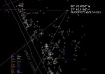
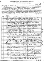
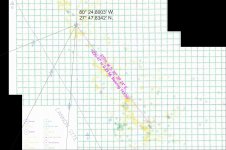
Steve Shouppe's boat stumbled onto a hole with escudos and reales in August of 92. When Tommy Gore and I produced "The Rainbow Chasers In The Great Florida Treasure Hunt", we added Steve's logsheet for that discovery on page 235. Got to looking at it the other day and decided to establish the fix for that hole using MagTrakR. Just for amusement. If the sheet is legit, this would have been at the very north end of the Corrigan's Patch wreck, in the vicinity of the Green Cabin.
 

Attachments

  • GOLDHOLEMAP.jpg
    GOLDHOLEMAP.jpg
    130.1 KB · Views: 310
  • shoupegold.jpg
    shoupegold.jpg
    1.3 MB · Views: 4,459

mad4wrecks

Bronze Member
Dec 20, 2004
2,263
107
Detector(s) used
Aquapulse, DetectorPro Headhunter, Fisher F75
Primary Interest:
Shipwrecks
Terry, nice work.

It's interesting because as you see, the name of the wrecksite Shouppe used was the "Lucky 7" which I was told was named for the 7 cannons discovered in the area. This site was later re-named the Cannon Wreck, which is actually a bit north of the Green Cabin, off the south end of Treasure Shores park.

The "pig iron" wreck is also just outside of that area, in a little deeper water.

Wasn't this also the general area where Mo found the Colt pistols?

Tom
 

Last edited:

theseeker

Sr. Member
Mar 4, 2009
345
139
Detector(s) used
White's Surf PI Pro Dual Field/Minelab Sovereign Elite/Goldbug II/Goldbug Pro
Am I reading the log sheet incorrectly under the written words 39 Doubloons where he writes D-E 23 01 and E-F 40 20? Are those partial Lat Long notations?
 

Au_Dreamers

Hero Member
Dec 15, 2010
988
669
back on the 1715!!
Primary Interest:
All Treasure Hunting
Those are beach marker readings from back when we shot beach markers with a sextant to get your boat location-prior to 1997 -pre DGPS days.
 

Denniss

Full Member
Jan 7, 2011
207
229
Fort Pierce, FL
Detector(s) used
Fisher CZ-21, Fisher Impulse, Gold Bug II
Primary Interest:
Shipwrecks
That's impressive software, combined with your data, you have a heck of a tool. I like the way you can take the old bearings and arrive at a Lat/Lon position.
 

OP
OP
signumops

signumops

Hero Member
Feb 28, 2007
756
226
U.S.
Detector(s) used
Garrett, Minelab, Aqua-Pulse
Primary Interest:
All Treasure Hunting
I have been on a mapping job for the last week and could not get to answer a question that was posted to me privately regarding the location of the glory hole at Green Cabin rather than at the Cannon site, where the legend has the original location. It well may have been there at the Cannon site as there were the appropriately designated markers (D, E and F). This morning I plotted the same bearings against those markers in the Fisher base map and arrived at a new fix, as seen in the attached illustration. However, if you look at the attachment, you will see that it was an odd fix using a minor angle that would be far less accurate than a bearing using the G marker instead of the D marker. Perhaps the G marker was missing at the time. I used the D, E and F markers at Green Cabin originally because they give a better range on the sextant, as I would have chosen myself, instead of the D, E and F markers at the Cannon site. I would have to presume that Shouppe did not use the G marker because he could not see it, or, it was missing.

If you examine the worksheet from my original post, you see that the start position was "200 yards" from shore (maybe 700 yards, but I seriously doubt it). In the first position I posted at the Green Cabin, the hole is 800 feet from shore, typically a useful recovery depth for these wrecks. In the attached illustration, the position is about 400 feet from shore, also a reasonable distance for the scatter patterns of the wrecks on the Treasure Coast.

I've spoken to a diver who 'claimed' he was aboard when this discovery was made. His name is not on the log sheet. He claimed that the position was intentionally phoney. The log sheet states the group was working on the Lucky 7 site... what does that mean? Probably just as Tom indicated, which would be the Cannon site.

Whatever the case, I never worked the Cannon site myself, so I really have no idea of what the story may be. Best of luck!
 

Attachments

  • GOLDHOLEMAPatCannonSite.jpg
    GOLDHOLEMAPatCannonSite.jpg
    44.3 KB · Views: 374
Last edited:
OP
OP
signumops

signumops

Hero Member
Feb 28, 2007
756
226
U.S.
Detector(s) used
Garrett, Minelab, Aqua-Pulse
Primary Interest:
All Treasure Hunting
Here's a shot of the spot with the Fisher Chart underneath. I did not have the digital AutoCAD file to use here, but this is a scanned copy of a printed chart I got from Bill. The usual white holes for EMPTY are actually yellow in this illustration because of the scanner software.

The glory hole is about 1200 feet further up the shoreline from the actual cannon collection.
 

Attachments

  • GOLDHOLEMAPonPaperChart.jpg
    GOLDHOLEMAPonPaperChart.jpg
    314.2 KB · Views: 476
OP
OP
signumops

signumops

Hero Member
Feb 28, 2007
756
226
U.S.
Detector(s) used
Garrett, Minelab, Aqua-Pulse
Primary Interest:
All Treasure Hunting
Tom mentioned the guns found at the Cannon wreck... here's the story. Joel Ruth sent me this.
 

Attachments

  • 1715 Fleet 003.jpg
    1715 Fleet 003.jpg
    151.9 KB · Views: 219

Top Member Reactions

Users who are viewing this thread

Top