Wreck Image via LIDAR at Klondike Beach

signumops

Hero Member
Feb 28, 2007
756
226
U.S.
Detector(s) used
Garrett, Minelab, Aqua-Pulse
Primary Interest:
All Treasure Hunting
You can say you saw it on Treasurenet first.
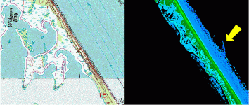
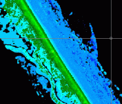
The attached image is a comparitive view of the shoreline Near Pardon Hammock on Klondike Beach. On the left is the USGS view and on the right is the LIDAR view of the same area. This is 2004 LIDAR from NOAA. Klondike Beach is within the Canaveral National Seashore.

The LIDAR is a swath about 1000 feet wide. You can obtain the data yourself directly from NOAA. If you are familiar with the area, you know that the bottom is almost entirely sand for miles. The anomaly I have highlighted here is almost certainly a hull.
You won't be able to find out though, because the NPS won't let you dig it up. And they won't dig it up either. But, you might just walk by there after a Noreaster or hurricane and find 'something' of interest. Who knows?

I did not put a scale on the image, but, the anomaly is about 150 feet long, plowed into the shore from the north to the south I believe.

If somebody else has LIDAR covering this area from a different year, I would like to see it, just to find out if the anomaly exists repeatedly. After all, no harm can be done because nobody can excavate it.

My next question is "how can the Federal government use remote sensing along the shoreline of Florida without acquiring a permit from the Bureau of Archaeological Resources ?" (LOL)
 

Attachments

  • VecadImage.gif
    VecadImage.gif
    103.9 KB · Views: 1,375

djabend

Hero Member
Dec 12, 2006
766
69
Cicero, NY
Detector(s) used
White's DFX 300 Sunray DX-1 probe/ XLT Sunray XL-1 probe
I pasted the LIDAR image into Google Earth and the anomaly is almost 500ft wide and just the side that was visible is over 700ft long. It is my opinion that this is too large and it is most likely a large sandbar.
too large.jpg

HH,
Donny
 

OP
OP
signumops

signumops

Hero Member
Feb 28, 2007
756
226
U.S.
Detector(s) used
Garrett, Minelab, Aqua-Pulse
Primary Interest:
All Treasure Hunting
Another sensor devotee! Good work! You might be right, but, only repeated observations over time would tell for sure. I would have posted the entire swath, but it is too big to upload on the forum. There's really no reason for a sandbar to be here, but you are right about the scale. If you look at the zoomed attachment, you can see that it appears to be in sections, and there is an obvious small pile elevation to the NW. The elevations are in 5 foot increments, but the breaklines on the quad sheet don't indicate this much topography here.
 

Attachments

  • VecadImagezoomed.gif
    VecadImagezoomed.gif
    60.7 KB · Views: 1,849

stevemc

Bronze Member
Feb 12, 2005
2,121
277
Sarasota, FL
Detector(s) used
Whites Surfmaster PI Pro and Whites Surfmaster PI, Minelab Excal NY blue sword. 2 White's Dual field pi, Garrett sea hunter pi II (but don't use it for obvious reasons) 5' x 3 1/2' coil underwater Pi
Primary Interest:
Shipwrecks
I also feel that this is a very large area. There may be something there. It might be a coquina reef, or a sandbar. Or it could be......! Do they let you snorkle there? If so, maybe someone(me) could check it out.
 

stevemc

Bronze Member
Feb 12, 2005
2,121
277
Sarasota, FL
Detector(s) used
Whites Surfmaster PI Pro and Whites Surfmaster PI, Minelab Excal NY blue sword. 2 White's Dual field pi, Garrett sea hunter pi II (but don't use it for obvious reasons) 5' x 3 1/2' coil underwater Pi
Primary Interest:
Shipwrecks
Looks like a very long walk to that area from the last parking area. From Google earth, I can only see sand. No dark area showing, which would indicate a reef or something other than sand. It may be an anomoly, or a glitch in the recording, but it is worth looking at. How many miles to the last parking area?
 

OP
OP
signumops

signumops

Hero Member
Feb 28, 2007
756
226
U.S.
Detector(s) used
Garrett, Minelab, Aqua-Pulse
Primary Interest:
All Treasure Hunting
It's about 4 miles north of the last northern lot on Playalinda... Camera Pad AZ10. There is a dogleg in the jeep trail at this point, behind the dune.

80 degrees 42 minutes 28.70 seconds West
28 degrees 45 minutes 12.47 seconds North

You can snorkel here, but you have to get a pass from the front gate to walk along the beach north of AZ10... or that's the official story anyway.
 

mad4wrecks

Bronze Member
Dec 20, 2004
2,263
107
Detector(s) used
Aquapulse, DetectorPro Headhunter, Fisher F75
Primary Interest:
Shipwrecks
It very well could be a sandbar, a sandbar that piled up around the ballast pile or structure of a shipwreck.
 

stevemc

Bronze Member
Feb 12, 2005
2,121
277
Sarasota, FL
Detector(s) used
Whites Surfmaster PI Pro and Whites Surfmaster PI, Minelab Excal NY blue sword. 2 White's Dual field pi, Garrett sea hunter pi II (but don't use it for obvious reasons) 5' x 3 1/2' coil underwater Pi
Primary Interest:
Shipwrecks
I was thinking the same thing. I know that there are some wrecks in the area, and they are off limits to salvage, boats and any taking. Might be interesting to snorkle in the area, but its a long drive and walk to find out its nothing. Or a long walk to find out it is something great.
 

FISHEYE

Bronze Member
Feb 27, 2004
2,333
400
lake mary florida
Detector(s) used
Chasing Dory ROV,Swellpro Splash 2 pro waterproof drone,Swellpro Spry+ wa,Wesmar SHD700SS Side Scan Sonar,U/W Mac 1 Turbo Aquasound by American Electronics,Fisher 1280x,Aquasound UW md,Aqua pulse AQ1B
Primary Interest:
All Treasure Hunting
You guys are right,there is a wreck there.but you are roughly 39 years too late.the wreck was worked in 1968-69 by The New Channel Historical Survey Group.for the full story and lots of pics plus lidar info,check out the links.you can thank terry armstrong,its his site,he also worked with them and the real 8 group.that lidar info is old stuff,i checked out all thier shots several years ago.im sure you can snorkle there maybe even scuba.its a a long walk with equipment.cant use a MD there.still might find something hand fanning the bottom.

http://www.pixlbndr.com/wrecker/andrewspics.htm

http://www.pixlbndr.com/wrecker/
 

Attachments

  • jellypot1.jpg
    jellypot1.jpg
    37.5 KB · Views: 601

stevemc

Bronze Member
Feb 12, 2005
2,121
277
Sarasota, FL
Detector(s) used
Whites Surfmaster PI Pro and Whites Surfmaster PI, Minelab Excal NY blue sword. 2 White's Dual field pi, Garrett sea hunter pi II (but don't use it for obvious reasons) 5' x 3 1/2' coil underwater Pi
Primary Interest:
Shipwrecks
Great site, great pics, Thanks. There were some names that bring back memories.
 

Top Member Reactions

Users who are viewing this thread

Top