Welcome guest, is this your first visit?
Member
Discoveries
 
Results 1 to 9 of 9
  1. #1
    ca
    Nov 2008
    Edmonton Alberta
    256

    Peralta Stone Maps

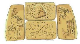
    While studying the Peralta stones and a favored internet site, I Found how to read the stones.
    So far I know of the location of the Santa Fe church treasure, the priest Map mine and most of the heart map mines. If you want to know how to read them, All I will say is the you need to know "The lay of the land" and "The Starting Point". Once you know that, then the rest reveals itself.

    What I need now, is to know what I'm able to do with this info,to insure that i receive something for my effort. Can anyone tell me, or help me out?
    Attached Thumbnails Attached Thumbnails Peralta Stone Maps-peralta_stone_map.jpg  
    David.W.Muise.

  2. #2
    us
    Apr 2006
    minelab 3500
    8

    Re: Peralta Stone Maps

    I would be interested in where on the maps do you concider the starting point to be?

  3. #3
    ca
    Nov 2008
    Edmonton Alberta
    256

    Re: Peralta Stone Maps

    Here it the Starting point for "priest and Horse" stone maps.

    For the "Priest" Map, the starting is at Weaver's Needle, the best way to see the markers is by looking at the superstion mountains through Google Earth.
    For the "Horse" Map, find Brown's Cabin, from there go up to the top of the closest peak and look south, On the cliff (Horse Mesa) that is just across the river, you will see the "Horse", mark the point just above where the neck is and go to that point, Then look North back at the peak you were on and to the right of that, in the valley, you will see the "5" and the four points around it. Now look down near the River, the first row of hills will have an horizone that looks just like the line just below the "5", The outlines will match. Now that you see this, you can see where the mines are located.
    The Santa Fe Church Treasure is shown in this map as well if you know how to read it.

    If you do find the mines and recover a sample, or, if anything is gained from this info, Please don't forget me. I do something for you, it would be nice if you return the favor, thats all i ask. thanks, good luck and be careful.
    David.W.Muise.

  4. #4
    us
    Mar 2007
    southwest colorado
    259

    Re: Peralta Stone Maps

    Quinan Bear,
    Do you have an opinion as to who made the stone maps?
    Bill

  5. #5
    ca
    Nov 2008
    Edmonton Alberta
    256

    Re: Peralta Stone Maps

    I am not sure, but if I had to guess, I would have to say the Jesuits were the ones that made the maps. I say this, because they were the ones that used large land formations as markers, the reason was that large formations would last for a very long time and it would take Alot to deface those formations. I know how to read ALL the peralta maps and the mines that they show.
    If you have other Maps or discriptions of lacations that you would like for me to decypher for you just sent me an email and ill try to help you out.
    I know the location of the Tumacacori Mission treasure as well, but cannot find someone that will partner up with me, this treasure is Very large. Only if there is a legal contract signed by the two of us, will I devulge my info.
    David.W.Muise.

  6. #6
    us
    Aug 2010
    91

    Re: Peralta Stone Maps

    Pretty sure that "stone map" was already solved, turns out the "cache" is buried in a certain mountain with a monument at the top.
    and there being a certain line of "beehives" that point to the mountain.
    ...but what do I know?
    Protect our Second Amendment Rights!!
    The "bad guys" don't want us to have guns to defend ourselves!!!

  7. #7
    us
    Sep 2010
    West
    18

    Re: Peralta Stone Maps

    Quote Originally Posted by Quinan Bear
    All I will say is the you need to know "The lay of the land" and "The Starting Point". Once you know that, then the rest reveals itself.

    What I need now, is to know what I'm able to do with this info,to insure that i receive something for my effort. Can anyone tell me, or help me out?
    Sure, I can help you out, and I couldn't agree more, but something tells me your "starting point" may not be correct.
    A careful view of the river systems in the area of the supposed map site, places this "Starting Point" some 9 miles NE at approx 52 degrees of Florence and the end location is not in the Superstitions at all. If only the 3 men from Utah knew this prior to running off half cocked not knowing they could drive to it. Understanding that the Peralta's did not have access to flying machines, who ever etched the map did a pretty fair job and it isn't as cryptic as many have made it out to be, they were people just like us. But what really is going to erk a few is discovering that the end location indicated on the map has been long mined out and historically, what has been brought out of there would fully constitute the time and effort that was put into the stone maps.

    So unless you have really thought this through, I would sit back and possably evaluate it all again, and again.
    Take the stories with a grain of salt and apply some common sense. Save yourself a ton of time and money, because it will swallow you up. Make sure that what you have is factual, plausible and makes sense and then question it all again.


    Just my two cents.
    Nice Site Marc, My compliments.
    What? No spell checker?

    Tuscoro

  8. #8
    cx
    Jan 2006
    SoCal
    Modded SD2000 / Excalibur 1000 / XTerra70 / Fisher Gemini / Mineoro DC2007HAHA :-)
    3,605
    3 times

    Re: Peralta Stone Maps

    Tuscoro,

    Welcome to TNet.

    I will say that there has been ALMOST as many people who have deciphered the Stone maps as there have been that have found the Dutchman's Lost Mine (Jacob Waltz was never lost).

    That said, an interesting comment by Tom Glover in his book on the DLM is that everybody that has deciphered the stones has been led to something. Almost every time the trail ended at an old mineshaft, big heart, cave, etc. Sometimes not even necessarily in the Superstitions. It's almost paranormal. HAHAHA

    One of the biggest problems with many people when it comes to the Stone Maps is that they stretch or twist them to fit their interpretation.

    Now, are they heavily encoded or not? Who knows? Since there is no provenance for them, we don't have any idea when they were made! 1767? 1847? 1888? 1933? 1942? No way to tell who made them, so there is no real way to decipher them. Since there are no period records (that are known of) that talk about stone maps, everything is just a guess.

    Since I got sucked into this Black Hole several years ago, there is only one thing I can say with any certainty about them ..... that is that the owners of the Stone Maps (Travis Tumlinson and Clarence Mitchell) both firmly believed that they were authentic treasure maps. The MOEL Investors firmly believed they were authentic treasure maps. The only people that don't believe in their authenticity are at Desert Archaeology Inc and the Arizona Mining and Minerals Museum. The story about that is in my thirty-one page Peralta Stone Maps Thread on TNet (no need to retype it).

    Best-Mike
    Check out 1ORO1.COM

  9. #9
    us
    Sep 2010
    West
    18

    Re: Peralta Stone Maps

    Mike, Thanks for the Welcome,
    I couldn't agree more, In addition, so many opinions have been published the facts get buried and the simplicity disappears. We have the same problem in my neck of the woods with certain stories.

    I believe the stones are authentic also, and most likely made by the Peralta's, There is a certain Peralta Map I am still trying to locate, I just don't think they are difficult, The Peralta's were not KGC or affiliated with the Lue Nazi's.

    My take is simple, It would seem that the stone map[ s ] portray two rivers, and why everyone incorporates the Salt river into this I'll never know, even without the river highlighted it is a twisting turning up and down snake yet the upper river on the map is drawn as seemingly smooth flowing. Who ever made the maps, I am sure was quite familiar with the rivers and created them with a certain limited degree of accuracy. The upper river is with out a doubt Queens Creek, not the Salt River. The lower river is without a doubt the Gila with a very accurate depiction on the maps, I would urge any serious researcher to highlight all 3 rivers using All Topo or Google and see the results, Queens and the Gila match the map near perfect without any stretch of imagination, following the presumed trail starting at 33° 5.796'N 111° 13.963'W through the mountains to the final dot on the map in the heart will put you at the Reymert Silver Mines. The dots on the map presumed to be peaks would include Picketpost and Mineral Mountain along with Dromedary Peak and others.

    Simple and uncomplicated. There is no point in trying to discover the cryptic-ness of the map if your in the wrong place.

    I have a story in Northern AZ I am currently researching, I have found most of the things mentioned within the original Spanish Document, I may post it later.


Sponsors

Posting Permissions

  • You may not post new threads
  • You may not post replies
  • You may not post attachments
  • You may not edit your posts
  •  

Search tags for this page

tumacacori mission map

,

understanding peralta stones

Click on a term to search for related topics.
Powered by vBadvanced CMPS v4.1.3