FRENCHMENS GOLD (Coudersport, Potter County)

jeff of pa

Super Moderator
Staff member
Dec 19, 2003
85,844
59,630
🥇 Banner finds
1
🏆 Honorable Mentions:
1
Primary Interest:
All Treasure Hunting
FRENCHMEN'S GOLD (Coudersport, Potter County)

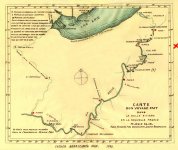
FRENCHMEN'S GOLD (Coudersport, Potter County) Ah, another legend of lost gold. Late in the 1690s, a group of French Canadians and Jesuits, led by Louis Frontenac, left New Orleans for Montreal. They sailed up the Mississippi to the Ohio, past what is now Pittsburgh and up the Allegheny. Their rafts were loaded with kegs filled with gold coins, worth $350,000 today, destined for the Royal Governor of Canada's treasury. After reaching present-day Potter County, they started overland, hoping to reach the Gennesee River and a straight shot to Montreal, but the heavy coins made the going slow. Fearing an Indian attack (the Senecas were long time enemies of the French), they decided to bury the booty just north of present-day Coudersport. They marked the spot with a cross chipped onto a large rock. The Senecas are said to have seen the marking, but left it alone because they feared the religious significance. In time, the marker eroded and the site was forgotten. The Frenchmen made it home, but never returned for their gold and to this day it's still buried.
 

Potter Poker

Full Member
Jan 29, 2007
227
9
Potter County, Pa.
Detector(s) used
Garrett Ace 250
Re: FRENCHMEN'S GOLD (Coudersport, Potter County)

Jeff, just found your post about the Frenchman's gold. I'm curious about some of the words used in your post: you mentioned "north of Coudersport", and they were "heading to the Genesee river"? Are you certain about these two statements? I only ask because my understanding of the legend is that they might have been heading to the Allegany river at Port Allegany. Also there is a mention of the location "Borie" in the story, which area is actually South of Coudersport. Please advise....C. Cole (Potter Poker)
 

GL

Bronze Member
Mar 2, 2008
1,595
39
South Central, NC
Re: FRENCHMEN'S GOLD (Coudersport, Potter County)

Kegs of gold coins would be worth several million today...I'd guess.

I honestly have no idea though. I know if I found 2 mason jars full of nice $20 gold coins from the 20th century I'd be rich. I can't imagine how much 17th century gold in that amount would be worth but I bet it'd be more than $350K!
 

deepskyal

Bronze Member
Aug 17, 2007
1,926
61
Natrona Heights, Pa.
Detector(s) used
White's Coinmaster 6000 Di Series 3, Minelab Eq 600
Primary Interest:
Metal Detecting
Re: FRENCHMEN'S GOLD (Coudersport, Potter County)

I've studied, checked maps, read the various versions of this legend, compared other events and so on for years, off and on.

I spent a lot of time exploring areas, driving back roads, fishing...lol...since I was in high school. That was back in the late 60's early 70's. Ive continued traveling to Potter County over the years for various reasons for the last 40 years, including the star parties at Cherry Springs.
I've hiked through Austin down to Costello, a part of Roulette, Coudersport and the Borie Valley.

It is a fact that back in the late 1600's, the French were working with the Jesuits in claiming land for the king. They planted lead plates along the Allegheny River claiming the area for the king of France.
This is about the same time the legend takes place of the burried gold. The Jesuits kept a written journal of the lead plate burials. I read the translated copy. Why no written journal of the burried gold? Could there be simply confusion between fact and fiction? Lead plates become burried gold?

The problem with what the curiator says about the rock being demo'ed is, they would have found the gold during the road building with all the earth movement they would have had to do in grading, leveling and debris removal. How deep do you think they would have burried the gold when they had intentions of returning and collecting?

If they had headed to the Borie Valley, it surely isn't the easiest way to the Genesse. Further, there just isn't the big rocks like the one "as big as a house" in that valley. There is a neat little family cemetary in Ayer's Hill, which is in the valley. Not suprisingly, it's called Ayer's Hill Cemetary. It's well maintained, or was back in the mid 1980's, and has off by itself a slave burial marker. Reads something like "here lies (so and so)?, he was a good slave". As you can tell, that left a life long impression on me.

And the other thing about this legend, they didn't have the benifit of aerial photos or surveys with GPS, or any kind of even the simplest of road maps. Any maps you look at from that era are all extremely vague. You have to remember they didn't have any kind of aerial advantage of where they were while boating and hiking through an area with no landmarkers of any kind.

One hill looked much the same as the other, peering through dense woods. Just how many valleys run off the Allegheny river heading north? Quite a few! Just look at the modern topos. There are several prominant valleys that go for miles heading north. If you're toting gold, even 100 pounds through rugged terrain, it would be exhaustive. They could probably travel few miles a day with full rations, equipment, gold....
Even the shallowness of the rivers back then....lots of raft pulling, portaging, etc. And you're going against the current in rocks.
Ever raft down Ohio Pile and get to the shallows and have to drag your raft across them with the current? Even that, I found, is a challenge. Talk about beating up your legs on rocks...OUCH!

I tried snorkeling at the Indian God rock for one of those lead plates the French burried. Late summer, low water, and I still could not hold myself in place because of a strong current. And that was only a few feet from shore.
I believe that plate is still there, just that it's probably under a couple thousand tons of RR fill.

But anyhow...maybe those travelers with the gold were just lost and made up names for where they were...or thought they were???

The Allegheny river flows up to New York from Pennsylvania, then South again. Why would they travel so much further south when they were already so far north, had they followed the Allegheny that far?
Wouldn't it had made more sense to take another river flowing south, before you got all the way to Coudersport? Keep heading north? Again, look at modern topos. I'm sure had they come across a wide valley heading north, thinking they would portage at some point to the Genesse, they would have gone up a valley before they got to Coudersport....kind of like Port Allegheny or even Portage Pa.

I don't doubt the legend, just the accurate location.
I think they would have stuck with deeper waters flowing south to take their northern route, mainly for ease of transport, if they had a heavy load. Reguardless of whether we call it a river, stream or creek now, if it had a high flow rate, to them that spells easier moving.

Besides legends, I have yet to see an actual reference to a document written by any of the explorers or countries of origin. There is documentation of those lead plates I mentioned. I read the references myself so I know it's factual. With so much supposed witness to the cross carved into a rock, why isn't there some historical documentation somewhere to confirm it's actual existence?

Paul Henson wrote of this legend in his book of Lost Treasures of Pennsylvania, but he didn't reference any documentation. I even wrote to him, telling him that Borie Vally wasn't a reasonable place for any burried treasure by a house sized rock. He never responded.

I even detected a few big rocks, "house sized" in Roulette. I figured after 300 years, any carving would have been obliterated over the years from weather or erosion and moss growth.

Those hills leading out of the valleys are steep and trecherous in many places. If you were toting gold, how far uphill are you willing to lug it, especially steep mountains? How long would it take you to just go a half mile through dense woods and rocks, twisting and turning, tripping, fallen trees and whatever other hazards you come upon in a wilderness situation?

Walk a mile in their shoes....then best guess where the gold might be.

I spent a lot of years with this in my mind....I wont find it in my life time...lol...if it's truely there :dontknow:

Al
 

simonds

Sr. Member
Feb 4, 2005
373
9
Tioga Co. Pa.
Re: FRENCHMEN'S GOLD (Coudersport, Potter County)

deepskyal
I don't think the gold would have been buried next to the rock with a cross chisled on it.
That would be like dig here to find the gold.
Large rock was only a marker to start from.
could have been a clue on the rock as to which way to go and find other markers.
The gold may be buried many feet away from the large rock.
just my own opinion.
 

zergkiller007

Tenderfoot
Sep 4, 2010
5
0
Re: FRENCHMEN'S GOLD (Coudersport, Potter County)

This was my first hunt. I started it knowing nothing with a friend. We got permission from a local farmer to search on thier land, they said we could check the rocks that were cleared from thier field and gave us a location, but we never looked. I doubt it is there.... as the previous poster said, the river systems dont make sence, they are WAY to low....

If anyone has any info on this please let me know,
Thanks.
 

deepskyal

Bronze Member
Aug 17, 2007
1,926
61
Natrona Heights, Pa.
Detector(s) used
White's Coinmaster 6000 Di Series 3, Minelab Eq 600
Primary Interest:
Metal Detecting
Re: FRENCHMEN'S GOLD (Coudersport, Potter County)

Okay....
Check this map out. This is a printed copy of the original map the Jesuit's used to place the lead plates Along the Allegheny River. It also shows the Route to Lake Erie, rather from Lake Erie if you note how the lead plates are numbered.

So, stands to reason, given this map has longitude and latitudes on it, these guys DID know their whereabouts.
Note again the guy who drew the map was a mathematician and used star charts for their locations. That was their guide to travel back then.

The coordinates for Coudersport area is W.78 degrees, N.41 degrees. That isn't close to where these guys were traveling. Not even on the Frenchmen's map. They show a system a good bit further west.
I'm going to go out for a long one here and make an assumption this map may have been used or even drawn up by a previous expedition so they knew where to bury the lead plates.
Closest East to Coudersport is W.79 degrees.
I painted a red X where Coudersport is approximately.
This legend is looking hollower....would like to see one itsy-bitsy shred of documentation on this. Just one.

Al

I think it would be some awesome detecting anyhow, back in the Portage, Port Allegheny areas, or what's that one called Put-In-Canoe or something funny like that. Some serious colonial hunting there I bet.

Al
 

Attachments

  • bonnecampmap paint.JPG
    bonnecampmap paint.JPG
    454.4 KB · Views: 3,115
OP
OP
jeff of pa

jeff of pa

Super Moderator
Staff member
Dec 19, 2003
85,844
59,630
🥇 Banner finds
1
🏆 Honorable Mentions:
1
Primary Interest:
All Treasure Hunting

zergkiller007

Tenderfoot
Sep 4, 2010
5
0
Re: FRENCHMEN'S GOLD (Coudersport, Potter County)

I strongly think this is a fictional story. The more I research it, the more I find that it is highly and i mean HIGHLY unlikely that it happened, I think you are correct when you said lead plates turned into buried gold. I was looking online and the person who buried them was the Gov. of New France at the time... So essentially the Gov. was taking the gold to himself in Canada, when he was having war with the Indians and the English farther north of the location of where it should be buried!

If anyone gets any further info on this topic that could support it please post it I am really interested. That map even shows an insanely long Portage they would have to take.
 

deepskyal

Bronze Member
Aug 17, 2007
1,926
61
Natrona Heights, Pa.
Detector(s) used
White's Coinmaster 6000 Di Series 3, Minelab Eq 600
Primary Interest:
Metal Detecting
Re: FRENCHMEN'S GOLD (Coudersport, Potter County)

The map above is long, considering they were claiming all the territories inside it as property for the king of France.
The book I read of the Jesuit's accounts was archived in the local library and translated to english. I didn't read the entire book as it was a reference book that you could not check out of the library, so reading time was limited.
But I did a speed read, flipping through pages and there wasn't anything written about gold that I saw. Jesuits were pretty serious about record keeping, keeping journals and accounts of travels.
It just doesn't make much sense to me that something as important as burried gold would go undocumented.

Al
 

EVERY DAYS A FRI.

Jr. Member
Jan 9, 2012
26
0
Primary Interest:
All Treasure Hunting
Re: FRENCHMEN'S GOLD (Coudersport, Potter County)

check google earth alittle above coudersport little down from rose lake anybody hunt around there . could logers make these patterns? looks to me like house two sqaure boxes @a big ol s would post but dont have clue tell me what you think good luck hunting e.d.a.f.
 

deepskyal

Bronze Member
Aug 17, 2007
1,926
61
Natrona Heights, Pa.
Detector(s) used
White's Coinmaster 6000 Di Series 3, Minelab Eq 600
Primary Interest:
Metal Detecting
Re: FRENCHMEN'S GOLD (Coudersport, Potter County)

EVERY DAYS A FRI. said:
check google earth alittle above coudersport little down from rose lake anybody hunt around there . could logers make these patterns? looks to me like house two sqaure boxes @a big ol s would post but dont have clue tell me what you think good luck hunting e.d.a.f.

Lots of areas in Potter county have big rocks...even as big as houses.....just none in Borrie Valley.

I fished all over Potter county with Couderport being the home base where we stayed at the same motel year after year. The other people I went up there with had a relative with a camp but I don't remember exactly where it was. Roads were still dirt back in those days around some places in the mountains...lol

In my later years I drove all over looking for places with big rocks, before the internet was available for information and I used libraries and historical societies, on-site research was the only way to confirm what was or wasn't somewhere.

If Countrygirl found something...I'd be mum about it too. People been looking for it for years (me included). Find one rock amongst thousands like finding a needle in a hay stack. And like I said, I've eyeballed many a big rock in Potter county and never found one with a mark.

Maybe there is some documentation somewhere that I've never seen, but from what I have found, I'm in the school of people that highly doubt it's existance. But I've been wrong before.

Al
 

TreasureWriter

Full Member
Nov 13, 2011
147
72
Primary Interest:
Other
I'm back from searching the Archives.....
I inadvertently found a picture with a large cross carved into a stone that was supposed to be in the same area as the Jesuit Treasure of the Borie while searching for information on Noah Parker and Gardeau. It's a poor quality photo and I can't make out the cross but it is labeled as such and was taken by a minister in the area and reprinted in a book. I also have a written backstory on how the cross came to be there in the 1600's but a lot of the story is an Indian legend and superstitious hocus pocus but does attribute the cross to being over 200 years old and carved by a priest or minister of some sort. The book was published in 1913 and never reprinted although I have copies of it's pages. I'm going to try to clean up the photo with a forensic photo tool to see if it helps but there are a couple of other discernible landmarks to go by. In the book there seems to be some conflict in the description of where the picture was taken exactly but it does give rough directions to the area. I'm trying to sort this out as well. The author didn't seem to know the treasure story behind the carved cross in the rock. Maybe this is the break that we have all been looking for? Or maybe it's just another dead end?

The information that I have says the rock was demolished in the late 1800's or early 1900's but it wasn't for road construction. So this rock is gone if it was the one; but with the picture and a general description of the location it might get me or someone else into the area to start looking.
I don't know what leads you guys are working on but it's like the old saying...I'll show you mine if you show me yours. If you're serious about looking for this then let's talk about teaming up. I haven't seen a better lead than this picture anywhere on this cache.

On another note...I also found a new picture of Gardeau (Blackbeard's Treasure in Pennsylvania) I posted it in the Pa Ghost Town Hunters Group. It's very interesting and shows the town from a different perspective than the other pictures that I've posted. Kind of feels a bit anti-climatic after finding the photo of the cross!
 

Last edited:

TreasureWriter

Full Member
Nov 13, 2011
147
72
Primary Interest:
Other
I've examined the map by Pere Bonnecamp. In my opinion it's not relevant. Bonnecamp's map follows the Allegheny River. Actually from Chautauqua Creek then to the upper Allegheny River, past the Clarion River and south past Kittanning to the Ohio River. This trip was over 60 miles to the west and nowhere near Potter County or any other place in Central Pennsylvania and while it is interesting that lead plates were buried establishing France's claim to "New France" I don't believe that it is in any way connected with the "Cross on the Rock" legend. I think that we are speaking of two distinct episodes.

Whoever carved the cross on the rock was not Celoron and Bonnecamp unless there is proof that they were on the West Branch and its tributaries which I have not found in Celoron's Journal.

What I do know is that there were a lot of Moravian missionaries in this area and they were on the West Branch and its tributaries. This may account for a cross being carved into a rock or it may not. Specifically, there are at least 2 Moravian Runs as tributaries to the West Branch. 1. is at the ghost town of Gallows Harbor 2. runs through the ghost town of Peale. My point is that there were other religious people here to convert the indigonous people who may have carved a cross in the rock.

I have yet to find factual documentation of a treasure at the rock.....but I'm still looking.
 

Last edited:

TreasureWriter

Full Member
Nov 13, 2011
147
72
Primary Interest:
Other
I do not believe that this would be in the Borie. These guys were traveling in long canoes up to 24 feet x 4 feet and weighing over 200 lbs. I haven't seen a stream large enough for them to navigate with these canoes in that area. Also if they were traveling from New Orleans up the Mississippi, Ohio and Allegheny Rivers......they were lost if they got into the middle of Potter County!
 

Last edited:

deepskyal

Bronze Member
Aug 17, 2007
1,926
61
Natrona Heights, Pa.
Detector(s) used
White's Coinmaster 6000 Di Series 3, Minelab Eq 600
Primary Interest:
Metal Detecting
I've been saying this for a long time. Borie valley is NOT the area! Been there, searched there, searched Coudersport, searched Austin, searched Roulette...never found documentation... compared it to the Bonnecamp expedition....just a story that's been passed on from some distorted history. Look instead for the lead plates burried by the travelers....that is a priceless treasure!!!

Al
 

TreasureWriter

Full Member
Nov 13, 2011
147
72
Primary Interest:
Other
I agree that the lead plates are a valuable piece of history. We know they are there and are worth looking for.

I think that the Bonnecamp map and the gold are two distinct treasures.

If the gold even exists at all.

My documentation leads us to a stream/river that cannot be accessed from the Allegheny River. I cannot see why the "Travellers" would have portaged East rather than follow the Allegheny if they were coming from New Orleans. I also have difficulty believing that the group paddled their way up the Mississippi to the Ohio and further north against the current. I know the Allegheny very well from Pittsburgh to Warren and without the dams it would have been a lot of riffles and white water as we see on the Northern Allegheny; no fun trying to go upstream. I think that if something is buried at the cross on the rock it was done so by an unknown group or the story got changed over 300 years. The story I found from 1913 has no mention of treasure with the cross. So either the author didn't know of it or the treasure story was added later as a hoax. I don't know the answer, but I'm pretty sure we have found the area from my book. The landmarks are all lining up but it's on railroad property. How do you detect around train tracks and a depths greater than a standard detector? Will a 2 box discriminate iron? What would ground radar show us? Guess we're going to have to find out.

Al,
I have Celeron's Journal in pdf format if you need a copy.
 

Last edited:

deepskyal

Bronze Member
Aug 17, 2007
1,926
61
Natrona Heights, Pa.
Detector(s) used
White's Coinmaster 6000 Di Series 3, Minelab Eq 600
Primary Interest:
Metal Detecting
Thanks Treasure Writer. Library has a copy I read years back. Pretty rough going back in them days...lol.

The lead plate at the Indian God rock may be a lost cause also because of the railroad that used to run next to it. And recently, they added a look-out over the rock in an attempt to keep people off it and stop the graffiti. If it's still there, it's eith under railroad fill or under the water because of the river changes. Either way, darn near impossible to find....but not totally...:icon_thumleft:. Small boat, maybe some snorkeling apparatus...water only a few feet deep there...and some way to anchor yourself from being swept away. I learned that the hard way...lol
One of the plates had been found by some kids fishing. They didn't know what it was and were melting it down to make fishing sinkers. There was a pic of that in the paper some years back. Think that plate was near Pittsburgh...Turtle Creek area maybe??? Too long ago to remember exactly.

Al
 

Dave500

Jr. Member
Apr 10, 2012
29
3
Pennsylvania
Primary Interest:
All Treasure Hunting
Thanks Treasure Writer. Library has a copy I read years back. Pretty rough going back in them days...lol.

The lead plate at the Indian God rock may be a lost cause also because of the railroad that used to run next to it. And recently, they added a look-out over the rock in an attempt to keep people off it and stop the graffiti. If it's still there, it's eith under railroad fill or under the water because of the river changes. Either way, darn near impossible to find....but not totally...:icon_thumleft:. Small boat, maybe some snorkeling apparatus...water only a few feet deep there...and some way to anchor yourself from being swept away. I learned that the hard way...lol
One of the plates had been found by some kids fishing. They didn't know what it was and were melting it down to make fishing sinkers. There was a pic of that in the paper some years back. Think that plate was near Pittsburgh...Turtle Creek area maybe??? Too long ago to remember exactly.

Al

You are mistaken. No lead plate was ever found near Pittsburgh.


Dave
 

deepskyal

Bronze Member
Aug 17, 2007
1,926
61
Natrona Heights, Pa.
Detector(s) used
White's Coinmaster 6000 Di Series 3, Minelab Eq 600
Primary Interest:
Metal Detecting
You are mistaken. No lead plate was ever found near Pittsburgh.


Dave

I do remember reading about it and it intrgued me enough to catch my attention as to it's closeness to the area. Like I said...I don't remember exactly where it was...but it wasn't far from Pitts. This was back in the late 70's or early 80's I believe when I read the article..but again, it was so long ago I don't remember exactly when the plate was found.....could have been an article of some past history or some current event...???

My point...one was found somewhere and it wasn't too, too far from Pittsburgh. I disinctly rememer the pic in the paper with a large section missing from the plate. This i was got me started on my quest to find another.

Al
 

Last edited:

Top Member Reactions

Users who are viewing this thread

Latest Discussions

Top