Jake Swansons silver

Rubicon

Sr. Member
Feb 9, 2007
302
1
Northeast Pennsylvania
Detector(s) used
Garrett Master Hunter CX Pro

Jay-in-Pa

Jr. Member
Jan 12, 2007
31
0
NE Pa.
Detector(s) used
Whites DFX
That is a heck of mountain to search, I was out poking around there last week behind the Belle plazza. I have been talking to an old timer in Scranton and he has a pretty good idea where the farm was.

Jay
 

jeff of pa

Super Moderator
Staff member
Dec 19, 2003
85,844
59,630
🥇 Banner finds
1
🏆 Honorable Mentions:
1
Primary Interest:
All Treasure Hunting
all I can Find on this one

zzzbm.jpg
 

DCMatt

Gold Member
Oct 12, 2006
10,356
13,478
Herndon Virginia
Detector(s) used
Minelab Equinox 600, EX II, & Musketeer, White's Classic
Primary Interest:
Metal Detecting
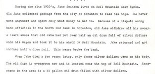
Wealthy hog farmer Jake Swanson withdrew all of his money from the bank at Scranton, converted all of his assets into silver dollars and placed them in a 55-gallon drum which he buried somewhere on his farm near the top of Bell Mountain N of Scranton. The money was buried after a dispute with bank officials in the 1930's and, after he died, the hoard was never found. 3. One searcher for the Swanson treasure said that a large pile of coal slag covers the old hog lot and farm, located just N of the Jefferson School on the Scranton quadrangle. 3A). An 80-year-old man says the farm on which this treasure cache is buried is actually located about 1/2 mile to the NW of this site.

Rubicon,

This may help. I looked at the 1890 & current maps. Not many roads around there, then or now. And NONE go anywhere near the top of Bell mountain (if I'm looking at the correct peak). If this guy had a wagon, he had to use a road. Also, if he had hogs, he had to have water. No water up there, either.

If you're serious about this one, see if you can get a death record for him. It may offer some clues.

Also, be aware that oil drums in the 1930's were more like 20 gallons - which makes more sense. How would old Jake have loaded or unloaded a 55 gallon drum half full of silver?

Good luck,

DCMatt
 

OP
OP
Rubicon

Rubicon

Sr. Member
Feb 9, 2007
302
1
Northeast Pennsylvania
Detector(s) used
Garrett Master Hunter CX Pro
I agree. Although current topographic maps show a pond at the top of the mountain, I doubt the theory that this was the farm location. You are correct as well that no roads went to the top of the mountain in 1890.
At this time, there is a road that leads to a radio tower.
The slag piles you mention also give credence to the theory that the farm was located further down the slope. Coal measures typically expose themselves at about the 1000 foot level in this area, or halfway down this mountain. Further, geographic inclinations limit the habitable area of this mountain to the southern and eastern sides.
I will try to follow up on the death lead.
 

DCMatt

Gold Member
Oct 12, 2006
10,356
13,478
Herndon Virginia
Detector(s) used
Minelab Equinox 600, EX II, & Musketeer, White's Classic
Primary Interest:
Metal Detecting
Do you know the "Jefferson School" that is mentioned? Give me a clue as to where it is located.

I found a Jefferson School in the area on a 1930 map, but it is 10 miles away from Scranton (Mt. Cobb?). It just doesn't feel right...

DCMatt
 

L

Lloyd in NEPA

Guest
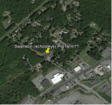
Rubicon,Jay and Dematt, I am 78. I live in Scranton. As A kid I attended Thomas Jefferson grade school, Its located about 3 miles from the site in question.The school they talk about was actually called, Bell Mountain school. It was torn down about 20 years ago. The pig farmers name was not Swanson! It was Schooley! Here's how to get to Schooleys pig farm. Take Rt. 6 out of North Scranton and head northeast toward Carbondale. You will Immediately Pass a Denny's Restaurant on your Right. The next Place on your left will be a Macdonalds. Slowdown, because you must immediately turn left after Macdonalds. Go 30 to 40 Ft. turn left and Head toward the big Building that is a Medical Bldg. Pass this bldg and head for Jo Anns Fabrics. You will find a Large parking lot. Bear to your right and proceed to the edge of the lot closest to the tree line. Look for foundations. Welcome to Schooleys Pig Farm. If you look close, you will find a 3 or 4 ft hole among the foundations, just as I did in 1957. I refuse to imagine the obvious. If you get as far as Macdonals and can't follow my convoluted directions just ask around . By the way I've been back there many times and all I ever found was stove parts.
 

OP
OP
Rubicon

Rubicon

Sr. Member
Feb 9, 2007
302
1
Northeast Pennsylvania
Detector(s) used
Garrett Master Hunter CX Pro
Thanks for the information. I don't like the sound of that hole though... :-[ Sounds like somebody beat us to it. ???
 

DCMatt

Gold Member
Oct 12, 2006
10,356
13,478
Herndon Virginia
Detector(s) used
Minelab Equinox 600, EX II, & Musketeer, White's Classic
Primary Interest:
Metal Detecting
The pig farmers name was not Swanson! It was Schooley!

Was his first name Jake (Jacob)? I find a Jacob Schooley in the 1880 - 1930 census in Luzerne county PA. He was wealthy. Had a lumber mill. Not sure he's the right guy, though.

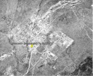
I found the location on Yahoo maps satillite photos. Good directions, Lloyd. Found the same place on the 1939 geo survey aerial photo of the area. But I can't see a house or foundation on either due to poor resolution and ground cover.

I suspect the loot has long-since been recovered.

It sure is fun looking, though.

:D

DCMatt
 

jeff of pa

Super Moderator
Staff member
Dec 19, 2003
85,844
59,630
🥇 Banner finds
1
🏆 Honorable Mentions:
1
Primary Interest:
All Treasure Hunting
Thing is, there is probably alot of large
pieces of Metal in the ground there.
Unless someone got Very Lucky
& found a Map to the Exact Location,
Or Extremely lucky & dug it on the First Dig,
One hole does Not suggest to me they got it.
 

L

Lloyd in NEPA

Guest
Jeff, I agree. There are lots of stove parts, sheet tin, pipes etc. still in the ground up there. The guy that dug the hole that I saw could have been inexperienced and ended up with a large pc of junk. Lloyd
 

jeff of pa

Super Moderator
Staff member
Dec 19, 2003
85,844
59,630
🥇 Banner finds
1
🏆 Honorable Mentions:
1
Primary Interest:
All Treasure Hunting
I have been to alot of old home sites.
& it seems alot of them have one deep
unfilled hole.

I personally think when most dig two
foot in the ground & retrieve Trash
they give up & leave.
 

Jd15

Newbie
Dec 11, 2018
1
2
NEPA
Primary Interest:
All Treasure Hunting
Anyone still looking at this, I just picked up the trail, did an image overlay of an aerial photo from 1939, that is as far back as an image can find. Also looking at old mine maps of the area for any clues, i did find a stone wall and wire fence listed around that specific parcel. It was one of the larger parcels in that area. Only problem i see is that part of what I believe to be the farm property has houses built sometime in between the 1939 and 1960 aerial photos. There appeared to be a stream that ran through the property which is also positive.
But Alas there is still a glimmer of hope as the section of the property that looks to be the most secluded and out of view from others at that time is still undeveloped.

I do alot of abandoned exploration so im pretty good with figuring out locations, but i cannot afford a metal detector at the moment.
1939
swanson 1.jpg

2017
swanson 2.png
 

Last edited:

Top Member Reactions

Users who are viewing this thread

Top