Turtle view from above.

Pala Y Pico

Full Member
Jan 18, 2011
216
15
Colorado and New Mexico
Detector(s) used
Tesoro Vaquero.
Primary Interest:
All Treasure Hunting
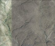
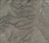
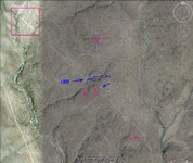
These satellite images are in northern Mexico, 1.82mi apart. There is a canyon between them.

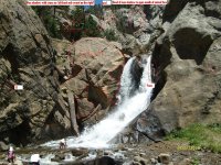
When my older brother was just a kid, his school teacher took them on an outing to this canyon.

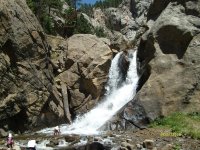
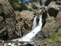
There is a natural spring that has been there since, before my 90 yr old dad can remember. The locals use this water to irrigate and play in the water.

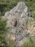
During this outing my brother and two school mates climbed the side of this small canyon. Before they could get to the top, they noticed an opening behind a jagged edge on side wall of canyon. when you look from the bottom of canyon, it just looks looks flat like nothing is there.

They entered the opening and my brother said it was big enough to fit my Dad`s house, as he
pointed to it. When their eyes started to adjust, to the darkness in the cave, they saw things wrapped in canvas type cloth. This scared them and in their fright they imagined the door smaller then when they came in. They ran out, pushing and shoving each other to get out first.

My brother said that as he grew up, he and his school mates never talked about the cave again.

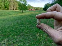
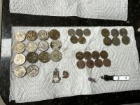
I just though I would share, about one of the things that's under my list in this area.

What are your thoughts on this two images?
 

Attachments

  • Capture.jpg
    Capture.jpg
    76.3 KB · Views: 553
  • capture2.jpg
    capture2.jpg
    61.7 KB · Views: 509

rangler

Bronze Member
Jul 12, 2004
1,320
200
The Land Of The Free Because Of The Brave!
Detector(s) used
for solutions to the jesuit code -email pics to: [email protected]


;[email protected] locations needed! oro bro!
Primary Interest:
Other
Senor Mario,
as seductive as these images might appear, they are not your best place to spend your time to find the goods...google earth houses graffiti of the immense kind, all natural or accidentally manmade with no promise but to wear your ass out on a wild goose chase..but hey if you decide otherwise remember the sage advice by Mr Springfied..."carry lots of water and bring a hat"
remember the Spanish built their monuments to be seen from ground level, and they had to be recovered by the Kings Men, not God, who before google, He would be the only one to see these..[pilots excluded of course]
the Nasca Lines are a false indication not to be confused with treasure signs.
I would be inclined to follow up on the story about the kids finding the cave than anything on google earth.
rangler

ps in some tiny extreme cases they did make images to be seen from some altitude - as I have found myself, but they were seen from a long distance on a mountain side or from an opposing mountain top/
DSC01582.JPG
(c)copyright 2007-all rights reserved -rangler
here you see an outcropping that was photographed from a mountain side that rose next to this outcrop. Here the awesome shadow of a knight templar on horseback with his sword drawn over his head. as a warning..do not trespass on this site.
 

Attachments

  • DSC01582.JPG
    DSC01582.JPG
    83.9 KB · Views: 510

poorfarm

Full Member
Feb 13, 2011
202
21
hi rangler i think he was talking about finding cave his brother found in the area he was showing
 

desertmoons

Bronze Member
Apr 16, 2008
1,067
168
Palo
What an interesting story. There are geoglyphs through the southwest , Mexico and points farther south. However I've not seen any that look like that.

BUT you may find they work for you simply because the spanish were all over the place. Everywhere you go, you will find something. And in Nothern Mexico, there was a rather advanced high culture, little known that got wiped out by disease and you may run across that if this is in Northern New Mexico.

I am not a photo analysis person, wish I was. So.. from an inexpert point of view, some things and questions stand out.
There are trails leading across the mesa/plain. Why? Why not just follow the rivers down below.

You have a very straight road that goes to the cliffs then continues on. Then you have the road around the cliff area ( the turtle hump)

If the road is as straight as it seems, it might be modern or it might very old and used for astronomical purposes or something like that. If it is old it might be interesting to follow that straight road both ways for a few hundred miles and see what settlements or sites pop up along that line.


The turtle head exhibits the same behavior. A straight line..then the trail around that rise or area. Why have two roads like that? Perhaps the straight road had other purposes than a road!

The pink square there may be some ruins in that area.

Now lets talk about the cliff area. You have rivers or stream either side of this mesa or plain. Then the cliff area might be a canyon coming up from one of the rivers. Who liked to live in such places? Anasazi or anyone else that needed to hide, but survive. They liked to build up in canyons like that during later periods when things were desperate. Thats assuming there is water there, and that is a canyon rather than just a cliff.

There seems to be some possible ruins in that area or at least possibly modified cliff side.

The blue dots ..there might be a foot trail there.


Now as I said I am no expert and things could look a lot different on the ground. But where there were Natives, Ancients or anyone, the Spanish were sure to follow.


Large signs are rather common, not rare, in my experience.

There are many modified mountain tops, mesas, cliffs, hills etc that have been modified on a very large scale for those that have eyes to see them. Not to be seen from above by the Gods..but meant to be seen miles and miles away, and not just range markers ala Kenworthy.

Are the all Spanish? Doubtful but many are.


The second picture the same thing...a straight road going up cliffs after cliff? Instead of following the countours of the land?
Does not seem an easy way to travel unless it is a modern road. The second sort of reminds me of alluvial terraces but I no know nothing of analysis at this level. On this second one..why have short roads going to the cliffs..perhaps not roads..those shorter ones might be geoglyphs or signs....
 

Attachments

  • palord1.jpg
    palord1.jpg
    81.2 KB · Views: 506

Shortstack

Silver Member
Jan 22, 2007
4,305
416
Detector(s) used
Tesoro Bandido II and DeLeon. also a Detector Pro Headhunter Diver, and a Garrett BFO called The Hunter & a Garrett Ace 250.
Primary Interest:
All Treasure Hunting
Moons,
You have some very good points. There were several groups of people, over the centuries, who came up from the south to settle in what's now the southwestern part of the US. Many sought out the type of landscape they used in their old home areas. The Aztecs and Mayans favored the mountainous country because they use the elevations for protection of their villages. The old stories about Montezuma's treasure have it hidden in Texas, New Mexico, and Arizona.........depending on whose story you're reading. Therefore, a cave in northern New Mexico would not be too far fetched; but is just one of the hundreds of possibilities. AND, not every old treasure cache is a Spanish cache hidden by the king's people. I know you are not "stuck" on the Spanish treasure trails stuff, but are also looking at all other things, too. :thumbsup: :thumbsup:
Also, today's roads usually follow the same routes as old trails because today's engineers look for the easiest route to follow just as the early scout / explorers did. After all, a trail route that could be used by carts and wagons could be improved to be used by cars and trucks.
 

rangler

Bronze Member
Jul 12, 2004
1,320
200
The Land Of The Free Because Of The Brave!
Detector(s) used
for solutions to the jesuit code -email pics to: [email protected]


;[email protected] locations needed! oro bro!
Primary Interest:
Other
senor Mario
speculation is nice, it fills a void, however it really is just that..and that will get you nowhere except for some entertainment and exercise your romantic imagination ... wiser councel would tell you to follow the signs on the ground... unless your trying to be an armature archeologist which is a oxymoron...but sometimes we need to take a break from the cold hard facts chiseled on stone - to relax and float on the clouds...it good for the soul...but not for the reality of chasing the codemakers art, which is much more demanding and strict rules apply, so letting your hair down once in a while can be therapeutic, you certainly can go there.... just dont live there...!
rangler

peace be unto the cloud readers as they add the levity we all need sometimes.

9993.jpg

(c) copyright 2005 - all right reserved - rangler
this is the eastern half of a janus rock, the western half was of an Amerindian
 

Attachments

  • 9993.jpg
    9993.jpg
    6.1 KB · Views: 507

desertmoons

Bronze Member
Apr 16, 2008
1,067
168
Well..as I understand it,

Northern Mexico until recently has been sort of a no mans land when it comes to archeological excavations. At least as far as US archies getting down there. As a relatively untouched area I would imagine they would keep it quiet even if they are down there.

A few hints of late Anasazi style shards or is it sherds..not black on white but the later stlyes they carried with them or assimilated from other civilizations. A reference to a T shaped door way. Stories of small characteristic cliff dwellings. Not saying thats where they ALL went...perhaps just some of them.

They were not the only ones to lay out roads going to "nowhere" in MesoAmerica.... but of course they are famous for the roads heading "nowhere" at Chaco. Roads that made no compromise for terrain. Clearly the bearing of the road was the important thing.

When trying to visualize the terrain those two straight roads cut across,and again this is amateur analysis...I would think there are easier ways to go. And they did make an easier way to go or someone did perhaps later on as you can see. The more natural go around the hill type of thing.

Now there is that other civilization..not Anasazi.
I seem to recall that the civilization that the early padres and very early Spanish reported on and that was gone 100-150 years later..used some lines of sight like that between their major settlements and trading centers.

Perhaps some one more experienced at such analysis could comment as I am very curious myself about those roads. And if they are modern.

Getting back to Spanish, note the early padres and Spanish reported on a flourishing civilization. Later on they reported very few people left, towns crumbling to ruin. However this would indicate to me they did travel through those areas and they rarely took trips just to sight see.
smiles.
 

Shortstack

Silver Member
Jan 22, 2007
4,305
416
Detector(s) used
Tesoro Bandido II and DeLeon. also a Detector Pro Headhunter Diver, and a Garrett BFO called The Hunter & a Garrett Ace 250.
Primary Interest:
All Treasure Hunting
Moons, those are some very astute observations and show you've done some research and study. What would be a great help in investigating the full history of the southwest would be if the Indian tribes would reveal their FULL oral histories and the FULL stories behind their "Story Sticks". But, they do not trust the archies because of their affiliations with the governments and the good Lord knows how they've always been screwed by the government. The same thing is true with the "historians". The Indian tribes are very, very slow to trust the euro-whites and, as such, no historical researchers have been willing to spend the necessary time to be accepted. The only exception I've read of is the guy who wrote the book, The Rocks Begin to Speak

Learning the FULL histories of the Navajo, Zuni, and the Hopi would be an OUTSTANDING experience. I think the other tribes such as Apaches, Cheyennes, Sioux, Arapaho, etc, were late comers to that country and came from somewhere "outside".
 

OP
OP
Pala Y Pico

Pala Y Pico

Full Member
Jan 18, 2011
216
15
Colorado and New Mexico
Detector(s) used
Tesoro Vaquero.
Primary Interest:
All Treasure Hunting
When the Pilgrims were landing on Plymouth Rock this place was being farmed by the Indians.
It is the oldest farming community, possibly in North America.

There are some high cerros you can climb and be able to see these shapes, but with out climbing one myself, I am only guessing. Pancho Villa and his men camped near here, while they fought with the Federales over a town.

desertmoons, as SS put it, "very astute observations and show you've done some research and study."
Hi poorfarm.
rangler that is a nice picture.
rangler, are these two man shadows, valid?
 

Attachments

  • Copy of S7300550.JPG
    Copy of S7300550.JPG
    259.7 KB · Views: 456

Old Dog

Gold Member
May 22, 2007
5,860
397
Western Colorado
Mario,
There is a large dot on the right, at the three o clock point on the picture that also grabs my attention.

All of these elements are supposed to be viewed from a distance.
You probably won't see any signs closer up.
 

Attachments

  • Copy of S7300550.JPG
    Copy of S7300550.JPG
    259.9 KB · Views: 540
OP
OP
Pala Y Pico

Pala Y Pico

Full Member
Jan 18, 2011
216
15
Colorado and New Mexico
Detector(s) used
Tesoro Vaquero.
Primary Interest:
All Treasure Hunting
Thom,

My son took this photo.
I am starting to see more stuff, yikes!
I will wait to see what else you and others see.
What is the meaning of the dot?

Mario
 

Shortstack

Silver Member
Jan 22, 2007
4,305
416
Detector(s) used
Tesoro Bandido II and DeLeon. also a Detector Pro Headhunter Diver, and a Garrett BFO called The Hunter & a Garrett Ace 250.
Primary Interest:
All Treasure Hunting
Mario:
There's a lot of things here. Check them out and make up your own mind as to what is important and what is not.
That water looks COOOOOOOLD!!! LOL

Copy of S7300550 Merged Merged.jpg
 

OP
OP
Pala Y Pico

Pala Y Pico

Full Member
Jan 18, 2011
216
15
Colorado and New Mexico
Detector(s) used
Tesoro Vaquero.
Primary Interest:
All Treasure Hunting
This area lies on approx. 20,000 square meters mines area, which was once owned by three brothers that owned a bank. They possessed the land since 1881. The area was donated to the city in 1914.

A few climbers have incurred deadly incidents climbing this rocks.

I wonder if these brothers missed anything.
 

OP
OP
Pala Y Pico

Pala Y Pico

Full Member
Jan 18, 2011
216
15
Colorado and New Mexico
Detector(s) used
Tesoro Vaquero.
Primary Interest:
All Treasure Hunting
There is lots of stuff here, Shortstack. I would think that at least to say, something is going on here. Most of it probably to confuse us. Since all that is needed is true valid symbols for distance and direction. I hope someone will point those out.
 

Attachments

  • Copy of S7300550.JPG
    Copy of S7300550.JPG
    266.4 KB · Views: 424

rangler

Bronze Member
Jul 12, 2004
1,320
200
The Land Of The Free Because Of The Brave!
Detector(s) used
for solutions to the jesuit code -email pics to: [email protected]


;[email protected] locations needed! oro bro!
Primary Interest:
Other
Mario,
I think this is a monument, however I cant find enough iconic symbols in this pic.
Unless the dot is really a hoya...and that would make 5 icons..[and that would be a first for me, to see them use a hoya instead of a hoyo..as part of the icons needed.
Right now it looks like some trail signs leading you 'mas alla'
The very stark \/ sitting on top of /\ looks defiantly man made, one of the legs of the /\ point directly to the black dog, black dog is looking at man shadow..giving it credibility other wise without another sign in context, it would be without validity..then the man shadow is pointing somewhere off the edge of the pic, as far as I can tell from this angle..
looks like very interesting mountain side...to say the least, are there mines nearby?
rangler
Copy of S7300550 2 marked rangler2.jpg
 

Old Dog

Gold Member
May 22, 2007
5,860
397
Western Colorado
Pala Y Pico said:
Thom,

My son took this photo.
I am starting to see more stuff, yikes!
I will wait to see what else you and others see.
What is the meaning of the dot?

Mario

Mario,

The isolated dot says "water"
As a matter of fact almost all the signs deal with that stream in one way or another.
The largest of the signs looks down into the water, so I am tending to think there may be something hidden in the stream itself ...
See if you can get closer and get a better look at the small signs that won't show from this distance.
Watch especially for water signs with dots or square shapes in the center of them.
 

OP
OP
Pala Y Pico

Pala Y Pico

Full Member
Jan 18, 2011
216
15
Colorado and New Mexico
Detector(s) used
Tesoro Vaquero.
Primary Interest:
All Treasure Hunting
Hi rangler.

Yes, this particular spot sits inside an area owned(1881 to 1914) and mined by three brothers. This brothers started a bank, that I think is still in existence.

The last time there was a forrest fire, not far from this area, some one was showing the fire fighters were not to walk, so they would not fall into mine shafts.

I wonder.... if this brothers mined the mines and missed the Spanish goods hidden.

I did not see the black dog, but the same shadow (eye of the skull in my mind) I thought looks like a bell.

The man shadow pointing to the edge of picture, do you think it is pointing to shadow with possible upside down owl shadow?

Thank rangler
 

Attachments

  • Copy_of_S7300550_2_marked_rangler2[1].jpg
    Copy_of_S7300550_2_marked_rangler2[1].jpg
    266.2 KB · Views: 379
OP
OP
Pala Y Pico

Pala Y Pico

Full Member
Jan 18, 2011
216
15
Colorado and New Mexico
Detector(s) used
Tesoro Vaquero.
Primary Interest:
All Treasure Hunting
Thanks Thom,

I remember as a kid, swimming in the irrigation ditches. And where there was a drop off, as like in a water fall, I would be able to find a spot behind the water. I could hide there without no one seeing me for as long as I wanted.

I was thinking the same thing. Maybe some where, behind the water is the spot.
 

Top Member Reactions

Users who are viewing this thread

Latest Discussions

Top