Unusal Rock

D

dowser501

Guest
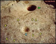
River < the twin holes in Indonesia were neatly carved out of a huge permanent slab of flat rock, and were identical to seen on above. It just shows the extent that the influence of the Jesuit mining and caching influence extended to in their reign of religious enlightment combined with their pacific wide mining activities. I have had much info recently on evdence of similar activities in the nearby Philippines.
All their markings were singly mindedly to do with mining and hiding the proceeds.
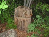
I have spent 20 years interpereting Jesuit signs as a hobby and I am sure the round holes are telling you that there are two caches buried in the vicinity. THey also cut down trees and hollow out the centres of the stumps for the same reason. The square cut hole can only be to do with a mining shaft.I call those markers commodes. My first encounter with commodes was about 1990 and I was exploring a jesuit tunnel complex solo, and about 100 foot inland I broke thru a blockage and encountered a fair dinkum hand made out of sandstone commode with a 2 foot deep by a foot wide hole offset from its centre., which I felt instinctivly meant to dig downwards on the right which was correct. The accompaning photo of which I have stored over 2,000 shows another variation of the holes in the rocks.THe stump has a hole not dead centred and is pointing at the underground cache, and is another variation of the round holes in the rocks. So you know they mean business < they have place a large pointer or companion rock pointing at the commode hole. Max
 

Attachments

  • image021.jpg
    image021.jpg
    11.3 KB · Views: 1,073

bytheriver

Full Member
Jul 11, 2006
188
1
Dowser

Thanks for the big mini Dowser lesson this AM. Something new every day.

I found the program on the Geo channel and my eyes are not trained to look for Jesuit Trees. However, towards the end of the program I saw an aged survivor of Pearl Harbor looking up and there was a tree in the background, sort of gnarly and twisted...did I see the Jesuit Tree?

Thanks again

River
 

bytheriver

Full Member
Jul 11, 2006
188
1
I found a website with rock art describing the "Cuplues" or "Tacitas". Cupules frequently represent the oldest surviving rock art of an area.

Hope this helps. I still dont have a total understanding of what I just read, but at least some light has been shed on the subject.

Dowser 501 these are just like the slab you saw on the National Geographic Channel. Being a learned man you may already know of this, but I sure am exicted with this site. Very informative for beginners like me wanting to learn how to decipher the treasure codes articulated into the rock as signs and symbols.

By the River

http://rupestreweb.tripod.com/tacitas.html
 

Attachments

  • TAsita.jpg
    TAsita.jpg
    23.8 KB · Views: 1,109
D

dowser501

Guest
I will insert a tree trunk with the same message on it.THey were telling you with multiple fingernail shaped holes (7 dedos) sometimes more, that gold is nearby.
 

Attachments

  • P5110003.JPG
    P5110003.JPG
    32 KB · Views: 1,009

hollowpointred

Gold Member
Mar 12, 2005
6,871
56
Detector(s) used
Minelab Explorer SE/Garrett GTI 2500/ Ace 250
if i were you, i would take these photos to the local university and ask if the archeology department would have an opinion on what the markings are. just dont tell them where it is! ;D (just kidding). there has to be a native american expert that can shed some light on the markings.
 

bytheriver

Full Member
Jul 11, 2006
188
1
Dowser 501

That tree stump looks like someone used it as target practice for their gun!...only you can see it a "Treasure Map" LOL....LOLLLLLLL :)

So much to learn about Jesuit Trees, and here I sit trying to earn a living; at my work desk reading posts!

By the River
 

bytheriver

Full Member
Jul 11, 2006
188
1
Dowser 501

During the day, as time permits I look for new articles on Indian Thong Trees and also read the new posts on TN.

The university is pretty quite at this time of year so this had allowed me some free time to catch up on some reading and searching.

I really do earn my paycheck! Wouldnt have it any other way!

Instead of the attending the Christmas Party today I decided to stay behind to clean up my work area and actually scrubbed the floor!

Merry Christmas

By the River!
 

Light Foot

Greenie
Nov 14, 2006
18
1
Utah
The F5 may represent a family of five
3 circles may= the children
1 square may=the wife
The rock carver may= the grieving father
I submit that it is a grave marker
May sound way of the wall but someone would have to have a very emotional reason to take this amount of time to carve. But hay, then again it may very well lead to treasure.
Another possibility is religious or cult. Whatever it is, It had to be extremely important to the maker.
The square might imply the use of metal tooling.
It does seem to be a one of a kind stone.
Way cool. Can't wait to find out what it really is.
Mark
 

OldBillinUT

Full Member
Feb 7, 2004
153
11
What a find ! Just wondering if you have seen the bottoms of the holes ? Any luck getting all the other markings on the rock? I am wondering if this is a sighting device of some kind maybe ? Another thought magnetic N may have changed since the time it was put there right ? Does anything else appear in 3 forms or groups on the rock ? Any markings below ground level ?
 

bytheriver

Full Member
Jul 11, 2006
188
1
FNG

While browsing the KGC Treasure Legend site I found this post from September2005. Gives a description of a template with circles and a square in the middle. This equals treasure is located close by. I know this is far fetched, but your unusual rock is very intriguing and it long held secret needs to be revealed.

I copied the post:
Albert Osborn
Jr. Member
Offline

By the River

Posts: 79

Re: Knights of the Golden Circle
« Reply #50 on: Sep 22, 2005, 04:20:56 PM » Quote

--------------------------------------------------------------------------------
ANYBODY BELIEVE IN MIRACLES?

Well, I don't, but listen to my story. All of you are familiar with Brewr's
book On page 235, there is a template. This template does not tell
you what state or what region the treasure is in. It is a waybill to caches
at any location. The square in the middle is the major one. Each circle
represents a cache location in the area around the big one
.I was working a map for
this guy and discovered it was buried in a well. Now, I knew of a cache buried in a well less than 2 hours driving from my domicile. While I was looking at the map I had just done for this guy,
I thought--now is a good time to see what I can do with this template.
Took me a while, but I located the master deposit (the one in the square)
I decided to look at my well. It wasn't in the square, but by manipulating
the template, I locate the big one ($600,000) and from there, I located
one in every circle of template. I suppose you would have to be a map
dowser to do this, but any dowser should be able to accomplish this.
I want to thank my God who had to be watching over me. After all. I'm
not smart--- just an old country preacher. You guys have fun.
 

OldBillinUT

Full Member
Feb 7, 2004
153
11
Are you are certain this is natural stone and not a casting of some kind ? I see in one of the round holes other circles what is this ?

If it is natural stone then mark a line from the exact center of each round hole to the centers of the others making a triangle. Next mark lines from the corners of the square to make an X. Now another from the center of the single hole and crossing the center of the X to the base of the triangle. Measure the lines. Take a south sighting along this line and use the numbers you found on the stone. What do the shapes formed by the intersections of the lines point to ?
 

starsplitter

Sr. Member
Jan 20, 2007
434
31
It ocurred to me that your rock might been the base for a machine. The circles could have held round posts/poles of some kind and the square a "squared" post or pole. If you think about it, whatever fits in the square cannot be torqued out of position (kind of like a ratchet). The round poles/posts could have been additional supports.

In any case, none of it looks natural. I think the other posts are offering good advice: check around and under (if possible) it thoroughly, and get a good topo map (digital, even layered versions are sometimes available at the county engineer's website), a GPS (don't forget to pull the batteries after use if borrowed), and perhaps a transit. Then, start playing with the geometry.

Cool, unusual, and fun - even if you don't find anything. It always feels good to be out in nature.
 

Top Member Reactions

Users who are viewing this thread

Top