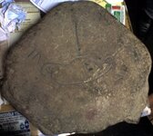
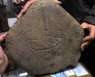
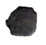
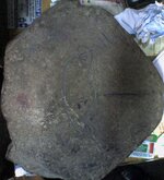
treasure map

OP
OP
Z

zallpall

Jr. Member
Mar 30, 2012
26
0
Primary Interest:
All Treasure Hunting

peralta

Sr. Member
Sep 28, 2011
389
45
oahu hawaii
Detector(s) used
Whites 2-box
Primary Interest:
All Treasure Hunting
Very nice find now remember that you have to start looking at everything you to find a starting point.there should be something on that stone that is a physical marking on land or mountain. It doesn't matter if its five miles away or fifty,, one of the pointers or shapes is around. You will have to work with with a plan to follow.follow. you will make a list and follow it.check rivers or old dry streams,,mountains and foothills, giant boulders sitting in the middle of nowhere, .use your camera on each venture. It might be a line pointer on the side of a hill.check your photos for large mountain shadows.look for any other large stones in the same site. Turn them over if you can.I once found one stone with markings and turned another stone over and it showed more markings.markings. think they put one face down to protected from the elements.are there boulders in lines around you?the shape of the oval marking looks like a form to look for. The opening with three lines may be your entry marker on one boulder marked with three lines to let you into a cashe. Good luck, keep me informed
 

Indiana$Dirk

Jr. Member
Mar 25, 2012
42
5
Primary Interest:
All Treasure Hunting
This map was made by a Greek person.These bandits had been in the leadership of Greek orthodox church against Turkish army about hundred years ago.

OK. Since the priests of the Greek Orthodox church are the ones who hid the treasure from the Turkish army, I suspect that much of the symbols come from religious belief. You will need to educate yourself on the meaning of Greek Orthodox religious symbols. (Here in America, much of the Spanish treasure was hid by Jesuit priests and they used catholic religious symbols on their maps and way bills.) There may be some similarities with Greek Orthodox symbols.

I can't see all the symbols on your rock well enough to comment on what they might mean. You may want to make a scale drawing of the rock clearly showing all the markings.
 

OP
OP
Z

zallpall

Jr. Member
Mar 30, 2012
26
0
Primary Interest:
All Treasure Hunting
Photo-01893.jpg Photo-01907.jpg
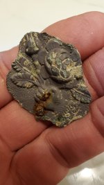
here are better photos.
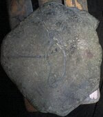
the blue coloured pen prints are the original hand carvings on the stone.The rest is just shadows and natural seeming of the stone.
 

Last edited:
OP
OP
Z

zallpall

Jr. Member
Mar 30, 2012
26
0
Primary Interest:
All Treasure Hunting
Photo-019152.jpg Photo-0188.jpg Photo-0187.jpg

if you check the photos,you caan see hand holding the stone,which will give you the best idea about the scale of the figures.
 

OP
OP
Z

zallpall

Jr. Member
Mar 30, 2012
26
0
Primary Interest:
All Treasure Hunting
Untitled-2.jpg
here you can see all the figures on the stone map.
 

usernotfound

Sr. Member
Sep 7, 2011
495
148
Detector(s) used
T-2
Primary Interest:
All Treasure Hunting
"Sun with line" could indicate east and west direction and and the sigular long line could be northwest. At my location, Northwest was the direction of travel because of the numbers associated with Biblical numeralogy. It could help if you posted a large picture of of the area (several miles) with the stone map oriented how you found it... Another thing to consider is if the stone they used was local "does it look like the rest of the rocks in the area?" or can you find that particular rock type in the area. Wish you the best in your quest.
 

Indiana$Dirk

Jr. Member
Mar 25, 2012
42
5
Primary Interest:
All Treasure Hunting
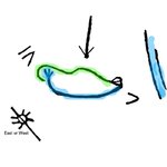
possible interpretations

OK Here is a possible interpretation of the map given that i don't know anything about the topography or geography of the area.

interp1.jpg

Given my lack of knowledge, i'm going with the idea the the green line represents hills or mountains seen from where you dug up the stone. the blue line is a creek that starts in three branches that come together and flow down and to the right. The green and blue lines meet perhaps at some building or town. ?? The two vertical lines with blue may represent a large river some distance off in that direction. The line down from the top may be like an arrow pointing to the high point of the hills/mountains possibly indicating the location of the treasure.

The sun with line through it may indicate either East (sunrise) or West (sunset). If it represents East, then you should look to the Southwest to see the hills and creek. But, If it represents West, then you should look Northeast to see the hills and creek.

I'm fairly certain that the V and VI are Roman numerals representing 5 and 6. but I don't know if that means miles, or kilometers, or whatever? Also I don't know what they measure....

On the other hand, the green line may represent a road while the blue line represents a creek as before. In this case, the 5 may mean the creek is 5 miles long and the green road is 6 miles long. ??

Anyway, these are some ideas to think about. they may be totally wrong, but...........
 

OP
OP
Z

zallpall

Jr. Member
Mar 30, 2012
26
0
Primary Interest:
All Treasure Hunting
can this figure represent a dove or a snail?if so,then how to read and interpret?
and the numerals;the greek orthodox priests in the region had used arabic letters and numerals too and then the V and VI in the map might mean 7 and 71 or if map is held downwards then 8 and 18.
 

Last edited:

Indiana$Dirk

Jr. Member
Mar 25, 2012
42
5
Primary Interest:
All Treasure Hunting
can this figure represent a dove or a snail?if so,then how to read and interpret?
and the numerals;the greek orthodox priests in the region had used arabic letters and numerals too and then the V and VI in the map might mean 7 and 71 or if map is held downwards then 8 and 18.
One might see it as a dove or snail, but I've never heard of any thing they might represent. It seems to me that they would want to indicate recognizable landmarks and include measurements and headings. I'd be careful of getting to esoteric, overly symbolic. I think that they would tend to be practical. They buried the stone so that only those who knew where it was buried could get it. That would not be the Turkish army (hopefully). So I don't think they would try to be too obtuse in the clues on the map. KISS (keep it simple, stupid) is a good thing to keep in mind. :icon_thumleft:
 

Indiana$Dirk

Jr. Member
Mar 25, 2012
42
5
Primary Interest:
All Treasure Hunting
I spent several hours searching all over Greece on Google Earth for the roads and burial site. no luck. I was hoping to look around on Google Earth to see if i could find hills and rivers etc.....
 

Shortstack

Silver Member
Jan 22, 2007
4,305
416
Detector(s) used
Tesoro Bandido II and DeLeon. also a Detector Pro Headhunter Diver, and a Garrett BFO called The Hunter & a Garrett Ace 250.
Primary Interest:
All Treasure Hunting
$Dirk:
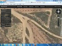
Forget Google Earth. There are better sat sources with better, clearer details. Here's the one that I use and I'm posting a screenshot I just took of an area on the outskirts of Athens to illustrate. It's at the highest magnification (lowest altitude) and has an automobile on a road. Just make sure the bing maps selection is checked in the box on the left side of the screen.
The link is : Flash Earth - Zoom into satellite and aerial imagery of the Earth in Flash
Use the bing maps with labels selection to get the roads and highway names and numbers.
Here's the screenshot:

Capture4-11-2012-5.19.52 PM.jpg
 

Last edited:

Indiana$Dirk

Jr. Member
Mar 25, 2012
42
5
Primary Interest:
All Treasure Hunting
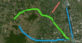
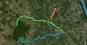
This first image is a possible solution to the map. It is a first try and probably not correct. The square shows where the rock was burried. I am 100% certain of the meaning of the vertical lines symbol--the river!
View attachment 625994
The second image may show a more correct solution, but...... stiil dont know what the little curved lines are at the right side of the figure. A House, A church, A town. ????
View attachment 625995
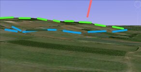
The last image shows the hills up behind where the map was buried. It makes sense that the treasure could be on top of the hill. That's better than somewhere along a road. but who knows.
View attachment 625996
It would be good to know which buildings that exist today that didn't exist then.....
 

Last edited:
OP
OP
Z

zallpall

Jr. Member
Mar 30, 2012
26
0
Primary Interest:
All Treasure Hunting
"usernotfound" nothing else...it was buried as sticked under a square shaped limestone.
 

OP
OP
Z

zallpall

Jr. Member
Mar 30, 2012
26
0
Primary Interest:
All Treasure Hunting
"usernotfound " the church was wooden and it doesnt exist anymore.
 

Indiana$Dirk

Jr. Member
Mar 25, 2012
42
5
Primary Interest:
All Treasure Hunting
Zallpall: was anything I talked about helpful? Do you live in the area?
 

OP
OP
Z

zallpall

Jr. Member
Mar 30, 2012
26
0
Primary Interest:
All Treasure Hunting
Indiana$Dirk : your comments give idea,but I doubt about scale ratio.I do not think that the map covers such big area.I know the area very well in any distance.
 

Indiana$Dirk

Jr. Member
Mar 25, 2012
42
5
Primary Interest:
All Treasure Hunting
I provided 3 different options of differing scales, but all in the same general area. I think the last one, showing the hills just NE of the burial site of the rock, is probably the closest to the correct interpretation of the map. If I were the priests wishing to hide church treasures, I'd do it in the middle of a forest/woods on top of a hill. That location is likely to have the least amount of future development, i.e. new houses or roads or farms. And I could do so while hidden in the forest out of sight of most people -- especially an enemy army. And there would be many possible places to hide the artifacts.

I could dig a hole between some trees. I may find a small cave to stash the treasure in and then cover the entrance up. I could find a hollow tree and put it in a tree. Then I'd put some kind of marks nearby on trees or rocks that would only make sense to me and those to whom I told about the treasure. And then I'd make a map to show how to get to the marks in the forest, and bury it in a special location.

Where was the church located? Also. Was the place where the map was buried indicated by any kind of mark or sign?
 

Last edited:

Top Member Reactions

Users who are viewing this thread

Top