Old Spanish trail monument destroyed "who does that"??

OP
OP
Goldstar1

Goldstar1

Full Member
May 22, 2010
222
295
Detector(s) used
Goldbug Pro ,
Equinox 800
Primary Interest:
All Treasure Hunting
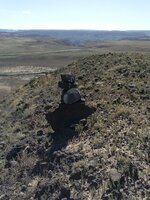
CAM00598.jpg Heres this little guy, it is part of the first cluster of stuff , yep just about 2.5 miles from the placer area in the background, I will try to map and measure the others in this set and put something together . The next cluster is about the same distance from the markers I posted . I interpret this as a guarded camp , but could be way off ,Im certainly interested in other opinions on this.....
 

dsty

Bronze Member
Dec 2, 2007
1,300
736
Randal County
Looks to me as if its very possible a Royal Trail, The only way that I would have an Idea is if all of them have a flat surface and a direction indicator is a must on the top stone or possibly a nearby flat stone that's for sure pointing away from the canyon, each pile may Indicate another trail, and The best that I can say is that a Royal Trail seems to be without the standard measurements, They seem to be 2.5 miles apart, 66 inches may be what you are looking for height ( its just double what a normal pace would be Thank You SS ), I think that the Little Guy is a Trail watcher and very possible the direction of travel is Reverse. There will always be two at a corner marker, your guy and the head that its sitting on
 

OP
OP
Goldstar1

Goldstar1

Full Member
May 22, 2010
222
295
Detector(s) used
Goldbug Pro ,
Equinox 800
Primary Interest:
All Treasure Hunting
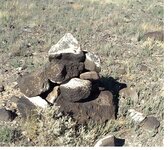
pointer.jpg Thanks again dsty, yep your dead on with this one , here is the next in this little cluster, a flat pointer pointing from this side directly away from the canyon, would you think this is a false pointer and the actual direction of travel is the opposite direction (that was my thought as it doesnt seem right where it is pointing but maybe...) . Seems like alot of info just in this little cluster, I havent been able to get back there for exact measurements but when i was there i did pace it out roughly and the result was : from where i started the first one just a large pile (with a notch on top but hard to tell if it had been altered) to far to pace out so I didnt , but from the next one it goes , 160, 72, 38, 14 . Of course this is very rough and i will have to get exact measurements and map it to give a better picture of the layout. The more I think about it I wouldnt be suprised if the placer area was worked , it is fairly fine gold but consistant and could have been easily worked back then year round, its way off limits now but might be an interesting part of the history , I will have to check it out again and i can still take pictures there. I still have a hunch this was part of a much older trail, even just today I got a startling little article about the area!
 

dsty

Bronze Member
Dec 2, 2007
1,300
736
Randal County
Hello best b 4, I do not believe that Lost Horse has gleaned all of the information off her map rock ( BOULDER ) I believe that the marble size dots represent 5 leagues or 12.5 miles and may be the distance traveled in a day, On your post yesterday, there's a direction indicator and how high should be distance, I would not expect to see any other marks until you had gone that distance and direction. I really do like the flat top on the top stone, it may indicate royal trail looks to be 33 inches high could be 1 1.2 league or perhaps 2 leagues I think I would check both, All this for the most part is just a guess. If you don't find any sign at either location it may be covered over, anyway I really believe your are on an exciting journey, and Google earth may be a lot of help, if a overhead shot shows a circle in the area it would really get my heart pounding. The map may indicate a distance which could give you the length and width of the canyon
 

Ecominer

Banned
Mar 20, 2003
124
61
Albuquerque, New Mexico
Detector(s) used
Fisher Gemini III; Garrett Master Hunter;2009 Minelab Explorer SE Pro; Quantro Discovery Land Tone Magetometer 1A;
Primary Interest:
All Treasure Hunting
if your cairns are getting smaller they will eventually end. Then start looking for smaller pointer rocks. The smaller they get the closer you will be getting to a site. your picture above obviously hs a pointer rock(to the right) which would probably be your direction of travel. Your pointer could be pointed to a village, water, camp site, or mining site. But as always, a pointer is pointing to something or away from something. usually royal trails will have animal figures as pointers. If you don't have these it is something less valuable.

If your cairn is just on the top of a small hill, which it does not appear yours are, it could just be built by a sheepherder indicating a good place to pasture the flock.
 

OP
OP
Goldstar1

Goldstar1

Full Member
May 22, 2010
222
295
Detector(s) used
Goldbug Pro ,
Equinox 800
Primary Interest:
All Treasure Hunting
dsty , did you get my pm? , I dont see it in my sent box
 

OP
OP
Goldstar1

Goldstar1

Full Member
May 22, 2010
222
295
Detector(s) used
Goldbug Pro ,
Equinox 800
Primary Interest:
All Treasure Hunting
No problem dsty , thanks for your helpful info!
 

Sing Reseracher

Jr. Member
Nov 4, 2014
96
24
Iran /Tabriz
Detector(s) used
Many of detectors for example lorenz x3 /x5
Primary Interest:
All Treasure Hunting
Hi . i invited you to Participate in classes of the Treasures signs & marks

The first lessons of the treasure signs

Thanks
 

Top Member Reactions

Users who are viewing this thread

Top