Old Spanish trail monument destroyed "who does that"??

Goldstar1

Full Member
May 22, 2010
222
295
Detector(s) used
Goldbug Pro ,
Equinox 800
Primary Interest:
All Treasure Hunting
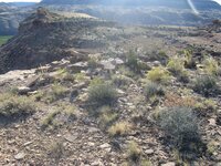
Here is a picture of an old Spanish trail monument rock cairn from last year , I recently was back there and it was completely torn down . Who would do this ?? I am angry to say the least! this is/was part of a long string of trail monuments , it is in a location that is not in any known party spots or common areas and one would have to make a real effort to destroy it. From memory it was about 10-12 ' tall. My only guess is some idiot that thought they were on to something they did not want others to see (which is absurd since there are many others out there that are far more significant) or a nearby land owner that did not want anyone snooping near their land or having it dedicating it a historical area?? who knows any ideas are welcome and have others experienced the same thing ? 243 (2).JPG 234.JPG
 

Last edited:
OP
OP
Goldstar1

Goldstar1

Full Member
May 22, 2010
222
295
Detector(s) used
Goldbug Pro ,
Equinox 800
Primary Interest:
All Treasure Hunting
Here it is obliterated
 

Attachments

  • 025.JPG
    025.JPG
    1.4 MB · Views: 182

dsty

Bronze Member
Dec 2, 2007
1,300
736
Randal County
best b4, If you think its Spanish I would look in all 4 directions E W N S for a distance of 2.5 miles using Google Earth, Others used things like it to mark a trail such as from. St Louis to Calif. Folks used whatever was close at hand to serve their means and could be seen from a distance, I have seen folks that said they were section corners used with a transit and such. Because it was High My guess would be trail marker. You can get it figured out, stuff like that just is
a challenge to some folks. When folks start going on their property with out permission they do things like that, or worse than that rock chips from a near by boulder shower you. With chips.Use Google Earth, you can see more with out get getting shot at or going to jail. In my part of the country Trespass no problem $100. and you are buzzard bait
 

OP
OP
Goldstar1

Goldstar1

Full Member
May 22, 2010
222
295
Detector(s) used
Goldbug Pro ,
Equinox 800
Primary Interest:
All Treasure Hunting
Thanks for the reply. Yes I believe it is Spanish , there are many many markers and such in this area all leading to trails this is an example of a very basic one just a simple rock cairn, but these simple ones are intermixed with much more elaborate ones and some very precise measurements. I think they are part of a much older trail as well and of course newer settlers and such like you mention. The whole area almost seems like a giant survey . I might post some other stuff from here but probably more appropriate in a different thread, this was just to ask peoples opinions on why someone would destroy this. I have seen other rock monuments and petroglyphs destroyed in the area but they are easy accessible party spots where i think people get drunk and just do stupid stuff. google earth is not much help here . And just to be clear also this is NOT private property and I would not trespass, there is some private property nearby which is clearly marked which I am very respectful of.
 

Shortstack

Silver Member
Jan 22, 2007
4,305
416
Detector(s) used
Tesoro Bandido II and DeLeon. also a Detector Pro Headhunter Diver, and a Garrett BFO called The Hunter & a Garrett Ace 250.
Primary Interest:
All Treasure Hunting
That cairn was built to be seen from the trail, below, and from a distance. It won't be the only one around, so have any other markers been destroyed in the area?
 

OP
OP
Goldstar1

Goldstar1

Full Member
May 22, 2010
222
295
Detector(s) used
Goldbug Pro ,
Equinox 800
Primary Interest:
All Treasure Hunting
That cairn was built to be seen from the trail, below, and from a distance. It won't be the only one around, so have any other markers been destroyed in the area?

I actually think this one was meant to be seen from behind it in the flats , there is quite a few markers that lead to this , but it could also be meant to be seen from a trail below. I have seen at least one other that was destroyed years ago but it was at a spot alot of people went maybe kind of a party spot . There is certain areas here that there is so many very close together that i think they are more than just trail markers but I think this one is. This area is one that I have been studying for years , its funny to think what i thought of it when I first went there and what I think now. They start very large and obvious and the further you go they start getting smaller and more complex and more obscure . In fact the more I learn and discover here the less I know. At some point I may post the whole series of markers or at least sections, I usually dont post anything here but i was upset about this . I do think at one time there were caches associated with the trail but others in the past with much more experience than me have probably retrieved most of it, and I dont think this particular cairn is close to anything like that . I am more trying to understand the system. Im starting to really be open to the idea that there may be something after the Spanish going on here as well .....
 

dsty

Bronze Member
Dec 2, 2007
1,300
736
Randal County
best b4, I have found that when you are searching lots of symbols in a group ( 1/2 mile square or less ) about the only way to get them in order is to use cordel's and degrees, 189.5 feet is a cordel ? some may disagree and they may have used 30 degree's off of 90- 180 270 360, such as 60 degree's, measure between the symbols, keep it on your map that way stuff starts to make sense Its a lot of work but I always do stuff the hard way, measure with a yardage pro cuts down and they are pretty accurate. I think I got mine at wal- mart
 

Rawhide

Silver Member
Nov 17, 2010
3,590
2,185
SouthWestern USA
Detector(s) used
Nox 800, Etrac, F75, AT Pro. Last two for sale.
Primary Interest:
All Treasure Hunting
Unfortunately came upon a bunch of drunk guys using one to hold their clay targets for shooting practice. Since the area was just locked up tight so a mining company can mine, does it really matter anyway?
 

OP
OP
Goldstar1

Goldstar1

Full Member
May 22, 2010
222
295
Detector(s) used
Goldbug Pro ,
Equinox 800
Primary Interest:
All Treasure Hunting
Thanks dsty, thats helpful, I guess i have some measuring to do , I thought about using string but the rangefinder is a much better idea. Im not sure i understand about the angles, alot to learn. There also seems to be quite a few arcs or crescents involved with these both some of the monuments themselves and the layout of them. Not sure what that means but I intend to find out and start figuring out a method to the madness. The main thing is I am having fun doing it and appreciate the replies.
 

OP
OP
Goldstar1

Goldstar1

Full Member
May 22, 2010
222
295
Detector(s) used
Goldbug Pro ,
Equinox 800
Primary Interest:
All Treasure Hunting
Here is the next marker after the one that was destroyed , its a cool one , it seems like much more purposefully set up in the layout , its also in a pretty dangerous spot I wouldnt want to construct it. One strange thing I noticed when I looked closely at the picture is if you can zoom in to the lower left of the cairn there is a red dot in the cliffs across the way, I thought maybe its just a glitch in the digital camera but I havent had any other pictures that this type of thing showed up. I thought maybe a red eye but I think it is too far away to pick that up , the best guess i have is some type of laser?? Obviously unrelated to the structure but bizzare. Any Ideas here on that or the cairn itself? View attachment 1061586 View attachment 1061587
 

dsty

Bronze Member
Dec 2, 2007
1,300
736
Randal County
I'm not any good at opening attachments, One of the TOP trail finders, followers that I have seen is Charles Kenworthy in his Book, as any book you need to read between the lines, as example a carving of a bird's head should indicate ( they flitter from bush to bush) a trail that's followed ( possibly for ease of travel ) from point to point. I really don't know what the difference is for a Bird head and a snake head, perhaps a snake's trail will have a crescent like feature. Please don't discount flat spot ( should you come upon one ) as a 1 league distance, it would be a trick of theirs to leave spaces between the carvings if its a Royal Trail, they would know the meaning but as far as the modern trail followers will be LOST because they don't know to go the extended distance
 

OP
OP
Goldstar1

Goldstar1

Full Member
May 22, 2010
222
295
Detector(s) used
Goldbug Pro ,
Equinox 800
Primary Interest:
All Treasure Hunting
009.JPG I dont know why they saved as attachments here I will try again
 

OP
OP
Goldstar1

Goldstar1

Full Member
May 22, 2010
222
295
Detector(s) used
Goldbug Pro ,
Equinox 800
Primary Interest:
All Treasure Hunting
011.JPG
 

OP
OP
Goldstar1

Goldstar1

Full Member
May 22, 2010
222
295
Detector(s) used
Goldbug Pro ,
Equinox 800
Primary Interest:
All Treasure Hunting
Thanks dsty , good info , if this leads to a "royal trail" and that is a very big if, there is spots where there are quite a few symbols then they just vanish for miles and miles with nothing that seems any kind of man made marker, lots of strange natural occurrences but nothing that looks man made or altered
 

In Deep

Full Member
Nov 8, 2012
224
350
Primary Interest:
All Treasure Hunting
View attachment 1063025
There is a lot of information in that stack of rocks
don't know what it all means but maybe worth a look
the right time of day could bring out more shadows
 

In Deep

Full Member
Nov 8, 2012
224
350
Primary Interest:
All Treasure Hunting
the second picture go to the white diamond in the back ground and look at the white square
there is a big 7 shadow on the cliff just to the right of the white square
 

NorthernTesoro

Jr. Member
Oct 3, 2014
88
57
Colorado (Formerly MN)
Detector(s) used
Garrett AT Pro &
Garrett Pro-Pointer
Primary Interest:
Other
Looks like a lot of the original stones are still laying there. Any chance of rebuilding just so it won't be lost forever, even though it might not be as exact as the original builders made it?
 

dsty

Bronze Member
Dec 2, 2007
1,300
736
Randal County
best b4 For sure its a trail marker, one way to tell if its Spanish or a marker for the Calif. trail, a clue would be once more the height, what does it say is it MM or Standard, the top hat on top indicates that it IS Spanish, the trail , One thing that I would try to do is separate all the markers they should be 2.5 miles apart, I feel that they are to mark a trail that will end in a mining area or a settlement of some kind, some of the information you should find near these markers are direction to water, food, one of Thoms Post showed about 10 stone bells or so for a church, it indicates that they had a quarry near-by and would transport the Bell's from there, to where they needed them, and the height looked to be about 3 ft high which is 1/2 of a league or 1 1/4 mile, there may be trails to the left and that go right off into the mountains, there may be cluster of boulders with just one that shows the true direction. I'll try to bring a map of sorts that may help its " Lost Horse " site and I think that's how they did stuff
 

OP
OP
Goldstar1

Goldstar1

Full Member
May 22, 2010
222
295
Detector(s) used
Goldbug Pro ,
Equinox 800
Primary Interest:
All Treasure Hunting
Looks like a lot of the original stones are still laying there. Any chance of rebuilding just so it won't be lost forever, even though it might not be as exact as the original builders made it?
Thats a good idea , the only problem is I do not like heights , this sat on a cliffs edge . Plus this was fairly crude workmanship from other cairns I have seen and although I have never tried to build one I think it would be harder to stack these than one might think especially on a cliffs edge. I am not even sure these two are from the same builder but they are in very close proximity, this one seems more of a general marker where as the other one looks like it was constructed with a much more deliberate structure and in my opinion has definate meanings associated to the way it is built. The second one may also have not been torn down because it is in a much more dangerous spot , if you see in the picture it sits on and small sandstone island cliff maybe 150 feet gap on all sides held up at the base by compacted sand and clay , I would not want to jump the gap and stand on that let alone start messing with the rocks , whoever built that either had very little fear or slaves to do the work.
 

OP
OP
Goldstar1

Goldstar1

Full Member
May 22, 2010
222
295
Detector(s) used
Goldbug Pro ,
Equinox 800
Primary Interest:
All Treasure Hunting
Thanks dsty, while I am not certain that these are Spanish that is my best theory right now as the whole system seems to fit the bill. The measurements would be a good indicator i will have to get on that . There are a few things that would also appear to be some sort of Jesuit influence but for now i will go with the spanish /franciscan theory. Thanks for your input and i would love to see anything you would like to share. From the first set of markers there is a very large gold placer area , unfortunatly the blm has closed it down to anything but panning in the river which is fairly useless , i dont know if the spanish mined there but it definatly could produce quite a bit back in the day with alot of slave labor. There is also rumour of an underground smelting operation in the general area but the whereabouts is very tight lipped. There is one figure in the first grouping that to me looks like a camp or guarded settlement monument but i will post it and see what you and others think. My thoughts on order and level of importance back in those days would be as follows : Water , food, safe shelter/camp, trail further/route home, mining area and cache spot. So I guess i look at these things being important in how they might have surveyed the area. Buuuuuut.. I have alot to learn...
 

Top Member Reactions

Users who are viewing this thread

Top