Treasure Marks/Signs - Diagnosed Here

OP
OP
rangler

rangler

Bronze Member
Jul 12, 2004
1,320
200
The Land Of The Free Because Of The Brave!
Detector(s) used
for solutions to the jesuit code -email pics to: [email protected]


;[email protected] locations needed! oro bro!
Primary Interest:
Other
edong
I agree with Old Dog - if your marker was found here in the US - but i believe that
this marker was found -'way back in the phils'- and that throws a new slant on the
item. The Japanese often used cement as surface markers to confirm that a cache
was indeed nearby. Of course you should also have carved boulders, animal faces
kanji script characters, drill holes, trees planted in triangles etc.

I have seen flat square cement surface about 18" square and about 3-4 inches thick
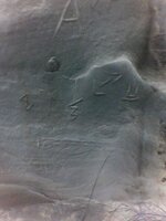
I see this just as an over all confirmation marker, now the S and the 218 could very
well be a compass heading- so keep that in mind.

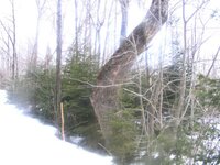
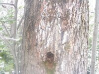
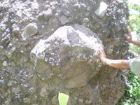
Go back to the stone markers, a turtle, or fish, etc, this will direct you to the triangle
mostly designated by a very large and old tree, some not native to the Phils.
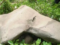
Some of the triangle points may be half buried rocks. Take photos of all boulders
and rocks at high noon, or so and look for shadows.

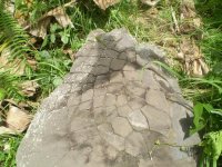
Regarding your photo, again I agree with Old Dog it does look like Roman Numerals,
however I dont see anything to confirm that this is not natural, since I see it out of
context to other marks.

A suggestion is to stand at the cement post marker and take the compass heading to
the Roman Numeral stone and see if that heading is 218 degrees? If so this would
be your needed confirmation marker.

More pics of the other monuments if you can , will help unravel your puzzle!
auriferiously
rangler


"persistence pays"
 

My Precious

Sr. Member
Feb 10, 2009
289
18
Adirondack Mountains
Detector(s) used
Minelab Sovereign GT
Primary Interest:
All Treasure Hunting
I've only been a member of TNet for probably a month now and I've poked around quite a bit in all the different threads. I've learned quite a bit from the knowledge of so many people at TNet it's amazing, but this site in particular has me intrigued. I get out quite a bit in the woods snowshoeing in the winter, hiking mountains in the summer, and I live in the Adirondacks of NY so there's plenty of it but now I find myself looking at trees and rock formations like I didn't before, I'm always checking for markers/signs. I'm posting a couple pictures of a tree that I've always noticed as oddly shaped, any chance of this being a marker of some kind? Took the pics just today while out snowshoeing, it has a sharp bend and what looks like a face or animal (buffalo?)head to me. Hopefully I'll get an opinion or two.
 

Attachments

  • tree right bend.jpg
    tree right bend.jpg
    72.8 KB · Views: 1,574
  • tree face.jpg
    tree face.jpg
    80.9 KB · Views: 1,943
OP
OP
rangler

rangler

Bronze Member
Jul 12, 2004
1,320
200
The Land Of The Free Because Of The Brave!
Detector(s) used
for solutions to the jesuit code -email pics to: [email protected]


;[email protected] locations needed! oro bro!
Primary Interest:
Other
j.raud
Welcome to the forum and thanks for posting your pic......
The tree itself , in terms of age is the first thing you want to look at.
This tree looks no older than 50 years - at the very most, even for a slow
growing hard wood, north of the softwood zone, that runs south
of the mid-state in Pennsylvania.
That puts the tree as a sapling in the mid 1940's, if a great snow fall
buried this tree, and deformed it all winter long , and later in the spring
the snow melt would release the tree but it would still be deformed.

I think that is what you have here., the hole in the tree at the depressed
area could be where the branch, was broken when the tree was jammed
into the ground.

What I would do, is to go in the direction of the pointed part and see what
you can see.. if it leads to water, or a rock out cropping or a likely camp
spot. This will help you determine if it is just a freak of nature or a pointer

It is defiantly not Jesuit, it could be KGC ....if there is some metal items buried
around the tree or in the direction of the point, Look for rocks and boulders
that might have marks carved on them, before you dismiss this one!

That is what I would do, if it were me and I came across this ... the other thing
kinda obscure, you can take a bore sample to double check the age of the tree
but I bet you a can of chain saw oil that it is not over 50 years old.

Keep your eyes open in the woods and keep reading all the awesome theads here
treasurenet/
auriferiously
rangler

....."oh how the hidden things are sought up"
 

My Precious

Sr. Member
Feb 10, 2009
289
18
Adirondack Mountains
Detector(s) used
Minelab Sovereign GT
Primary Interest:
All Treasure Hunting
rangler said:
j.raud
Welcome to the forum and thanks for posting your pic......
The tree itself , in terms of age is the first thing you want to look at.
This tree looks no older than 50 years - at the very most, even for a slow
growing hard wood, north of the softwood zone, that runs south
of the mid-state in Pennsylvania.
That puts the tree as a sapling in the mid 1940's, if a great snow fall
buried this tree, and deformed it all winter long , and later in the spring
the snow melt would release the tree but it would still be deformed.

I think that is what you have here., the hole in the tree at the depressed
area could be where the branch, was broken when the tree was jammed
into the ground.

What I would do, is to go in the direction of the pointed part and see what
you can see.. if it leads to water, or a rock out cropping or a likely camp
spot. This will help you determine if it is just a freak of nature or a pointer

It is defiantly not Jesuit, it could be KGC ....if there is some metal items buried
around the tree or in the direction of the point, Look for rocks and boulders
that might have marks carved on them, before you dismiss this one!

That is what I would do, if it were me and I came across this ... the other thing
kinda obscure, you can take a bore sample to double check the age of the tree
but I bet you a can of chain saw oil that it is not over 50 years old.

Keep your eyes open in the woods and keep reading all the awesome theads here
treasurenet/
auferiously
rangler

....."oh how the hidden things are sought up"

Thanks Rangler for the response!! It's very possible this tree isn't much older than 50 years although it is one of the bigger trees along this trail. Next time I'm up that way I'll take a right off the trail and into the woods to see what I find, although the snow is still kinda deep in spots. I'm not really sure what KGC stands for, can I have an explanation on that? Oh and I'm in the Adirondack mountains so I don't think it's a water marker, there's brooks, rivers, lakes, ponds, you name it ...it's everywhere. There is only 15 - 20 miles away what is called the Ganienkeh territory...a 700 acre parcel belonging to the Mohawk indians, I was thinking maybe a connection. One more question, how far would the next marker be if there was one?
 

Old Dog

Gold Member
May 22, 2007
5,860
397
Western Colorado
If it is KGC (Knights of the Golden Circle) The distance between markers could be as much as a couple miles.
If not...
Who knows?

Sorry to be a pessimist.
But the truth is best delivered up front.

Show me more signs ....
change my mind for me

Thom
 

krugger

Greenie
Jul 7, 2006
19
1
any help? picture of turtle's back. before other group of treasure hunter pulverized the other part of the boulder, the turtle has a head facing South, with 4 feet and a tail. thanks

krugger
 

Attachments

  • site 45d.JPG
    site 45d.JPG
    73.4 KB · Views: 2,378

krugger

Greenie
Jul 7, 2006
19
1
2nd pictures same site/location with turtle boulder. the turtle boulder facing this heart boulder with huge slanting hole MOL 1ft. the distance from turtle boulder to heart boulder MOL 100 meters.
 

Attachments

  • site 45b.JPG
    site 45b.JPG
    46 KB · Views: 1,321

krugger

Greenie
Jul 7, 2006
19
1
3rd picture stone with diameter MOL 1ft attached or inserted in the side of huge mixed with gravel and sand boulder facing NE. same location with other 2 boulders the heart & turtle boulders. if you looked the aireal view of these three boulders it forms into triangle with unequal distance. thanks


krugger
 

Attachments

  • site 45c.JPG
    site 45c.JPG
    42.7 KB · Views: 1,559

Old Dog

Gold Member
May 22, 2007
5,860
397
Western Colorado
If you are inclined to work "by the book".
Measure from the line under the T to the ground ...
Multiply that distance X 10 and dig that deep.

These are Kenworthy's directions.


Rigmover,

sorry to sound so sarcastic.
They are some well carved signs.
A straight answer can't be formed untill a full view of the signs is known.
they must be in order as well.
 

rigmover2307

Jr. Member
Apr 20, 2009
97
3
bloomfield nm
Old Dog said:
Measure from the line under the T to the ground ...
Multiply that distance X 10 and dig that deep.


sorry to sound so sarcastic.
They are some well carved signs.
A straight answer can't be formed untill a full view of the signs is known.
they must be in order as well.
thanks, on the digging part, pretty much all the signs iv come across here are about the same high relief different colors and whatnot. i have never seen them so light as some of the ones posted on here. i travel sometimes hundreds of dirt miles a day in about three counties, in and out of the canyons moving drilling rigs around. the s/s are in that kind of shape for the most part for this whole area
 

Old Dog

Gold Member
May 22, 2007
5,860
397
Western Colorado
Here is a better view of your top picture.
The A may be a part of the whole thing.
There is a lot more here than you are seeing.

The hourglass says a days travel, go to the right at 90 degrees from these marks.
the trail does have inherent danger. more marks to the right about ten varas away. + or - 33 feet.

This is what this says.
 

Attachments

  • index.jpg
    index.jpg
    31.7 KB · Views: 1,235

rigmover2307

Jr. Member
Apr 20, 2009
97
3
bloomfield nm
Old Dog said:
Here is a better view of your top picture.
The A may be a part of the whole thing.
There is a lot more here than you are seeing.

The hourglass says a days travel, go to the right at 90 degrees from these marks.
the trail does have inherent danger. more marks to the right about ten varas away. + or - 33 feet.

This is what this says.
very nice, and to the point. although there are no more marks on that western face, however, up and to the right over the ridge are markings indicating three days travel north. probably a hundred yards or so from these markings.

i was just curious as to how someone other than myself and two others here interpeted those. i was hoping that perhaps they were off by 180 as a reservation boundary prevents further research.
 

Old Dog

Gold Member
May 22, 2007
5,860
397
Western Colorado
So the distance was greater than 10 varas
turned out to be 100. Good for you... persistance pays off.

just a small idea...


I am told that a hunting permit trumps that boundary.
Check with the Game warden to know for sure.
Be safe.


Thom
 

rigmover2307

Jr. Member
Apr 20, 2009
97
3
bloomfield nm
Old Dog said:
So the distance was greater than 10 varas
turned out to be 100. Good for you... persistance pays off.

just a small idea...


I am told that a hunting permit trumps that boundary.
Check with the Game warden to know for sure.
Be safe.


Thom
working on a rumor about a fifteen dollar annual antler collecting permit. cause who dosent like to do that? ;D
 

OP
OP
rangler

rangler

Bronze Member
Jul 12, 2004
1,320
200
The Land Of The Free Because Of The Brave!
Detector(s) used
for solutions to the jesuit code -email pics to: [email protected]


;[email protected] locations needed! oro bro!
Primary Interest:
Other
Thom
good solve there bud, appreciate the lesson too!
As for the "A" not only is it the largest sign here
(which hints at 'start here') it has a longer leg pointing to the
hours glass as you pointed out, this simply means
to start at the hourglass to read the sign, which
you did very well, thanks again!
mi casa su casa
rangler


O1 "How are the things of Esau searched out! how are his hidden things sought up!"..... Obadiah 1:6
 

OP
OP
rangler

rangler

Bronze Member
Jul 12, 2004
1,320
200
The Land Of The Free Because Of The Brave!
Detector(s) used
for solutions to the jesuit code -email pics to: [email protected]


;[email protected] locations needed! oro bro!
Primary Interest:
Other
I think that is is prudent to post some information about how to recognize a verified Alpha
or Omega Monument, so that folks can recognize them for what they are, photograph
them correctly and then hopefully post them here for additional help if they need it.


Some basics, begin at the beginning....

Confirmation, yes I am hung up confirmation because it is THE way to know......

A. That I have a real Monument, so I don't chase ghosts or cloud reading type signs.
B. The confirmation also give hints as to what to look for at the Omega
C. Many false trails and monuments are avoided by looking for confirmation of each step
D. The Jesuits never left you hanging, taking you from one confirmed sign to the next confirmed sign.

So what makes up Confirmation signs? Well for me and my understanding the most common are:

1.The Hoyo- the hole or opening in the Alpha Monument that you can see the sky through.
At the Omega you will find hoyos that you see dirt through, this may be the dig here sign.
2. Human or Animal faces, mostly in profile but other aspects as well.
3. Numbers and Letters, number can mean compass headings, letter specific roman numerals
or specific instructions like the letter 'A'.
4. Bible verses usually are in form of Letter and Numbers like D4, P8, and O16
5. Shadow signs, every Alpha I know of confirms itself with the very important shadow sign.

omega hoyo1.JPG
(â“’2007 all right reserved-this mushroom omega hoyo is a perfect example - the mushroom means cache!

Remember than the Code Makers knew that the background of rocks and boulders can make things
look like an animal head or a turtle or a Indian or monkey head, but without a confirmation sign
these are just natures handiwork, nice to look at, fun to photograph but not much more than art
in terms of what they can be used for.
I think is was Thom (old dog) who coined the term 'matrix' in this regard,
as a great definition of what these type of 'signs' are..the natural crack, weathered shapes, or the
natural phantasmagorical shapes of volcanic tuff, granite or sandstone, may give naturalistic shapes
that make things look like shapes, faces, things, but it is the background camouflage that the Jesuits
and Spanish and other used on purpose to fool you and I.
To separate out this background camo, the confirmation mark is the key! Look for the hoyo..I would
say that if you don't find a hoyo about 90% of the time..it is NOT a certified Monument! The things that
override the absence of a hoyo, are numerous faces, shadow signs, numbers and or letters.
Sad to say much of what is posted here and else where are just imagination , nothing more.

The hard fast rule about proper photographing your monuments is as follows...
a. Pick the right time, High Noon is the best, an hour either way is ok
the very important shadows do not 'blossom' until the sun is high

b. Stand with your back to the sun..keep your shadow and other things
like trees, other rock shadows ect, out of the shot.

c. Use a 5 megapixel or greater digital cam, because you want to Zoom in
on your pics and crawl over each square inch of that rock, looking for the
very important hidden number, letters, faces ect that not only give confirmation
but more clues to the solution of Distance and Direction.

auriferiously
rangler

"..the truth is better delivered upfront"...old dog
 

Top Member Reactions

Users who are viewing this thread

Top