The True Story of Victorio Peak

somehiker

Silver Member
May 1, 2007
4,365
6,426
Primary Interest:
All Treasure Hunting
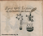
That one is from a page of the Florentine codex, a Quetzalcoatl warrior.
Although there are only six circles on the staff, they may denote 6 places of importance.
If so, then why has one more been added to the staff/standard on the map ?
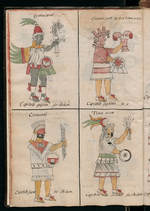
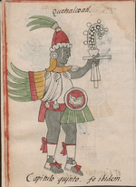
32sm.png Quetzalcoatl warrior  FC.png

Florentine Codex - Wikipedia, the free encyclopedia

I find this codex to be the most interesting of them all, because within it's 729 pages it contains a history of the conquest of Tenochtitlan, including the events surrounding the rebellion, the death of Moctezuma and the subsequent "La Noche Triste". Also the recovery of the Aztec treasure and Moctezuma's body from the lake, along with the disposition of both....
 

Last edited:

somehiker

Silver Member
May 1, 2007
4,365
6,426
Primary Interest:
All Treasure Hunting
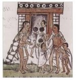
Another depiction of the same type.
I haven't been able to accurately translate the description as yet.
Appears to be hispanicized nahuatl of some kind.
I'll run it by a co-worker from Guatemala tomorrow.

FC P36.png
 

Last edited:

sdcfia

Silver Member
Sep 28, 2014
3,660
8,886
Primary Interest:
Other
That one is from a page of the Florentine codex, a Quetzalcoatl warrior.
Although there are only six circles on the staff, they may denote 6 places of importance.
If so, then why has one more been added to the staff/standard on the map ?

The symbol represents the Ursa Major constellation. You can research its symbolic relationship with the god. The Florentine Codex was created by Spaniards, who misinterpreted and/or omitted much throughout, including the seventh star in this particular depiction.
 

somehiker

Silver Member
May 1, 2007
4,365
6,426
Primary Interest:
All Treasure Hunting
The symbol represents the Ursa Major constellation. You can research its symbolic relationship with the god. The Florentine Codex was created by Spaniards, who misinterpreted and/or omitted much throughout, including the seventh star in this particular depiction.

Welcome to T-Net sd.
Yes, Ursa Major did play an important role in the cosmology of the Aztec. I have researched the constellations that were important to them, and Tezcatlipoca, and this is one of the reasons I noticed the similarities between their artwork and that of the map being discussed. While it's true the Spanish did misinterpret much of the history and mythology of the natives, the art was created by natives who were not art novices, nor were they ignorant of their own history. I would put more trust in what they said, or even what those who created the original codices had to say at the time, than what modern day self-proclaimed experts have to offer.
When you say "seventh star" I presume you are saying that star (polaris) was omitted from the drawing(s) in the codex. Perhaps if, as you seem to be saying, the six circles represent stars, then the seventh is actually present on the gourd (?) which forms the bottom of the "staff" in the second depiction I posted. It is also present as the seventh circle on the map, which may be relevant to the map itself because it represents North, the direction in which some believe the Aztec treasures were taken. As I pointed out, the snake is bordered by seven circles, rather than the six shown on the staff of the first image from the codice.
While it is undoubtedly true that de Sahagun as well may have made mistakes of interpretation during his 50 years of devotion to the study of the Aztec, I believe his total of twelve volumes contain the best information we are likely to ever have for study and research......http://en.wikipedia.org/wiki/Bernardino_de_Sahagun ......unless of course a Cronica X happens to turn up somewhere .

Regards:SH.
 

Last edited:

sdcfia

Silver Member
Sep 28, 2014
3,660
8,886
Primary Interest:
Other
Welcome to T-Net sd.
Yes, Ursa Major did play an important role in the cosmology of the Aztec. I have researched the constellations that were important to them, and Tezcatlipoca, and this is one of the reasons I noticed the similarities between their artwork and that of the map being discussed. While it's true the Spanish did misinterpret much of the history and mythology of the natives, the art was created by natives who were not art novices, nor were they ignorant of their own history. I would put more trust in what they said, or even what those who created the original codices had to say at the time, than what modern day self-proclaimed experts have to offer.
When you say "seventh star" I presume you are saying that star (polaris) was omitted from the drawing(s) in the codex. Perhaps if, as you seem to be saying, the six circles represent stars, then the seventh is actually present on the gourd (?) which forms the bottom of the "staff" in the second depiction I posted. It is also present as the seventh circle on the map, which may be relevant to the map itself because it represents North, the direction in which some believe the Aztec treasures were taken. As I pointed out, the snake is bordered by seven circles, rather than the six shown on the staff of the first image from the codice.
While it is undoubtedly true that de Sahagun as well may have made mistakes of interpretation during his 50 years of devotion to the study of the Aztec, I believe his total of twelve volumes contain the best information we are likely to ever have for study and research......Bernardino de Sahagún - Wikipedia, the free encyclopedia ......unless of course a Cronica X happens to turn up somewhere .

Regards:SH.

It's unfortunate de Sahagun wasn't able to prevent so much of the Aztec cultural source material from going up in smoke. He did a fine job, yes, but it seems quite risky to me to put excessive faith in the Florentine document. Likewise, I agree that modern interpretors are probably even more limited. The vanquished are seldom given an unedited voice.

Why there are only six stars in the object being held by Quetzalcoatl is anybody's guess. Maybe the object represents a different constellation. Maybe it's a mistake in interpretation. Maybe the object is something else entirely. Polaris is not one of Ursa Major's seven stars, but it is one of Ursa Minor's, another seven star constellation. The treasure map obviously means to link some North American sites to the Aztecs, but the map's origins are unknown, as is the whereabouts of the original chart. I am of the opinion, as are others here too, apparently, that the map's link to the Noss family creates significant doubt.
 

somehiker

Silver Member
May 1, 2007
4,365
6,426
Primary Interest:
All Treasure Hunting
It's unfortunate de Sahagun wasn't able to prevent so much of the Aztec cultural source material from going up in smoke. He did a fine job, yes, but it seems quite risky to me to put excessive faith in the Florentine document. Likewise, I agree that modern interpretors are probably even more limited. The vanquished are seldom given an unedited voice.

Why there are only six stars in the object being held by Quetzalcoatl is anybody's guess. Maybe the object represents a different constellation. Maybe it's a mistake in interpretation. Maybe the object is something else entirely. Polaris is not one of Ursa Major's seven stars, but it is one of Ursa Minor's, another seven star constellation. The treasure map obviously means to link some North American sites to the Aztecs, but the map's origins are unknown, as is the whereabouts of the original chart. I am of the opinion, as are others here too, apparently, that the map's link to the Noss family creates significant doubt.

If everything was a slam dunk, we wouldn't have much to look for.
The presence of a single star on the "gourd" seems to indicate something of importance. Which is why I consider it as possibly referring to Polaris.
That the codex image also has six circles bordering the symbol, with what may or may not be stars within them. I suspect they may symbolize places, perhaps villages, holy places, or yes even stars as you claimed they did in your post. If they do, then Ursa Minor and Polaris seems the more likely of the two.
There are many genuine and valuable antiquities being recovered from people of dubious reputation on an annual basis. I, along with many other researchers aren't so quick to dismiss them on that basis alone.

Regards:SH.
 

Last edited:

somehiker

Silver Member
May 1, 2007
4,365
6,426
Primary Interest:
All Treasure Hunting
So, how about posting the docs .
Might be something good in those, linking him with other folks.
 

somehiker

Silver Member
May 1, 2007
4,365
6,426
Primary Interest:
All Treasure Hunting
There are problems with the map, perhaps due to it being the end result of a progression of copies.
What intrigues me, is that based on the artistic style, it may have originated as a copy of part of a codex.
The other two drawings posted by NP at the same time were also interesting for similar reasons.
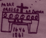
I have doubts though, about all of the words,names and dates on the map. Were these added to this copy by someone familiar with the Tayopa stories, perhaps Noss, because he thought the map was a connection between Tayopa and the Caballo's ?

The "mission" on the map looks more like an Aztec building to me Joseph.
No mention of that in the Tayopa story, is there ?

aztec school.jpg building.png

This is a depiction of an Aztec school.
Pre-colonial Codices were probably used in schools.
 

Last edited:

UncleMatt

Bronze Member
Jul 14, 2012
2,389
2,530
Albuqerque, NM / Durango, CO
Detector(s) used
Garrett Infinium & Gold Bug II, Bazooka Super Prospector Sluice
Primary Interest:
All Treasure Hunting
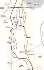
I would also like to add, this map is not enough to get you to a specific location, unless you already know your way. It may get you to a general area, but it lacks detail and perspective at the proper scale for it to take you right to a point on the land. Of course, you may disagree, and I would then ask you to show what specific points on the map are indicated by the 2 triangles. In my opinion only an approximate destination could be discerned. Which probably means, there is another part of this map to show local specifics to the site itself.
 

Nov 8, 2004
14,582
11,942
Alamos,Sonora,Mexico
Primary Interest:
All Treasure Hunting
Hi unc Matt; Since I already Have 'Tayopa' it is sorta back tracking. The story of the Caballos ,and a few small finds that can be proven, etc is the first evidence outside of my Tayopa zone and confirms them and my seculations on why.and where.
 

UncleMatt

Bronze Member
Jul 14, 2012
2,389
2,530
Albuqerque, NM / Durango, CO
Detector(s) used
Garrett Infinium & Gold Bug II, Bazooka Super Prospector Sluice
Primary Interest:
All Treasure Hunting
I'm just speculating we may be missing a piece of this map, and I'm more referring to the end of the map where it supposedly shows Victorio Peak as a cache point.
 

Last edited:
Nov 8, 2004
14,582
11,942
Alamos,Sonora,Mexico
Primary Interest:
All Treasure Hunting
S Hiker, Padre Orosco is well established with Tayopa in it's ealiest day - the Indian uprising and their hiding of
Tayopa. Since I have already found & own Tayopa I have a disrinct advantage in interpreting old maps.
 

Nov 8, 2004
14,582
11,942
Alamos,Sonora,Mexico
Primary Interest:
All Treasure Hunting
Hey people, look whr I found
######

The folowing is from

Treasure Hunting

The Best Treasure Hunting Blog on the net [email protected]


Pedro Navarez and the Caballo Mountains

Mexico City
Convent of St. Augustine
February 5, 1650

“Ask in Paso Del Norte where the Caballo Range is. You will find it four days by horse at a good pace up the river and not very far therefrom. Most of these mountains are of equal height and they have two large passes and a small amount of juniper trees. Coming along the King’s Highway (El Camino Real) from the pass, one will see on the left a range of mountains [this is after crossing the river at the pass and entering upon the first leg of the journey], to the right a flat plain (Jornada del Muerto) where the naked eye cannot circumscribe. There is a small hill a great distance from the road. [This is the point of the rocks] These marks you will find to your right where the point of the compass points to the sunrise. This range has two wide gaps which end in two arroyos, one running in the direction of the sunrise and the other toward sunset. The two have many ash trees, one having more than the other. In the gap where the sun rises, look for a small spring. The gap is not very big, a city could be built in the plain. The spring is not far from this gap, and it is well covered with juniper trees, stones, earth and large and small rocks on top. Look carefully at this spring, for it contains great riches. You can take out much gold beneath its surface. And from this spring count 250 varas toward the brow of the mountain, keeping to the level ground. Here you will find a stone with a very large cross chiseled upon its face. The stone is not of this region, having been brought in by mule train. From this point, count 100 varas and examine a small piece of ground closely. It has a few rocks so look carefully at its condition. Here you will find silver bars, there should be 18 atajas. Remove the boards under the bars and take 11 more atajas in finished silver. These marks are to the right before entering the gap, at the point of the compass where the sun rises. When you have finished this work, return to the spring in order that you may climb the mountain to your left. You will look for a very deep cave. There are 90 atajas of silver buried in this cave. I warn you to be careful and not to make a mistake for there are two other caves, but this one is the deepest of the three. The three are where the sun sets and I must tell you that there are some smaller caches and little springs, but all of them have been covered. And if any of these markings should be destroyed, then proceed with the utmost care in carrying out of the task. Return to the spring and climb the mountains to the right in the direction of the rising sun. Not very high up you will find a high rolling mesa, a placer, Here you can cut the copper with an axe and I believe that the spring comes from here. Other signs you will also find. In some places, painted figures with many writings engraved in copper. Therefore I urge you to search well for these marks. Thousands of families would be helped thereby.”

This is a letter in it’s entirety that was written to a padre in Mexico City by Pedro Navarez, also know as El Chato. El Chato was a Spanish deserter who spent his time robbing the Spanish mule trains of their own plunders. It is estimated that over the ten years of plundering the treasure trains of the Spanish, Pedro Navarez stole and hid treasure that today would be worth one hundred million dollars or more. This guy new how to steal!

Pedro began his illustrious career around 1639 and lasted until 1649 when he and his band of thieves were either caught or killed. His band of merry men were considered to be ruthless predators and extremely dangerous and very costly to the Spanish government. After being captured by the Spanish Pedro confessed to burying more than 20 caches of treasure during his ten year career. He apparently told the Spanish where a few of these were however, while waiting in jail for his death sentence to be carried out Pedro wrote the above letter to a padre so that some his spoils might be used for good. I guess maybe he was trying to atone for his past indiscretions?

In case you are wondering, an “ataja” is said to be a string of approximately eight mules. If a mule can carry a minimum of 135 pounds and you have eight mules per ataja then that would mean you are talking about over 1000 pounds of silver per ataja. In his letter Pedro said he hid a total of 119 atajas of “finished silver” bars. This would be more than 119,000 pounds of silver!! How much is silver going for today?

(Just out of curiosity, I checked and the price of silver is $15.81 per ounce. So 119,000 pounds would have 1,904,000 ounces. At $15.81 per ounce you are talking about $30,102,240.00. I’d say that’s worth a hike or two into the New Mexico mountains!)
Posted by Ron at 12:03 PM
Email ThisBlogThis!Share to TwitterShare to FacebookShare to Pinterest
No comments:

Post a Comment
Newer Post Older Post Home
Subscribe to: Post Comments (Atom)
map
 

somehiker

Silver Member
May 1, 2007
4,365
6,426
Primary Interest:
All Treasure Hunting
Jamie has a ton of good treasure stuff on his blog.
It's well worth checking out. He has one on the Santa Ritas and Tumacacori as well.
I don't have time to look it up right now though.
 

sdcfia

Silver Member
Sep 28, 2014
3,660
8,886
Primary Interest:
Other
Pedro Navarez and the Caballo Mountains

Mexico City
Convent of St. Augustine
February 5, 1650

“Ask in Paso Del Norte where the Caballo Range is. <cut>"

Pedro Navarez ("El Chato") was a noted bandit active in Chihuahua, Mexico, in the early 1800's. Much folklore surrounds his memory as a Robin Hood character who cached robbery proceeds all over the Satevo-Parral-Delicias country south of Chihuahua city. Reports of his death are highly romanticized in Mexico, but the waybills to his treasures were apparently disclosed by his daughter in the 1840s and consisted mainly of coins buried in clay pots on several ranches. There is little reason to believe he was in New Mexico, where the pickings for roadside bandits were very slim along the Rio Grande, especially compared to the riches available in Chihuahua at the time.

The famous New Mexico Navarez waybill has many variations, and as can be seen from the above quoted example, are fraught with egregious errors. First, the time period is wrong by 200 years. Second, in the 17th century, there was no mountain range upstream from Paso del Norte known as the Caballos. That's two amateurish mistakes by the time the first sentence is read. That's about all a fact checker needs to close the book on this story. The Caballos are an interesting subject, but Navarez doesn't belong in the conversation.
 

Last edited:
Nov 8, 2004
14,582
11,942
Alamos,Sonora,Mexico
Primary Interest:
All Treasure Hunting
S Hiker. The reason that I have a distinct advantage is that the Tayopas co-ordinates, VC and the Cabollos are well known, '

so we have a map with two known points with a crudely drawn trails connecting them, 'yes'. it IS a genuine map. but o whose handiwork and when? There are many questions remaining, but it has done it's intended work already. and well.


Co-ord.jpg - - - 32*55 N, 106* 38'24W
 

Rawhide

Silver Member
Nov 17, 2010
3,590
2,185
SouthWestern USA
Detector(s) used
Nox 800, Etrac, F75, AT Pro. Last two for sale.
Primary Interest:
All Treasure Hunting
My first visit to the Cabbalo's to fish had me looking at the mountain the whole time. It calls to you. You can see where great statues once stood, old mine workings, and old trails that are not used anymore. Ted Turner has a ranch opposite of where I was and I would love to visit if it is allowed some day before I die. Many stories exist about the area and there has been silver found there for sure. A good friend Nick Flemming actually has a few mining claimsin the area and I was invited to visit. I held some of the ore and a silver bar in my hands. He has some great videos, one of a shaft with tunnels in it that is awesome to watch. Access to the area is a bit of a puzzle but is doable. You will need a good strong vehicle with high clearance to explore the many trails. The fishing is great there too, but the water is off for the season now so you will want to stick to the lakes. You can acces most of the Rio Grande banks by cattle gates off the old highway and make camp. There is a campground for rv's there close by too. Im not sure how much is State Park and how much is BLM so check the regs before you break out that 4 wheeler.

While the old proper names have not been used. I do believe many have visited the area in search of treasure. The story about Pedro Navarez has always been with me when I hunt. Every now and then someone will post a clay pot of coins found. I believe it is a true story that may be embellished a bit.
 

Last edited:

Top Member Reactions

Users who are viewing this thread

Top