Interesting Old Maps

whiskeyrat

Hero Member
May 7, 2012
539
1,246
mid Michigan
Primary Interest:
Prospecting
I purchased a cd of old New Mexico Maps.
Its interesting to see how the mountain ranges names moved around from the period of 1800 to 1877.
Kinda seems like if your reading a treasure tale that happened in lets say 1863, and mentions the caballo mountains, you might have to reference a map from 1863 to make sure where the "caballo" mountains were at that time.
The major ranges seem to move around.
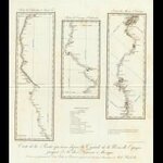
Anyway, attached is the maps of 1807 showing the "countries" in northern Mexico and the route and existing villages etc up the Rio Grande to Santa Fe.
Hopefully these will show up and be "seeable"? have not tried this before.
hmmm, seems to be too large its 6.5 mb as a pdf
enjoy
wr
 

OP
OP
whiskeyrat

whiskeyrat

Hero Member
May 7, 2012
539
1,246
mid Michigan
Primary Interest:
Prospecting
0328008_thumb.jpg
thumbnail might not be useable
 

OP
OP
whiskeyrat

whiskeyrat

Hero Member
May 7, 2012
539
1,246
mid Michigan
Primary Interest:
Prospecting
anyone know what is the max size for a pdf? so that it can been seen and zoomed in etc?
 

Dr. Syn

Sr. Member
Feb 15, 2011
458
700
Lakeland, Florida
According to the drop down box for attachments, its 33.38MB for a PDF.


And yeah places change names with the folks who are there at the time. Even more recent, at least where I used to live. Places were referred to as to the property's owners name. 50 years later many of those folks are long gone, and the people now living in the area have no clue when you talk about it. My sons have no clue if I talk about such and such place, yet talk to an old timer and they know it with clarity.

Funny reminds me of an old cache legend I tracked down. All the stories stated a little town not spitting distance from my farm.
When I actually delved into the story, one thing hit me immediately, who the person was. Growing up in a small farm area you knew everyone in the area. And this guy was unknown. So I dug deeper and found out the true story was actually 60 miles away, and it wasn't even a town, it was an area outside of a major town. Once I found that, it didn't take long to track down newspaper articles proving the cache, and about 15 minutes to locate the property.

But goes to show, when looking for a treasure legend you really need to get the facts and not the stories.
 

OP
OP
whiskeyrat

whiskeyrat

Hero Member
May 7, 2012
539
1,246
mid Michigan
Primary Interest:
Prospecting
i will keep trying to get the pdfs to load. there are very interesting.
another feature that makes it difficult to pick off coordinates, is that some of the early maps give latitude and longitude from "washington". I assume to be Washington DC. that could mess you up real bad.
 

UncleMatt

Bronze Member
Jul 14, 2012
2,389
2,530
Albuqerque, NM / Durango, CO
Detector(s) used
Garrett Infinium & Gold Bug II, Bazooka Super Prospector Sluice
Primary Interest:
All Treasure Hunting
When I got to upload images in threads, I'm not seeing an option to upload pdf's. "Allowed Filetypes: jpg, jpeg, png, gif"
 

OP
OP
whiskeyrat

whiskeyrat

Hero Member
May 7, 2012
539
1,246
mid Michigan
Primary Interest:
Prospecting
When I got to upload images in threads, I'm not seeing an option to upload pdf's. "Allowed Filetypes: jpg, jpeg, png, gif"

yes i ran into that also. maybe that is why my maps will not load. they are about 6mb which is below the limit mentioned above.
maybe tnet can change its format to allow pdf files????
wr
 

OP
OP
whiskeyrat

whiskeyrat

Hero Member
May 7, 2012
539
1,246
mid Michigan
Primary Interest:
Prospecting
i did not put that exasperated looking emoticon in my post above. it just appeared.
 

OP
OP
whiskeyrat

whiskeyrat

Hero Member
May 7, 2012
539
1,246
mid Michigan
Primary Interest:
Prospecting
According to the drop down box for attachments, its 33.38MB for a PDF.


And yeah places change names with the folks who are there at the time. Even more recent, at least where I used to live. Places were referred to as to the property's owners name. 50 years later many of those folks are long gone, and the people now living in the area have no clue when you talk about it. My sons have no clue if I talk about such and such place, yet talk to an old timer and they know it with clarity.

Funny reminds me of an old cache legend I tracked down. All the stories stated a little town not spitting distance from my farm.
When I actually delved into the story, one thing hit me immediately, who the person was. Growing up in a small farm area you knew everyone in the area. And this guy was unknown. So I dug deeper and found out the true story was actually 60 miles away, and it wasn't even a town, it was an area outside of a major town. Once I found that, it didn't take long to track down newspaper articles proving the cache, and about 15 minutes to locate the property.

But goes to show, when looking for a treasure legend you really need to get the facts and not the stories.

where do you find the pdf download info? I do not get that choice. Maybe its because your a full member and i am just a junior member?? maybe i am limited to jpg????? I cant seem to find any "rules" for the sight that explains??
 

AbTexEx

Full Member
Nov 27, 2008
206
246
America's Dairyland
Primary Interest:
Prospecting
PDF has to be an "Attachment"
When you post, on the bottom right it says Go Advanced.
Hit that and scroll down to Manage Attachments
Mine.JPG


The red circle next to the file says To Big
 

Attachments

  • Instruction Manual XT18000_Scan.pdf
    737.6 KB · Views: 320
  • 2big.JPG
    2big.JPG
    81.6 KB · Views: 433
Last edited:
OP
OP
whiskeyrat

whiskeyrat

Hero Member
May 7, 2012
539
1,246
mid Michigan
Primary Interest:
Prospecting
PDF has to be an "Attachment"
When you post, on the bottom right it says Go Advanced.
Hit that and scroll down to Manage Attachments
View attachment 1174046


The red circle next to the file says To Big

Ok thanks for the advice.
I tried that got to attachments and it does say mas pdf size is 33mb. my map attachment in only 6.57 mb.
You first have to upload it and then you can drag and drop as attachment, and it will not upload.
If i try and upload it gives me the red circle too big.
i can select basic uploader, then it does not say too big, but just cranks and cranks and then nothing happens.
I have a lot of maps it would be nice to share and get opinions and discussion etc.
Maybe they are protected some how and cant be displayed like this????
 

OP
OP
whiskeyrat

whiskeyrat

Hero Member
May 7, 2012
539
1,246
mid Michigan
Primary Interest:
Prospecting
A couple of these old maps show "Padre Silver Mine" on them.
They dont say which Padre, but i thought it must be a major mine to be showing up on maps in the late 1700s and early 1800s.
Its near El Paso.

They also show a "Lagoon Del Muerto" that appears to be a lake that was east of the present day Caballos maybe somewhere east of Polamas Gap.
Between the Caballos and the RR.
Must have dried up since then.
Hard to tell exactly where with lattitude and longitude displayed relative to "washington".

Also a "city or town or wagon depot" of San Diego shows up on a lot of them that seems to be somewhere a little north of current day Rincon or Hatch where there is nothing today.
Seems to be a major wagon route stop prior to the RR but on the east side of the Rio Grande, not on the west side like all the towns today.
 

AbTexEx

Full Member
Nov 27, 2008
206
246
America's Dairyland
Primary Interest:
Prospecting
Tried to upload several PDF's. Largest that would take was around 4 mb. I'm using Win 7 and 8.1. They both have snipping tool to make a JPEG of the screen. Not very HiRez but it works.

Word of warning about the Caballos. If you need spare parts for quads, motorcycles and 4x4 trucks, just wander some of the canyon bottoms till you find what you need. Keep a wary eye for incoming vehicles and their riders adding to the collection.


AJones
 

Dr. Syn

Sr. Member
Feb 15, 2011
458
700
Lakeland, Florida
WR if you hit the question mark multiple times in a row the system automatically makes an emoticon. ????

Just did it for me.

And I just tried loading a 30mb PDF file. Lets see if it works for me. Has nothing to do with treasure but it was one I had around 30mb.
 

Attachments

  • Trimming an aircraft.pdf
    29.3 KB · Views: 352
Last edited:
OP
OP
whiskeyrat

whiskeyrat

Hero Member
May 7, 2012
539
1,246
mid Michigan
Primary Interest:
Prospecting
View attachment 1807 map snap shot001.pdf
no matter what i try it says "upload failure" after cranking for about 30 seconds.

so i printed a snap shot of a small area of this map. then scanned it to get reduced to 546 kb. then it uploads.

not sure if the resolution will be good enough to be useful.
this is a snap shot of a small area of the map around the area of the caballos

lets see if this displays and is useful.
 

OP
OP
whiskeyrat

whiskeyrat

Hero Member
May 7, 2012
539
1,246
mid Michigan
Primary Interest:
Prospecting
lets try another one.

View attachment 1070017 360 res map pima villages to ft wingate001.pdf

i reduced this one to 1.2 mb and it uploaded ok.
except i think it needs to be rotated to view.

this is from a 1866 map. shows from the Pima Villages to Ft. wingate. i will put this on the adams diggins thread also.

the orange blotches are gold mines, the blue blotches are silver mines, the green blotches are copper mines.
 

OP
OP
whiskeyrat

whiskeyrat

Hero Member
May 7, 2012
539
1,246
mid Michigan
Primary Interest:
Prospecting
Came through perfectly for me WRAT.

RDTTT: I have one i would like to send for you but cant get it to load with any amount of resolution. It is from 1807 and shows the trail with all indian camps, spanish camps etc from Mexico City to Durango, then another map from Durango to Chihauhau, then another map from Chihauhau to Santa Fe. Just interesting, you probly already know all these. Because i cant post it direct, it gets to low of resolution to see. I will keep trying to figure out how to load larger pdf files.
 

Top Member Reactions

Users who are viewing this thread

Top