Military?, or Ancient?, or Commercial? (site in N. Mexico)

Marc

Silver Member
Mar 19, 2003
3,313
132
Northern Hemisphere
Primary Interest:
Cache Hunting
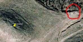
I just noticed a strange mound and pit in NW Mexico.

Is it possible - the earth used to make the mound on the right, was taken from the pit on the left?

Attached are two kml files, mound.kml, and pit.kml use Google Earth to view these files.

sitem.jpg

To the east of the mound looks like what could be an entrance to the mound. (obviously modern then) If it's modern, what in the heck is it?

sitem.jpg
 

Attachments

  • channel.jpg
    channel.jpg
    37.8 KB · Views: 1,499
  • mound.kml
    1.4 KB · Views: 159
  • Pit.kml
    1.4 KB · Views: 143
Nov 8, 2004
14,582
11,942
Alamos,Sonora,Mexico
Primary Interest:
All Treasure Hunting
HI Marc: Since I didn't have the coordinates, I downloaded it to my laptop then simply rotated the screen to the proper orientation, approx. 180* The yellow line is at the bottom.

It appears that there is a mesa with an outcroping on the Eastern end (top right). In the orig picture, it appears as a depression. There is a road that drops dwn to the flat land below where you do have another long out croping or a long roundish Mound. It is quite large.

There has been quite a bit of vehicle traffic in the area

On the second picture, the long object that is black in the center, could be a cattle watering trough. The black prob is water. There has been quite a bit of vehicular traffic to just this spot, which also tends to confirm the Trough idea.

The mound appearing (outcrop ) in the lower flatland, is interesting. Roads run to it.

Best that I can do for the moment Marc. The coordinates would help with Google

Jose
 

OP
OP
Marc

Marc

Silver Member
Mar 19, 2003
3,313
132
Northern Hemisphere
Primary Interest:
Cache Hunting
If you have Google Earth you can view the two "kml" files attached to the first post - however, here are the coordinates of the mound.

32 degrees 33'47.90" N 116 degrees 45'54.15" W

Elevation 627
 

OP
OP
Marc

Marc

Silver Member
Mar 19, 2003
3,313
132
Northern Hemisphere
Primary Interest:
Cache Hunting
jag1022 said:
Those KLM files point to a location in California not NM.

I just doubled checked the attached kml files, on a totally different computer - and they took me to the site as described.
 

Salvor6

Silver Member
Feb 5, 2005
3,755
2,169
Port Richey, Florida
Detector(s) used
Aquapulse, J.W. Fisher Proton 3, Pulse Star II, Detector Pro Headhunter, AK-47
Primary Interest:
Shipwrecks
Marc, thats one of the drug smuggling tunnels.
 

TheHarleyMan2

Bronze Member
Feb 27, 2008
1,594
464
Never Know I May Live Next To You!
Detector(s) used
GTI 2500/Bounty Hunter
Minelab Equinox 800
Primary Interest:
All Treasure Hunting
I think that if you look at the terrain around the mound, and look at the field where the mound is, it appears, that maybe the farmer had graded the land level to plant crops, whatever, and just piled the dirt into a mound. Also the patterns on the field indicates grade marks for farming.

A long time ago I knew a farmer that did that. He had a pretty good size chunk of land and really had no where to put the rocks, dirt, etc after he started grading it and just piled everything into a mound and smoothed it over to make a little hill.

Now the mound could have been dirt dug out of a tunnel for smuggling and they had used the plain for planting crops to disguise any activity going on there. Could be, but who knows unless someone is actually on the ground looking at it.
 

Top Member Reactions

Users who are viewing this thread

Top