In the Metairie Area

Chadeaux

Gold Member
Sep 13, 2011
5,512
6,408
Southeast Arkansas
Detector(s) used
Ace 250
Primary Interest:
Cache Hunting
I recently saw some maps from the Civil War which I'll try to post here. If they don't show up, you may want to go to the facebook https://www.facebook.com/groups/371484532958470/

10623625_10203906199912070_3449657575230920914_o.jpg


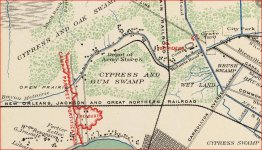
Metairie Road in the map from 1863 is the same today. Notice the Army Depot Stores which are south of where Bonnabel Blvd meets Metairie Road. Also visible is the location of Fort Redoubt

You can overlay the map in Google Earth for more accurate placement of the items.

I loved finding out that the Cemetery west of I-610 used to be a horse racing track ... which accounts for the odd layout of the roads there.
 

Attachments

  • 10623625_10203906199912070_3449657575230920914_o.jpg
    10623625_10203906199912070_3449657575230920914_o.jpg
    257.1 KB · Views: 1,158
OP
OP
Chadeaux

Chadeaux

Gold Member
Sep 13, 2011
5,512
6,408
Southeast Arkansas
Detector(s) used
Ace 250
Primary Interest:
Cache Hunting
Nice work Chadeaux

Thank you ... spent a lot of days in Marrero back when I drove a truck for Binswanger Glass out of Harahan, LA.

Do you guys still have the road where you have to share the pavement with the trains? Tracks ran down the middle of the pavement (at least I think it was Marrero).

If you do facebook, take a look at the group "Ain't Dere No More" ... every once in a while a jewel like that will pop up, as well as the "Old Metairie Memories" group. Some folks there that don't know what they're sharing sometimes.
 

OP
OP
Chadeaux

Chadeaux

Gold Member
Sep 13, 2011
5,512
6,408
Southeast Arkansas
Detector(s) used
Ace 250
Primary Interest:
Cache Hunting
Did a quick overlay to give you an idea ...

1863_NewOrleans_overlaid.jpg

Remember, this is an 1863 map. I made sure that the Pontchartrain Railroad (where the 17th street canal now lies) and Carollton Ave aligned properly and then resized until it was close.

Apparently the western ramparts to the city were about where Causeway Boulevard is today. and the fort just to the east.

I would wager that the road coming out of the fort and going to Metairie Road was most likely Labarre Road, again the inaccuracy of a 150 year old map would cause this.
 

Solatex

Greenie
Nov 18, 2012
11
5
From N'Awlins, La; Lived in Texas, back in La, jus
Detector(s) used
F5 and a POS Radio Shack
Primary Interest:
Metal Detecting
Hey Yall
I just moved back to Louisiana, after living in Guadelahouston for 20+ years. I lived most of my life in Metairie and saw the whole area grow up. Not sure how old you guys are but when I was a kid:
-Veterans Highway had only 2 lanes on one side of the canal
-Clearview was a shell road only between Airline and the lake
-Most everything between Veterans and the lake, west of Causeway was unbuilt.
-There were still old indian mounds at the end of Bonnabel close to the lake
-From Veterans to the lake,Williams Blvd in Kenner was woods and cow pasture
-No, I did not fight in the Civil war. This was in the 1960s

You may know about this already. If you drive north on Severn from west Metairie going towards Rummel, the road rises sharply. That is supposed to be a remnant, and the only one I now of, of the Confederate ramparts. If you go across Jefferson near Causeway, the old powder magazine from Camp Parapet is/was still there and fenced off. Not the nicest neighborhood in Jefferson Parish though so drive through there in the daytime

Like everywhere else, the area along the river was the highest land elevation. During the colonial days, most of what is Metaire was used for farmland to grow fruit & vegetables to support the city.
 

Last edited:
OP
OP
Chadeaux

Chadeaux

Gold Member
Sep 13, 2011
5,512
6,408
Southeast Arkansas
Detector(s) used
Ace 250
Primary Interest:
Cache Hunting
Hey Yall
I just moved back to Louisiana, after living in Guadelahouston for 20+ years. I lived most of my life in Metairie and saw the whole area grow up. Not sure how old you guys are but when I was a kid:
-Veterans Highway had only 2 lanes on one side of the canal
-Clearview was a shell road only between Airline and the lake
-Most everything between Veterans and the lake, west of Causeway was unbuilt.
-There were still old indian mounds at the end of Bonnabel close to the lake
-From Veterans to the lake,Williams Blvd in Kenner was woods and cow pasture
-No, I did not fight in the Civil war. This was in the 1960s

You may know about this already. If you drive north on Severn from west Metairie going towards Rummel, the road rises sharply. That is supposed to be a remnant, and the only one I now of, of the Confederate ramparts. If you go across Jefferson near Causeway, the old powder magazine from Camp Parapet is/was still there and fenced off. Not the nicest neighborhood in Jefferson Parish though so drive through there in the daytime

Like everywhere else, the area along the river was the highest land elevation. During the colonial days, most of what is Metaire was used for farmland to grow fruit & vegetables to support the city.

Sounds like we're about the same age. Went to Bridgeport elementary for a few weeks in 1964 then to Metairie Grammar for a couple of years before moving to La Place.

My mom's folks lived on Carolton Ave between where the interstate would be built and the railroad tracks by Metry (Metairie) Road.
 

Solatex

Greenie
Nov 18, 2012
11
5
From N'Awlins, La; Lived in Texas, back in La, jus
Detector(s) used
F5 and a POS Radio Shack
Primary Interest:
Metal Detecting
Sorry, have been out of town.

I know the area well. I grew up in Airline Park, got married, moved to Harney, moved back to Airline park, then moved to Houston. Retired in October and moved back , but near Natchitoches. Will be 62 in January.
 

OP
OP
Chadeaux

Chadeaux

Gold Member
Sep 13, 2011
5,512
6,408
Southeast Arkansas
Detector(s) used
Ace 250
Primary Interest:
Cache Hunting
Sorry, have been out of town.

I know the area well. I grew up in Airline Park, got married, moved to Harney, moved back to Airline park, then moved to Houston. Retired in October and moved back , but near Natchitoches. Will be 62 in January.

Well, welcome back. Hope all is well. Will be 59 this fall.
 

jharhed

Hero Member
Jan 5, 2008
780
133
Marrero LA
Detector(s) used
DFX, MX5, M6, Garrett Pro Pointer AT
Primary Interest:
All Treasure Hunting
Lookin at that map, I need to be hunting closer to city park ave, usually my "winter" spots, less people out
 

LMDAVE

Tenderfoot
Jul 30, 2015
7
2
Metairie, LA
Primary Interest:
All Treasure Hunting
You may know about this already. If you drive north on Severn from west Metairie going towards Rummel, the road rises sharply. That is supposed to be a remnant, and the only one I now of, of the Confederate ramparts.

I know this is an old thread, but I always wondered what that wall is in my neighborhood. I assume you are referring to this? So that is a civil war remnant?

413148249.jpg
 

Markdb353

Greenie
Sep 13, 2017
19
62
Metairie, La
Detector(s) used
AT Pro
Primary Interest:
All Treasure Hunting
LMDAVE - I live in Metairie myself and I believe I recognize this area as Severn, is this correct? Have you ever determined if this is part of the Civil War remnant?

A few weeks back, they were tearing up the soil where the old Piccadilly's was located which is inside the outlined area on the map overview above. Some of the soil was relocated to the canal banks on W.Napoleon as fill. A younger child and his father was metal detecting there so I pulled up to talk with them. While I was there, the kid hit a target and pulled out an old horse shoe. Pretty neat to see 1st hand, knowing that this came from the civil war area listed on this map.
 

Truth

Gold Member
Apr 13, 2016
14,332
32,142
Abita Springs La....Born in New Orleans
🥇 Banner finds
2
🏆 Honorable Mentions:
1
Detector(s) used
EQUINOX 800
Primary Interest:
Metal Detecting
LMDAVE - I live in Metairie myself and I believe I recognize this area as Severn, is this correct? Have you ever determined if this is part of the Civil War remnant?

A few weeks back, they were tearing up the soil where the old Piccadilly's was located which is inside the outlined area on the map overview above. Some of the soil was relocated to the canal banks on W.Napoleon as fill. A younger child and his father was metal detecting there so I pulled up to talk with them. While I was there, the kid hit a target and pulled out an old horse shoe. Pretty neat to see 1st hand, knowing that this came from the civil war area listed on this map.

Have you went and hunted there?
 

LMDAVE

Tenderfoot
Jul 30, 2015
7
2
Metairie, LA
Primary Interest:
All Treasure Hunting
LMDAVE - I live in Metairie myself and I believe I recognize this area as Severn, is this correct? Have you ever determined if this is part of the Civil War remnant?

A few weeks back, they were tearing up the soil where the old Piccadilly's was located which is inside the outlined area on the map overview above. Some of the soil was relocated to the canal banks on W.Napoleon as fill. A younger child and his father was metal detecting there so I pulled up to talk with them. While I was there, the kid hit a target and pulled out an old horse shoe. Pretty neat to see 1st hand, knowing that this came from the civil war area listed on this map.

Sorry just getting back to this. I never confirmed it, but it interesting what you wrote about the soil. I live in this area, and I was digging in my backyard a few years about near my shed to bury some electrical conduit and found this interesting stone. Could be nothing but had a weird appearance on it as if it could have been an Indian weapon/artifact. Even the tip of the spike had a weird coloration on the point of it as if it could have been dried blood. I never had it check out or anything. Just weird how it fit into a human hand, and there was even an indent where a thumb could rest on it to hold it better.

411532586.jpg


411532592.jpg


411559683.jpg


411532585.jpg
 

Top Member Reactions

Users who are viewing this thread

Top