Precision, accuracy, and handhelds

StogieJim

Jr. Member
Feb 26, 2007
88
5
Colorado Springs, CO
Detector(s) used
Exp 2, Tejon, & Compadre
Primary Interest:
All Treasure Hunting
Hi,

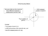
Thought I'd use GPS to help guide me to places to MD. Goggle earth displays location ddd mm ss.ss (note the two decimal places on the seconds). Talked to Magellan and Garmin about the precision of their products and all they know is the accuracy value. I had to explain the difference between precision and accuracy as it pertains to GPS.

Magellan only supports whole seconds (and minutes to 3 decimal places). Garmin presents tenths of seconds (ss.s). Perhaps I should have looked around more but, I settled for a Garmin etrex legend (100 bucks).

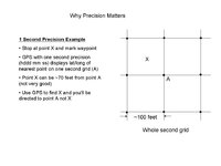
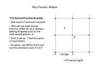
I put together three slides that explain why precision matters and how it's different from accuracy. Hope you find them interesting.

Jim
 

Attachments

  • Slide1.JPG
    Slide1.JPG
    45.7 KB · Views: 671
  • Slide2.JPG
    Slide2.JPG
    48 KB · Views: 652
  • Slide3.JPG
    Slide3.JPG
    45 KB · Views: 657

CWnut

Hero Member
May 9, 2003
591
37
E. Tennessee
Detector(s) used
Tesoro tigershark----Tesoro Conquistador Umax------Fisher FX-3----Master Hunter CX-Plus w/ depth multiplier
Primary Interest:
All Treasure Hunting
I have used an Etrex now for about 7 years. To be honest i abandoned all the degree/min./sec, degree/d.d and so forth and have used UTM coordinates for several years now. Your gps should go down to 1 meter precision, although your accuracy without WAAS will be about 15 meters. Go to gpsnow.com for a lot of info on using UTM coordinates. I think you will like them much better once you understand how they work. I use Terrain Navigator software to print maps and exchange routes, tracks and waypoints.
 

OP
OP
StogieJim

StogieJim

Jr. Member
Feb 26, 2007
88
5
Colorado Springs, CO
Detector(s) used
Exp 2, Tejon, & Compadre
Primary Interest:
All Treasure Hunting
Thanks CWnut, I'll look into that. I'm mentioning lat/long here because GoogleEarth gives lat/long. Perhaps they can give utm instead. My intention is to use various map/image sources in GoogleEarth (see note below) to identify the location of old structures and use the gps to guide me there. If GoogleEarth can't give utm, then I might have to use lat/lon, because transforming from lat/lon to utm is not trivial (there are several sites that do this conversion).

Note: I've just started importing maps into GE and perhaps you'd like to hear about it. For $20/yr, I upgraded to GEplus. It gives a few more features including importing image layers. I obtained a 1937 aerial photo and cropped out an image ~2k x 2k pixels which I took into GE. Now GE lets you rotate and resize your image to fit the surface; but, that's no substitute for a real georegistration. To get around this problem, keep the images brought into GE to a fairly modest area. That's why I cropped the 2k x 2k image from the original image rather than shrank the entire image down to 2k (a GE limiting size).

When the image is registered as well as you can get it, use the path drawing tool and point marker to highlight possible search areas and things of interest. Turn off the image layer you've imported and note the positions in the context of the current surface. Use the displayed lat/lon (hopefully utm) and the gps to guide you to the search area. Make sure your gps uses the same datum and ellipsoid as GE.

That's it in a nutshell, send me a pm for other details.

Jim
 

Red_desert

Gold Member
Feb 21, 2008
6,869
3,521
Midwest USA
Detector(s) used
Garrett Ace 250/GTA 1,000; Fisher Gold Bug-2; Gemini-3; Unique Design L-Rods
Primary Interest:
All Treasure Hunting
I was just checking on the Internet and Walmart website has the Garmin eTrex Vista HCx Handheld GPS on sale for $219.
 

Bum Luck

Silver Member
May 24, 2008
3,482
1,282
Wisconsin
Detector(s) used
Teknetics T2SE, GARRETT GTI 2500, Garrett Infinium
Primary Interest:
All Treasure Hunting
I like WGS 84. It is easily convertible into a lot of other formats with a wide variety of software and intuitively works well with compass directions, navigational charts and USGS topo maps.

I use dd mm ss.sss, but that's a personal preference since I am a land surveyor and that's how all my equipment works. My Leica GPS accuracy is sub-centimeter horizontally, and about centimeter vertically, but you'll spend a lot of money to get that.

For work I like to use our DOT-engineered county coordinate system, but there is no reason to be in those systems if you're not into precise measuring.
 

nascarfan

Full Member
Jul 17, 2005
235
2
Stogie, I know just enough to be dangerous with these GPS devices, however, I am using a Magellan Explorist 500 with amazing accuracy......A friend of mine gave me a program that converts Google Earth coordinates over to GPS coordinates and vise versa!! I did try attaching this file to my reply but it wouldn't let me do that, so, if you want, you can email me and I'll try attaching this file for you. It works great and again, I take no credit for making this program!!! Just PM me w/ your email address......... Thanks, Nascarfan ;D :thumbsup:
 

homestead-hunter

Full Member
Jan 18, 2013
185
83
Roswell, New Mexico
Detector(s) used
Garrett GTI 2500
BH Elite 2200
Primary Interest:
All Treasure Hunting
Google earth uses WGS84 as its datum. Your GPS should be have that. I use UTM, which is more accurate than other formats and easier to read, they break everything down into 1000 meter grids.
 

Top Member Reactions

Users who are viewing this thread

Top