Second broad river, NC

Jwoot

Jr. Member
Feb 24, 2013
63
12
Primary Interest:
All Treasure Hunting
How far does gold travel in streams? There is a history of mining on this river and its tributaries but south maybe 30 minutes of driving(below forest city NC) I see no history of mining. Does anybody have any experience with this? Would gold not have traveled this far? Or maybe it was never found to be economical? Upstream the river contains good gold and many of its creeks contain good gold.


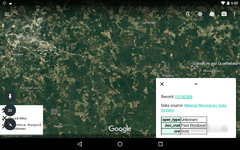
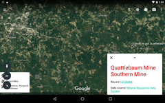
All the mines from the map run into This river the second broad river. It runs by the area called cliffside in the map. Is there any reason there wouldn't be gold in this area?
IMG_0081.PNG
 

Upvote 0

enamel7

Gold Member
Apr 16, 2005
6,383
2,546
North Carolina
Detector(s) used
Garrett AT Gold
Primary Interest:
All Treasure Hunting
It will be there. Gold will travel as far as it can. That's why there is gold on the beach somewhere near Wilmington.
 

KevinInColorado

Gold Member
Jan 9, 2012
7,037
11,370
Summit County, Colorado
Detector(s) used
Grizzly Goldtrap Explorer & Motherlode, Gold Cube with trommel or Banker on top, Angus Mackirk Expedition, Gold-n-Sand Xtream Hand pump
Primary Interest:
Prospecting
No mining shown on your map because that's probably based on USGS data which is focused on commercially viable/actual deposits.
 

Delbert h.

Tenderfoot
Apr 30, 2017
5
2
York sc
Primary Interest:
Other
Not sure, but they say there's gold in the broad river in York SC. I know the tributaries contain some.
 

chlsbrns

Bronze Member
Mar 30, 2013
1,636
656
Detector(s) used
Excalibur II
Primary Interest:
Other
USGS Data is NOT focused on commercially viable deposits. The USGS samples stream sediments, soils, rock, concentrates and others. USGS reports show the results of numerous minerals including gold. A report will show in parts per million or parts per billion of each element.

This report shows 10ppm gold found at the specified location.
https://mrdata.usgs.gov/pluto/sediment/show.php?place=f45091

Other reports of other locations show fractions of one ppm or no gold found.

In other words the USGS reports will show whatever amount of each mineral was found in each sample. From none to very large deposits.

The USGS also has numerous specific reports on gold such as the report below that is specific to gold. It shows numerous locations with visible gold including locations in the Broad River.

https://www.google.com/url?sa=t&sou...IrBmP29L005KxCtFg&sig2=KfeNnF1-3TZNGXLzBTRhfw
 

Last edited:

KevinInColorado

Gold Member
Jan 9, 2012
7,037
11,370
Summit County, Colorado
Detector(s) used
Grizzly Goldtrap Explorer & Motherlode, Gold Cube with trommel or Banker on top, Angus Mackirk Expedition, Gold-n-Sand Xtream Hand pump
Primary Interest:
Prospecting
Um ok. Not sure how their (valuable) reports are relevant to the mine site data they provide which is used by these mapping tools. But ok.
 

Clay Diggins

Silver Member
Nov 14, 2010
4,912
14,326
The Great Southwest
Primary Interest:
Prospecting
The Original poster's map shows the general locations of some mines. This MRDS (Mineral Resources Data System) information is from the USGS and focused on commercially viable/actual deposits. The MRDS shows actual mines and workings and contains some data on actual observations of the workings. I think the original poster already knows that since they referred to the history of mining and the actual mines displayed on their map.

The USGS MRDS does not have geochemistry or mineral potential but other programs (NURE, PLUTO, NGCDB and several other specialized programs) do have some of those features. There are many geologic databases as well as mineral potential and geologic maps of particular areas available from the USGS. None of that is the subject of the original posters question.

To answer the original posters question... Gold travels as far downstream as it can before being trapped in a riffle, clay body or low pressure zone. Generally gold is the last mineral to move and the one least susceptible to being broken down into smaller pieces. That makes gold pretty darn slow moving. Gold of any quantity will almost always be found near it's source.

Gold does not usually form "nuggets". Most gold is deposited and eroded from the rock in small particles. The size and shape of the gold particle have as much to do with how far it travels as does the incidence of flood or landslide.

So the answer is "it depends but not very far". The idea that all gold eventually travels to the sea is only true over time spans much greater than humans have been on earth. You could set up at the mouth of any river and wait for the gold to arrive but if you were to sample most current river's mouths you will find out rather quickly that is not a productive way to prospect.

Gold is where you find it but assuming gold will always travel further downstream is not an assumption that will pay off in any quantity of actual gold. Try panning the mud of San Francisco Bay where all the Motherlode rivers drain to and you won't find gold worth panning.

Heavy Pans
 

Last edited:

chlsbrns

Bronze Member
Mar 30, 2013
1,636
656
Detector(s) used
Excalibur II
Primary Interest:
Other
This MRDS (Mineral Resources Data System) information is from the USGS and IS NOT focused solely on commercially viable/actual deposits.

You can see by the attached screenshots that the USGS MINE DATA also shows prospects and occurances along with mines many of which are small, insignificant mines.

https://mrdata.usgs.gov/mrds/show-mrds.php?dep_id=10100388
 

Attachments

  • Screenshot_20170503-180006.png
    Screenshot_20170503-180006.png
    1,000.4 KB · Views: 202
  • Screenshot_20170503-175952.png
    Screenshot_20170503-175952.png
    1 MB · Views: 150

Top Member Reactions

Users who are viewing this thread

Top