Texas Brigade Camp by Clinton, MS

Missboy

Jr. Member
May 30, 2008
26
3
Clinton, Mississippi
Detector(s) used
Shadow/Whites/DetectorPro/Mark II
Missboy said:
Anyone have knowledge of a Teaxs brigade camping on the west side of Clinton during civil war? I remember reading that they had camped about 3 miles west of town but not sure of how to figure out where west (NW, SW or due W) or 3 miles is from 'town", any suggestions would be helpful.

Thanks,
Joe (Missboy)
Clinton

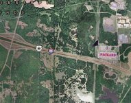
Joe I think it is just past the Packard Electric Plants
 

it was at whites plantation it was located where packard elet, now sits under asphalt sorry
 

:'(

Thats what I was afraid of,,,may need more than a jackhammer to try to find stuff around there. Will keep that in mind though if I ever see any dirt getting moved around there in the future. Appreciate the info!

Joe
 

HeyTreasurebum,

what do you know about Boscobel plantation, any of the area possibly open for hunting if the landowners can be found?
 

The unit had to march into that area, they didn't just plop down there. Check along the Clinton-Raymond Road and the Clinton-Vicksburg Road for creek crossings where picket camps could have been setup.
 

3 miles from old downtown Clinton would actually be a little bit past Packard Electric (see photo below). & I'm sure they camped by a pond or stream.
 

Attachments

  • Packard1.jpg
    Packard1.jpg
    118 KB · Views: 478
In the CW times, distances were usually measured post office to post office or railroad depot to depot, along any rail lines. If you can locate the rail depot as it was in the 1860s and the post office in that time period use a drawing compass to strike a circle around the two points with the distance set as the radii of the circles. If you're looking for a point actually ON the rail line at an "X" distance, then measure from the RR depot.

Make sure the roads are the PROPER roadways. For instance, in Jackson, Raymond Road running from South Terry Road, westerly is the original Jackson to Raymond Road; South Robinson Road is NOT. Clinton Boulevard running out of Jackson, to Clinton is the original Jackson to Clinton Road. Terry Road is the original Jackson to Terry Road (duh). It is also the original route of the US 51 Highway that runs north and south through Jackson. It was the only highway, running north and south before I-55 was built in 1966. For the original roads running east and west out of Jackson toward Vicksburg, FORGET I-20 and U.S. 80. There are very few places where U.S. 80 follows the original route. Too few to worry about and I-20 can be completely ignored. There were 2 routes running from Jackson to Vicksburg; one north and the other south of both I-20 AND U.S. 80.

If you live locally, go to the Mississippi State Archives, just off of State Street and join. Then make full use of the information there. They have copies of most old Mississippi newspapers, city and county maps, private diaries, etc. There's no membership fees for Mississippi residents, but there are costs for photocopies of material. They have the capability to photocopy the larger items such as maps, too. The charges for coping are reasonable, but call before you go there the first time, to find out how the payments can be made. It might save you a fair amount of time in your research on your first trip. It's become natural after the first trip. :thumbsup:
 

Top Member Reactions

Users who are viewing this thread

Back
Top