EnvoyToTheMolePeople
Sr. Member
- Joined
- Oct 1, 2018
- Messages
- 435
- Reaction score
- 675
- Golden Thread
- 0
- Location
- Western PA, Northern NJ
- Detector(s) used
- Garrett AT Max
- Primary Interest:
- All Treasure Hunting
So, about a year ago I was exploring a wooded area with a friend and he pointed out this granite boulder on top of a hill (most of the rock in the area is sandstone). I went over to take a closer look and noticed some words carved into the stone. Since then I've done as much research as possible and come up with almost nothing of use, so maybe there is an off chance that somebody here could give a little insight.
Here's what I know:
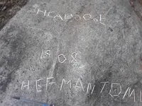
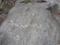
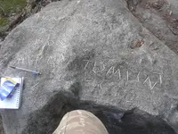
The carvings are nearly impossible to take pictures of, so I broke some toothpicks and placed them into the carvings as best as I can read them.


It appears to read
HCADoOoE
1908
HEFMAN TOMLIN
I doubt the oOo is actually that, but it is difficult to say what it really is
The C is also a little iffy, the F may be a P, the O in TOMLIN has a dot in it
Hefman/Hepman and Tomlin don't could be last names but the property boundaries indicate that nobody really owns (or has owned) that land. I couldn't find any reference to either name in local records, so they could mean something else. The dot in the O is very well defined, but I don't know what it means.
TOMLIN could be Town Of Montclair LINe, but the dot in the O and the distance of the rock from the border make that somewhat unlikely.
The boulder is large and firmly planted in the ground, I doubt it has ever been moved by human hands.
I'm pretty sure the boulder is granite, but feel free to correct me.
That's the sum of information I have about the stone, next is for the surrounding area.
This is the approximate location of the stone: 40.803385, -74.208553
It is in Glen Ridge, NJ.
The hill is called Indian Hill or Indian Mound. Assuming it is actually of Native American origins, the hill's description matches that of others nearby that were used "to store food for winter". I don't really know what that means or how that would work, but I doubt the food would be stored inside the hill because the local population didn't have much construction capability.
This Sanborn map shows an unknown structure just south of, and across the railroad from, the Capillaris mfg co. It shows up only as a line, but I know it must be something man made, because an old dam further down stream shows up as a similar line.
https://maps.princeton.edu/catalog/princeton-cr56n295b
The hill is down a ravine with one side bounded by a stream and the other by railroad tracks.
The area was heavily wooded until the 1940s and home to a small amount of minor criminal activity (specifically, an illegal craps game) and the occasional brush fire, aside from that there was very little action in that spot. The closest industry was a mill a few hundred feet downstream and across some RR tracks. The closest houses are up 50 ft cliffs.
Well, that's a year's worth of research condensed into one post. Let me know what your thoughts are, nobody I know has been much help. It's possible that I'm the first person to care about this in 100 years.
Here's what I know:
The carvings are nearly impossible to take pictures of, so I broke some toothpicks and placed them into the carvings as best as I can read them.


It appears to read
HCADoOoE
1908
HEFMAN TOMLIN
I doubt the oOo is actually that, but it is difficult to say what it really is
The C is also a little iffy, the F may be a P, the O in TOMLIN has a dot in it
Hefman/Hepman and Tomlin don't could be last names but the property boundaries indicate that nobody really owns (or has owned) that land. I couldn't find any reference to either name in local records, so they could mean something else. The dot in the O is very well defined, but I don't know what it means.
TOMLIN could be Town Of Montclair LINe, but the dot in the O and the distance of the rock from the border make that somewhat unlikely.
The boulder is large and firmly planted in the ground, I doubt it has ever been moved by human hands.
I'm pretty sure the boulder is granite, but feel free to correct me.
That's the sum of information I have about the stone, next is for the surrounding area.
This is the approximate location of the stone: 40.803385, -74.208553
It is in Glen Ridge, NJ.
The hill is called Indian Hill or Indian Mound. Assuming it is actually of Native American origins, the hill's description matches that of others nearby that were used "to store food for winter". I don't really know what that means or how that would work, but I doubt the food would be stored inside the hill because the local population didn't have much construction capability.
This Sanborn map shows an unknown structure just south of, and across the railroad from, the Capillaris mfg co. It shows up only as a line, but I know it must be something man made, because an old dam further down stream shows up as a similar line.
https://maps.princeton.edu/catalog/princeton-cr56n295b
The hill is down a ravine with one side bounded by a stream and the other by railroad tracks.
The area was heavily wooded until the 1940s and home to a small amount of minor criminal activity (specifically, an illegal craps game) and the occasional brush fire, aside from that there was very little action in that spot. The closest industry was a mill a few hundred feet downstream and across some RR tracks. The closest houses are up 50 ft cliffs.
Well, that's a year's worth of research condensed into one post. Let me know what your thoughts are, nobody I know has been much help. It's possible that I'm the first person to care about this in 100 years.


![IMG_20180612_210228[1].webp IMG_20180612_210228[1].webp](https://www.treasurenet.com/data/attachments/1553/1553988-6af06c2b5b1251eb29f99a57281c0a6f.jpg?hash=uTQrqUbavC)
