Am I seeing things here...

GioTheGreek

Bronze Member
Joined
Sep 12, 2009
Messages
1,281
Reaction score
859
Golden Thread
0
Location
Hades
Detector(s) used
XP DÉUS, Minelab E-TRAC, Pro-Pointer, Hawk-like Vision, Receding Hairline
Primary Interest:
Metal Detecting
For those experienced in finding sites with the help from google and bing maps...

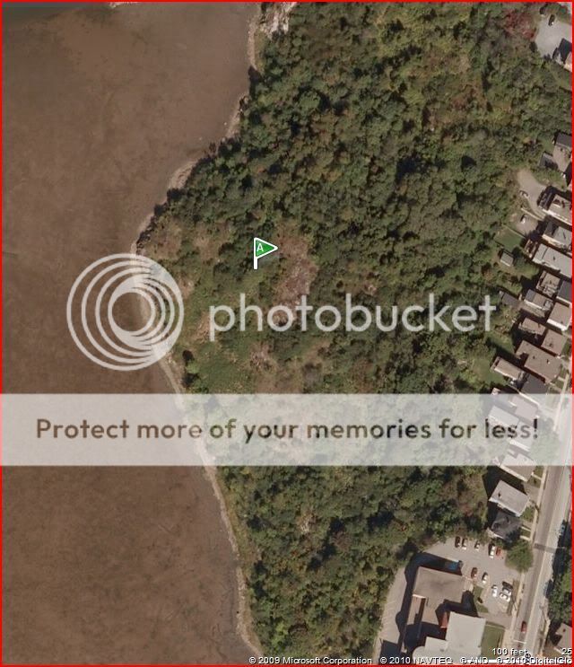
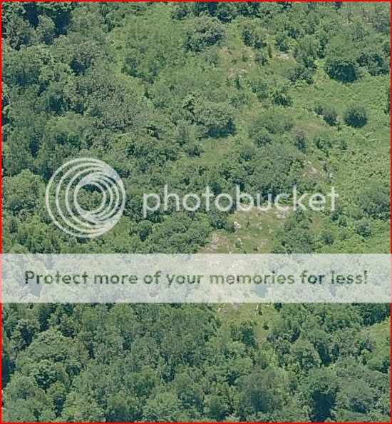
Do you see any remains here? Is this just a natural occurrence or did a house possibly stand here?

Thanks for your help.

mcove12.jpg


mcove11.jpg
 

Paths through those trees? How old are the trees, or type? A further zoom out might help. Those right angles don't seem all that natural to me.
 

Your pictures appear more like aerial photo's not sat photo's. Too bad you won't disclose the gps coordinates. I would have liked examining the surrounding terrain and obvious human activity, ie..roads built, etc. Your first picture at top displays a right angle. That is man-made not nature. Many sites that look like that have turned out to be very old cemeteries...that explains why the land has been cleared and somewhat maintained. Look at my posting of Northern Florida Forts here.... Ft. Buckeye is very much like your site...that cemetery dates back to 1808. Yours just seems to be more remote.

goldcoastwayne
 

I believe I see two areas of roads or trails. It would really help if you could pull back and show more. Off the cuff, that there is no regrowth seems odd, unless it was recently cleared. It's relative utter barreness does bother me. Pulling back may show areas of newer growth and older growth which could tell us more. It is okay to be paranoid, but if you are overly paranoid you won't find much in the way of direct assistance on a message board--especially one as big as this one is.
 

Haha no worries lads.
 

Only reason I ask is that I've looked at a few maps, different eras, and never saw any homes in that specific area. It does look like something was there... unless its just a lucky bedrock formation lol.

It's on someone's land so... no permission, no play.
 

I know there was activity in the area in the past. People used to go skating on the cove in winter... but not much action aside from that. A good drinking spot for bums and teens. lol
 

GioTheGreek said:
I know there was activity in the area in the past. People used to go skating on the cove in winter... but not much action aside from that. A good drinking spot for bums and teens. lol

Can somebody post a a couple of zoom outs?
 

Here's a zoomout Belle.

Sorry was working earlier. :)

mc.jpg
 

PM me a link if possible/if you want. Certainly not far from civilization.

Thanks for sharing!
 

If I plugged in your posted coordinates correctly, the picture of the houses is not the site. The terrain with the houses doesn't even come close to your original pictures..lol?? I have your site in New Brunswick, Nova Scotia (according to your coordinates). It is not far from Lepreau Falls. I need not tell you, that if this is correct, there is much history in your locale (that is a Canadian flag you are displaying, right lad?). I would first look at: http://en.wikipedia.org/wiki/New_Brunswick

If you want to know more about the history in that area (both French and British) follow my general steps that I have laid out in "Forts of North Florida". Your locale is full of history and you may be on something that is much more than a "place where skaters and bums hang out". If you actually want to pursue your study further you can contact me for costs involved with research. Below are the Satellite photos of the coordinates that you posted:

goldcoastwayne
 

Attachments

  • image..unknown.webp
    image..unknown.webp
    107.2 KB · Views: 1,697
  • image..unknown2.webp
    image..unknown2.webp
    79.4 KB · Views: 1,692
  • unknown...3.webp
    unknown...3.webp
    95.1 KB · Views: 1,669
Depends on what service he used and what year his image was taken. A fort near the water makes sense in theory. Without zoom in-out and inability to tilt I'm outa here. I'm currently working for free elsewhere. :laughing9:
 

BloodyBelle said:
Depends on what service he used and what year his image was taken. A fort near the water makes sense in theory. Without zoom in-out and inability to tilt I'm outa here. I'm currently working for free elsewhere. :laughing9:

The date of my satellite images are April, 2007. It is Google Earth. There is no body of water near them (by at least several miles)...yet alone houses...lol. Good luck with your search..I don't have time for stupid stuff or the author playing games. It is quite interesting how the author removed the coordinates after he posted them at my request...the coordinates are still marked on my sat photos above. I suggest that you think twice about posting coordinates publicly if you want these to remain private..also, don't waste other people's time asking for help if you are playing games. Take care "lad".

goldcoastwayne
 

Top Member Reactions

Users who are viewing this thread

Back
Top Bottom