Any ideas what this could be

NSD4581

Tenderfoot
Joined
May 4, 2024
Messages
4
Reaction score
2
Golden Thread
0
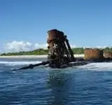
Hi everyone, this is my first post on this forum. I was messing around on Google earth and found this. I know it’s a shipwreck, but don’t know what type, or anything else. I’ll link the coordinates here: 4.66092° S, 174.54511° W
If you have any ideas, please let me know!
 

Hi NSD4581,
Welcome to the "Show"!
I believe you show the co-ordinates for the "SS Norwich City" 4°39'39.3"S 174°32'42.4"W which sunk in 1929.
 

Attachments

  • Shipwreck.webp
    Shipwreck.webp
    4.1 KB · Views: 46
Thank you so much. I found one more in the same island of Noriti! 4.65440° S, 174.53962° W. It looks to be a smaller wreck, so maybe a plane or tank?
 

Top Member Reactions

Users who are viewing this thread

Back
Top Bottom