desertmoons said:
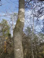
I do mean that skinny tree. Do you notice how the main tree and the skinny tree mimic each other in shape? If those branches are high up, those that have been stripped off, perhaps someone did it on purpose.
For example , to make sure the spring was marked now..and long into the future. If so it denotes a long view of things which is interesting. Have you a native population there?
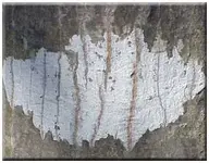
The first photo has some questions on it the second photo is just a really cool tree!
As far as the history:
From what I can figure out the Caddo Indians were in the area, I am in Franklin County, Texas. Here is some history of this area:
Franklin County has a long and narrow north-south configuration. The Cherokee Trace runs along our eastern boundary; a Caddo Indian highway which led from the southern regions of the Caddo Confederacy near Nacogdoches into Oklahoma. Accounts by French traders and travelers in the 1700's report that the highway was wide enough for four horsemen to ride abreast through the thick forest.
Nicholas Trammel traveled this route in 1812 and it is also called Trammel=s Trace. Settlers adapted the road for their own uses. Only a few remnants remain open in the east half of the county.
The Cherokee Indians traveled this highway in the 1820's and 1830's when they were expelled from their native lands in the eastern states. One band of Cherokees settled near Nacogdoches. With Mirabeau B. Lamar's 1839 election as president of the Republic of Texas, they traveled the same route north when the Republic expelled them to Oklahoma. We call this the Cherokee Trace and it is truly a part of the Trail of Tears.
The Choctaw Trail, an East-West Indian Trade Route passes through the county parallel to present U.S. Highway 67. The last Indian Massacre in the eastern half of Texas was on April 10, 1841, just east of Mt. Vernon on the Cherokee Trace.
The Choctaw trail passes through Mt. Vernon as Main Street. West of Mt. Vernon, the trail was known as the Mt. Vernon to Sulphur Springs Road and was incorporated as a part of the Bankhead Highway Route in 1919. The Bankhead Route turned down Holbrook Street and followed the Old Jefferson Road into Mt. Pleasant (north service road of I-30). In the 1930's, the Choctaw Route was abandoned and present US Hwy 67 was opened to the south between Saltillo and Winfield. In the 1930's, this route was first designated as US #1. The Route was also called "The Broadway of America"; this name remained on the Optic-Herald Masthead until 1964 when I-30 opened south of the US 67 route.
Kaufman Street in Mt. Vernon was known in the 1880s as the Mt. Vernon to Winnsboro Road, long before present day Hwy 37 was opened to Winnsboro. And Holbrook Street in the 1880s was known as the Mt. Vernon to Pittsburg Road.
There is speculation that the remnants of the LaSalle party passed through here as they tried to reach French Canada in the late 1600s. Spanish explorers of the 1500s probably came within present day Franklin County, given the meandering Indian trade routes that would have made travel easier for them. The De Soto expedition and later the Moscoso expedition may well have passed through here, and would have been relatively close in any event.


")