99thpercentile
Full Member
- Joined
- Nov 2, 2006
- Messages
- 165
- Reaction score
- 129
- Golden Thread
- 0
- Location
- Evergreen, CO
- Detector(s) used
- Geonics EM61-MK2, Geophex GEM-3, GapEOD UltraTEM III, Minelabs F3, Foerster MINEX 2FD 4.500
- Primary Interest:
- All Treasure Hunting
- #1
Thread Owner
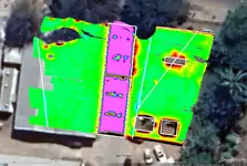
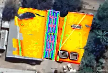
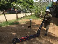
Here are some example images from data that I collected a few years ago in Guadalcanal while looking for POW/MIA remains. These figures were collected with a Geonics EM38-MK2 frequency domain electromagnetic induction (FDEM) instrument operated on a two wheel push cart that I designed and built. The EM38-MK2 measures the electrical conductivity and inphase (IP) response the ground at two depths, approximately 0.75 m and 1.5. The IP data functions mostly like a metal detector while the conductivity data can detect non-metallic targets as well. The data was logged on a Trimble Geo7x GNSS receiver that was also functioning as my positioning system. I connected the logger to the cellular data network and received GNSS corrections from the Australian GNSS continuously operating reference system (CORS). What that means is that I had positional accuracies of 1-2 cm when I had a clear view of the sky. My line spacing was approximately 0.5 m for these surveys and the data was collected at approximately 10 cm inline spacing.
FDEM instruments like this are used daily all over the world. The EM38-MK2 is one of the newest units in this series (EM38) of instruments and is primarily used for agriculture. They are often towed across fields several times per year when nothing is planted to help understand where to apply water and fertilizer the next season. The EM31 instrument is 4 m long and can measure down to approximately 6 m. The EM34 instrument has adjustable spacings of 10, 20, and 40 m that give depths of investigation of approximately 15, 30, and 60 m. The instruments can also be rotated 90 degrees to cut the depth of investigation in half. There are a handful of other companies in the world in addition to Geonics that make similar instruments.
The really strong response in the middle of the figure is the reinforced concrete driveway. Some of the rectangular features are fences and the linear features are pipes, many of which are non-metallic.