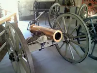
Regarding Fremont's Mountain Howitzer. The story I have on that is they abandoned the gun in the neighborhood of Sonora Pass, due to the steep climb and deep snow. It was supposedly found in the 1880's (From the book, History of Nevada 1886) and was displayed on a guys porch in Carson City. Sonora Pass is now the US Marine Corps mountain training area. I'm inclined to believe the barrel was found and packed off, there is a lost cannon mountain and a lost cannon creek just north of Sonora Pass, and Walker River is also north, but it's been a long time and I'm hazy on locations down there. There might very well be ammunition and it looks like those guys found iron carriage parts. The road over Sonora pass is a real booger, took my wife over, and she threatened to assume the fetal position
on the floor until we were over the top. Don't know about the bulge in the barrel, but I've been close to where they camped. My intention was to try and find the friction primer from
that shot. There is a road out to it, but at the last 1/4 mile or so, there is a closed gate. It's located on private property on the Klamath Marsh, I didn't have permission to go out
there, and on top of that, the Feds have a Wildlife Preserve on the marsh, and their headquarters are directly across from the point where the camp was. In that marsh area there are
signs, in fact a lot of signs that say, "NO ARTIFACT COLLECTING," along with the penalties if you even pick up an arrowhead or any rock. Typically, I didn't have a lot of time, I was heading
to hunt elk quite a distance away, so did the right thing, and obeyed the law, and only took pictures. They still call it the Klamath Marsh, but a lot of it has been drained and turned into
pasture. However the wildlife preserve is still marsh, and where the paved road crosses the marsh is still there. Where Fremont camped the marsh has been drained.
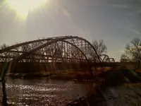
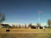
This picture is looking west. I'm in the marsh where Fremont probably crossed, it's very narrow right here. The pointed peak is Mt. Thielsen, and Mt. Mazama (Crater Lake) is to the left out of the
picture. I'm taking the picture standing in the Military Road. The Indian wars in central and eastern Oregon were the best kept secret until the Atom Bomb. The government wanted
people to move to Oregon, and the Indians didn't want them, so there were battles and forts, and the military road across the marsh.

There is a road that turns off the military road just behind that farm house, and I drove out to the point. I was driving in Lodge Pole Pines, and there is a fence along the marsh pasture,
so I'm assuming the Lodge Poles are BLM land. Like I said, I drove all the way to the point, only to find a gate, and I was able to look across and see the Wildlife Preserve headquarters,
and after reading all those signs my heart really sank. The arrow points to where Fremont camped in 1844. The reason for the cannon shot. In 1828 Jed Smith and 19 trappers were
driving a herd of horses purchased in California up the Oregon coast. Camped at the mouth of the Umpqua River, all but 4 of his men were killed, and he lost all his horses to the Umpqua
Indians, or as one of his men had phonetically spelled the name, Oomp Quak, and the distance over the mountains to the coast was unknown, so they were worried to begin with, and
supposedly the Indians that lived out in/on the Marsh on houses built on stilts, were acting menacing. So the only time the gun was fired was at that time. He fired an explosive shell timed
to blow up over the marsh, everything went quiet, then the next morning the Indians visited camp to see what kind of gun he had that would shoot twice. This information I've gleaned
from some pretty good primary source material.

And the next picture is a telephoto showing the point where they camped. The pasture is drained marsh land. Their camp was on the second or furthest point. The picture is looking
north, northwest.