GPS on CTX 3030

Geobound

Hero Member
Joined
Feb 21, 2017
Messages
614
Reaction score
867
Golden Thread
0
Location
Ontario
Detector(s) used
XP Deus (2019)
Fisher CZ-21 (2019)
CTX 3030 (April 2017)
AT Pro
Garrett Carrot
Pro Pointer
Stavr Scoop Moonstrik 6
Stealth 720i (BNIB)
Home made beach scoop
Primary Interest:
All Treasure Hunting
How many of you CTX 3030 users actually use the GPS function?

I don't mean the first few times you went out and wanted to try it, but actually use it and upload the data to the web to look at later?

I theory the GPS seems like a good idea, but the more I think about it the more I think it's a waste of money.

Too bad there isn't a way to get a CTX 3030 with and without GPS to save a few bucks.

I'm currently using an AT Pro, but will be moving to the 3030 in April so that's why the question came up.
 

I use it every single hunt and LOVE it. But I am anal about data retention and later use. Also use it to peg a spot I want to hike to, look for finds trends, mark property boundaries so I dont accidentally stray off the permission, look back during the hunt (now where did I pick up that silver coin?), sometimes even helps me to stay on grid. And I'm probably not using it in a dozen other ways I haven't thought of yet.

But if it doesn't work for you, that's all that matters. That's what wonderful about a free market; we all get to pick and choose the detector that is best for us as individuals.

eta: the ATP is a great machine as im sure you know. just a friendly warning that the CTX is going to drive you crazy coming from an ATP if you haven't ever hunted a FBS machine. STAY WITH IT and you'll be glad you did (if you don't go crazy from information overload).
 

Last edited:
100% agree on some liking the GPS and some not.

Perhaps once I get at 3030 in my hands and start to play with it, I will consider using it?

I've heard that it's a huge learning curve going from the AT Pro to the 3030, but I'm in this hobby for the long haul so I'm ready for a challenge........I hope?? LOL.....

Looking around I've seen people talking about different programs to download to get you started, but I will worry about that when the time comes.

I likely won't be picking one up until April, so I have a few more weeks to read up on them.

Thanks for the info.
 

I wouldn't get at all worked up over others' programs. Stock will do you just fine until you have some confidence in your CTX and by then you'll know what tweaks you need to make in your area, not someone else's. Truly, theres no 'best' program. Its all hype and hero-worship imo.

You're gonna love it. But keep the ATP as a backup or loaner.
 

I don't use it.
I also think they could offer a version with out it and pass the savings on to the customer.
And as far as programs there isn't to much to adjust compared to a Whites V3I,xlt type software. SO don't fall for the program hype adjust it to your needs.
 

Last edited:
If you are a yard or curbstrip hunter, it won't do you any good. If you hunt areas like beaches or farm fields, it can be great to show you what has been searched and where to start up next time. It can also show you find hot spots you won't notice otherwise, plus it can take you right back to that hot spot instead of guessing where it was last week/month/year etc.

Lastly, you can upload waypoints from your computer into the CTX, so if you have found map overlays of camp sights, homes, dumps, etc you can use the CTX to walk you right to the spot.


Okay now that part I can see as a bit of a bonus. I actually know of a really old site that I can get both an old map and a new map of. Hmmmmmm, interesting!
 

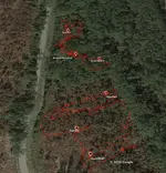
I've used mine from the start. I now convert and use google earth, more refined. pics of each find point is a nice too. I really use it cause it's there


HH
 

Attachments

  • Screen Shot 2017-03-08 at 10.43.41 PM.webp
    Screen Shot 2017-03-08 at 10.43.41 PM.webp
    115.2 KB · Views: 114
I've used mine from the start. I now convert and use google earth, more refined. pics of each find point is a nice too. I really use it cause it's there


HH


Okay, now that's just cool! LOL.....
 

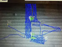
Here is a pic that shows about 6 different hunts , it's very helpful in searching the complete area.
I don't record find points , I just take a pic of the day's hunt and save the track and finds pic in
XChange 2
there's close to 500 finds dug in all this walking around shown in the pic
Actually the empty looking square in the lower right was searched like the other areas but I lost it trying to copy it into exchange.
BT
 

Attachments

  • IMG_2087.webp
    IMG_2087.webp
    2.1 MB · Views: 82
Capture.webp

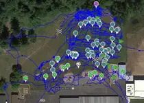
I use it to grid a location and track finds as well as coverage, here is a sample of a school yard clad finds marked in green IHP and Silver Dime marked in Pink.
 

Love this tech stuff. Wish it wasn't so expensive for just GPS =( Need a phone app that does the same thing lol, any suggestions?
 

I havent used mine yet. Wondering if it would in some way take xtra battery juice and maybe lessen depth....just one of my wacky thoughts....i do think you can use google earth history images (using the time bar at top) and put cursor on a spot you may be interested in hunting, look at coordinates in bottom right-hand corner and put them in the CTX to put you on the spot. I need to investigate this idea further.

GL HH


Using the GPS has zero impact on depth of detection. It may have a small impact on battery life, but the rechargeable last long enough that it's never been a problem for me. I have forgotten I left GPS on and weeks later never noticed a my batteries draining faster. Not saying it doesn't but it wasn't noticeable from ordinary use.
 

Good to know!! Now what do you think about the Google Earth suggestion?
 

Good to know!! Now what do you think about the Google Earth suggestion?

It will be easier to do through the xchange program is you can run it. Find the spot in GE, go into xchange and plot that coord. It will pull up on the GE/xchange map. make sure its the same spot. Save as a waypoint in xchange then transfer it to the CXT.
 

Sounds great !! Thanks !!
 

Great idea about using Google Earth in conjunction with your 3030.

I still don't know how often I would purposely use it, but I get why some do.

I'd like to see an option to get this machine with and without the GPS for cost savings and battery saver, but know it likely won't happen.
 

Great idea about using Google Earth in conjunction with your 3030.

I still don't know how often I would purposely use it, but I get why some do.

I'd like to see an option to get this machine with and without the GPS for cost savings and battery saver, but know it likely won't happen.


Yes, i think google earth's image bar that can be displayed and adjusted to see things that have changed over the years could be a very good tool. Everyone needs to download the latest version and get to enjoying that feature.

GL HH
 

Last edited:
I'd like to see an option to get this machine with and without the GPS for cost savings and battery saver, but know it likely won't happen.

Wont happen. The assembly line is already set up to build the current design. They would have to spend money to change the operation to leave the receiver chip off, which would cost money, so it wouldn't save the end buyer anything.
 

Top Member Reactions

Users who are viewing this thread

Latest Discussions

Back
Top Bottom