Green Cabin wreck Location

Yaco787

Tenderfoot
Joined
Oct 6, 2018
Messages
9
Reaction score
9
Golden Thread
0
Primary Interest:
All Treasure Hunting
Hey Guys, how are you?

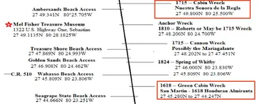
I was wondering if anyone had a "definitive" location/GPS for the Green cabin wreck on treasure coast.

I've looked at various books and maps but they all seem to have different locations that vary by more than a quarter mile. I know where the "scraggly tree is" which is where bob weller said the center of the wreck is, but then in the actual book it says that the wreck center is about 1000 feet south of Vero beach disney resort. The scraggly tree is MUCH further than 1000 ft south.

Also, i was wondering if there was any news on which ship the coins came from that were found directly behind disney in about 6 feet of water a few years ago.

They are 1715 coins, but there is no 1715 ship within a halfmile or more of that location. As i remember, they had 9 royales found which means that the coins came from a ship carrying treasure specifically for the king himself. Could there be another wreck undiscovered in that area?

Thanks
 

Coins came off of Corrigans site. And green cabin wreck is a good distance from there.
 

A very good resource if you are new-ish to the Treasure Coast can be found here:
http://www.mdhtalk.org/articles/beaches/1715-fleet/1715-article.pdf

Salvaging hurricane wreckage on a windward shore never a matter of "the ship and her cargo ar located at "## ##.### Lat, ## ##.### Long. in 57 feet of water" It is a scatter...you might find a ballast pile offshore in 40 feet of water, but the wreckage 'scatters' all to hell and gone. The scatter patterns on the 1715 Fleet wrecks are indicative of the ships being blown into too-shallow water, being gutted on the limestone reef where they spilled ballast and cannon and treasure, and then pieces and parts being blown onto and up the beach to the north atop the storm surge by wind and wave action. It is possible that some were cast over the barrier island into the Indian River Lagoon, but anything inside the shallow Lagoon would likely have been salvaged easily. It is also possible that like the San Jose 1631 that wrecked in the Perlas Isles off the west coast of Panama, one or more of the 1715 Fleet may have stuck bottom far offshore, lost her bottom and then scattered ballast and treasure on the way in...we may never know...but I think we might know more at the end of this season!
 

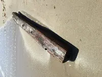
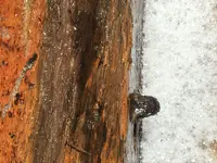
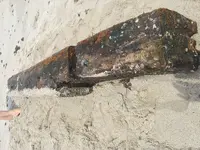
Things are getting stirred up. This 12 by 14 by 8 foot timber washed up 1 mile south from Urca de Lima, (pepper park, ft. pierce) IMG_1144.webpIMG_1152.webpIMG_1182.webp
 

Last edited:
A very good resource if you are new-ish to the Treasure Coast can be found here:
http://www.mdhtalk.org/articles/beaches/1715-fleet/1715-article.pdf

Salvaging hurricane wreckage on a windward shore never a matter of "the ship and her cargo ar located at "## ##.### Lat, ## ##.### Long. in 57 feet of water" It is a scatter...you might find a ballast pile offshore in 40 feet of water, but the wreckage 'scatters' all to hell and gone. The scatter patterns on the 1715 Fleet wrecks are indicative of the ships being blown into too-shallow water, being gutted on the limestone reef where they spilled ballast and cannon and treasure, and then pieces and parts being blown onto and up the beach to the north atop the storm surge by wind and wave action. It is possible that some were cast over the barrier island into the Indian River Lagoon, but anything inside the shallow Lagoon would likely have been salvaged easily. It is also possible that like the San Jose 1631 that wrecked in the Perlas Isles off the west coast of Panama, one or more of the 1715 Fleet may have stuck bottom far offshore, lost her bottom and then scattered ballast and treasure on the way in...we may never know...but I think we might know more at the end of this season!

Always good insight from Mr. Black!
 

Additional scatter also to the South of each Wreck when the winds changed direction on the back side of the hurricane and dragged debris in that direction as well.
 

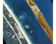
Checking with Google Earth. This is not the Cabin Wreck (Regla) which is located @ 27 49 582N. 80 25 780W which is about 5 mi north. This is the San Roman (Corrigans wreck) a little south of Wabasso Beach.
 

Did the Spanish bury their dead? After a tragedy like this, bodies were obviously everywhere.
 

When the Whydah sank in 1717 there were bodies all over the beach. After locals stripped the good stuff off them they helped bury them and then tried to get the governor of Massachusetts to pay for this "service"! If this had happened today, the great whites would have a field day, we see them out on site all the time now as the seal population continues to grow.


WD
 

Can’t blame them. I’d try to get some money out of the governor if I could! And that’s a fact. White sharks are reported all the time by fisherman here , a mile out from Rudee Inlet. Humans aren’t a natural food source(yet). When an apex predatory is hungry they’re gonna eat! Regardless of what it is.
 

There was a fatality last year about 1 mile from the site and there have been many beach closures due to those big guys.


WD
 

I was metal detecting the beach at the Green Cabin wreck site a couple of years ago when the Capitana salvage boat recovered a 1614 eight reale. Brent Brisben brought it to the beach for a TV interview and I got to see it up close. The same time they recovered a High School class ring that turned out to be lost about 40 years earlier in a burglary in Miami. They ultimately got it traced back to the original owner who now lived in Colorado. Ring returned, it's a crazy, funny business.
 

Top Member Reactions

Users who are viewing this thread

Latest Discussions

Back
Top Bottom