help with some maps please ??

centaur

Jr. Member
Joined
Feb 12, 2013
Messages
31
Reaction score
8
Golden Thread
0
Location
Greece
Detector(s) used
Minelab xterra 705 Artemis LRL
Primary Interest:
All Treasure Hunting
This is actually my first post other than an intro in the new guy thread . Please dont hold it against me for jumping right in and asking like this. My feet are tired from walking these mountains. So here goes.

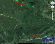
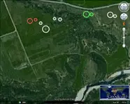
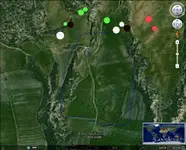
Here are two maps which I have been trying to locate caches. They may have been found by others or removed by those who buried them, I dont know this. There were signs of digging but it looked liked who ever dug, missed .
Im going with the markings I have found in the areas and forming maps of signs. I have found the old trails which led to more signs, but still nothing. Any help would be greatly appreciated. Thanks in advance. pazar 000.webp000 antartikAA.webp
 

Could I get a better view of the area in yellow?....Art

pazar%20000.webp
 

123 apol.webpArt, I cant zoom in any clearer. I could pm you the coordinates if it would help.
 

I am getting Gold Coins buried about one foot deep in a metal box...there is a marked tree..Yes..I would like to have the coordinates....Art
123%20apol.webp
 

On the second pic, the pendulum shows the four corners where the marks on the trees were. These guys were topographers. They knew their business. But odds are that what Im looking for has been moved to somewhere high nearby.
I do have my hunches, just wanted to get some other thoughts and see if Im on the right track.
 

Here is another pic with a dowsing request. This is an old Turkish village . With the population exchange in 1922,a lot of Turkish loot was hidden . There are ruins from an old mosque. There is story of someone with a map showing up and 100 paces from the old fig tree etc etc.
This is what the guy who grazes his flock of sheep up there told me.
There are also diggings with an excavator, but they missed. Ive got a good hit with the lrl in an area by the stream. If someone could verify it ,it would be greatly appreciated. The blue circle is where they excavated. Thanks napolepex.webp
 

I marked different type sites in red, green, white. It might be better to let you identify sites of interests. But, the red I got down to 8-10 ft deep, if ancient ruins are in the area could be it.
 

Attachments

  • 000 antartikAA-centaur.webp
    000 antartikAA-centaur.webp
    178.3 KB · Views: 127
  • pazar 000-centaur.webp
    pazar 000-centaur.webp
    60.1 KB · Views: 104
I think the focus of the interest is in the green and white in the pic on the right, but I notice the red is lighter in color from the left pic. Im trying to read up on your other posts and match things up in the meantime. If I could get a depth ,size and metal calculation it would be helpful. Please explain .


Much thanks
 

Last edited:
No different meaning on red color here, white is possible dig sites or even bunker/cave.....but your country and situation might have another possibility. Green archaeological type, including signs/markers or non-metallic. Black here is for precious metal, didn't seem deep enough to be an old mine or vein.
 

Some more to check, to see which sites are of interest.
 

Attachments

  • napolepex-centaur.webp
    napolepex-centaur.webp
    71 KB · Views: 113

Top Member Reactions

Users who are viewing this thread

Back
Top Bottom