Hunting fish traps?

tncreeker

Sr. Member
Joined
Feb 6, 2011
Messages
328
Reaction score
112
Golden Thread
0
Location
Maggie Valley, N.C.
Primary Interest:
Relic Hunting
Upvote 0
Lori,
Here in RI I know of one that is near the mouth of a river that flows into the Bay it is a massive one used for many years. I have found many points and flakes on the banks of the river (Both sides) right in front of the trap. It is made of stone and has two stone what look like holding pens on each side to possibly hold the fish trapped in the main part so thay could mass harvest...its awesome. I think based on this site that they spent a ton of time at these traps at certain times of the year so artifacts will be there...worth polking around I would say!

Good luck!
Lou
 

yes it is weir, have one in a river near me and like Lou said, definitely worth looking around, usually an encampment nearby and if the water's clear enough look along the upstream side of the walls for points
 

Does anyone have a picture of what these traps look like? I'm not so sure I would know one if I saw it :icon_scratch:
 

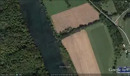
I dont know what they would look like in Ohio,,prob. pretty close to ours. Here is a GE image of one. I was shown this and told it was a weir,,,I`m not a pro. but it looks like a trap.
 

Attachments

  • weir2 (640x377).webp
    weir2 (640x377).webp
    37.8 KB · Views: 568
I have found ones made from cedar poles that are now under water and the areas around held habitation spots.... Not sure I understand the google earth image?
 

While all the questions are being posed, I'll throw one in....how could ANY man made structure, espcially one made without big equipment, survivie all the centuries of floods and nature's rearranging? If men could move a boulder or stone, water can toss it around like a volley ball..?
 

the ones here in Ct. are stone walls in the shoals of the river, the walls are pyramidal in design and although time has moved them to some extent they are still intact enough to identify them as a manmade structure. The NA's would herd the fish towards the shallow water and trap them with the walls from swimming downstream and proceed to spear as many as they could. Lori, be careful of currents and slippery rocks!!
 

TnMountains,
The water flows from the right side, the walls of the trap confine the fish as they move downstream. The gatherers are stationed at different points to spear the fish as they move down river. There is more to this trap than the image shows. There is another island upstream an obstruction that makes for a 1 way lane straight into the trap. I`ll try to get that one on here. I guess it would be like herding cattle. They used woven baskets also to scoop the trapped fish. I`ve found 3 of these on GE so far. I think this one is up by Strawberry Plains. Not all of them are this intact, but its evident what they are.
 

there are quite a few on the james river in virginia, in shoals in the piedmont region, i've never looked for points though, just seen them on canoe/kayak trips,
 

Naturegirl,

While I cannot explain the dynamics of building a weir, there are tons of pictures of them on google. They are located pretty much world wide. As far as why they still stand,,what about the pyramids, the mayan temples, etc. All built without heavy machinery. There are rock walls in Maine that are hundreds of years old that still stand. Credit to the builders of the old days.
 

tncreeker said:
TnMountains,
The water flows from the right side, the walls of the trap confine the fish as they move downstream. The gatherers are stationed at different points to spear the fish as they move down river. There is more to this trap than the image shows. There is another island upstream an obstruction that makes for a 1 way lane straight into the trap. I`ll try to get that one on here. I guess it would be like herding cattle. They used woven baskets also to scoop the trapped fish. I`ve found 3 of these on GE so far. I think this one is up by Strawberry Plains. Not all of them are this intact, but its evident what they are.

Very cool. The ones we find were late Mississipian and being from cedar in the mud they survived and are till under the water. The bases anyway. Before the impoundments the rivers were very shallow and they did herd them into weir traps and baskets. I am sure they noodled as well from all the catfish bones in the midens. Interesting areas and research. I bought all the old maps before the flooding from TVA. You can figure out sites very quickly by studying slow moving curves with shallows that had mussells and then some high ground and 9 times out of 10 it is a site . : ) Cheers and good luck in your hunts!
 

TnMountains,
Uh,,are those maps still avail.? Looks like I`m gonna be here in TN. for another year. Other than the "Debitage" place I found on accident,,,I got nothing. I have googled for maps every which way I can think of. Any advise?
Also,,,,it is the hunt,,not the ownership. I could buy all day,,,I dont. I love the hunt,,,and the occasional find :)
 

Top Member Reactions

Users who are viewing this thread

Latest Discussions

Back
Top Bottom