- #1
Thread Owner
Indiantown Gap ; & Vicinity, Indian History
Nothing Directly related to the Marquette Lake area available so far.
Soldiers who train and maneuver through the woods of Fort Indiantown Gap tread on historic around. Indian artifacts found in this area have been dated back as far as 3500 B.C.
As the settlers moved into the area of northern Lebanon County, during the early 1600’s and until the mid-1750’s, the white settlers considered the Lenie-Lenape Indians to be friendly.
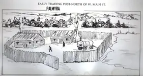
There were four Lenie-Lenape Indian villages in the vicinity of the present fort, one of which was established at the south entrance. Harper’s Tavern, located about two miles south of Fort Indiantown Gap, was built about 1740 by Adam Harper. It was sometimes surrounded by wigwams of friendly Indians who traded there
But, by the 1750’s, the Indians were being pushed farther and farther back from their traditional hunting grounds, and the French encouraged the Indians to start making attacks on the frontier settlement.
Because of these attacks, a chain of fortifications was established along Blue Mountains. The need for these forts is readily apparent when it is considered that, between 1755 and 1763, the Indians killed 123 people in Lebanon County.
Just a few miles south of the present location of Fort Indiantown Gap, in 1755, the house of Adam Reed, Esquire, was turned into a fort. Reed used this fort to protect the people of the countryside from sudden Indian attacks. One might say that Adam Reed was the first “Commander” of Fort Indiantown Gap.
The 7 ½ foot bronze, 650 pounds, statue of the woman Cuewe-Pehelle, installed at Lebanon Valley College by two longtime members of the Lebanon Valley College family, Dr. Clark and Edna Carmean. The statue is named for the original form of the word Quittaphilla -- the name of the creek that flows through Annville. Quittaphilla was the Algonquin Indians’ word for “a stream that flows from the ground among the pines”.
Source: Lebanon Daily News, 18 August 1997
1700's The known history of this area goes back thousands of years. Indian artifacts found in the area have been dated to as far back as 3500 BC
When the first settlers came to this area, several Indian villages were established around the Gap in Blue Mountain, hence the name Indiantown Gap. The fertile land of the Lebanon Valley, and the abundance of wildlife had the same attraction for the settlers as it did for the early Indians. With the fair treatment the Indians received under William Penn, the settlers and Indians co-existed peacefully at first.
However conflicts between Indian tribes and territorial disputes between European nations eventually lead to the French and Indian War. With the defeat of the British under General Braddock, the hostile Indians began attacking the settlers.
The Blue Mountain formed a natural barrier between the settled area in the rolling hills to the south and the wild mountainous region to the North. The Indians used Indiantown Gap, as well as Manada Gap to the West and Swatara Gap to the east as attack routes. The settlers built fortified barns and houses for refuge. Eventually The government in Philadelphia authorized a chain of blockhouses to be built to stem the attack and garrisoned them with soldiers. Forts were placed by each of the Gaps, the one by Indiantown Gap was known as Browns Fort. The forts were garrisoned by about ten men and were close enough that soldiers on patrol could reach the next fort by the end of the day.
One of the leaders of this time was Conrad Wieser. He had spent many years learning Indian ways and acting as a translator and policy maker during negotiations with the Indian leaders. When the Indian wars broke out in the mid 1700's Weiser organized a militia to defend the area. The State Game Lands adjacent to the north border of the post are named in his honor. The name of Fort Indiantown Gap is the legacy of at least four Indian communities that flourished in the area during the early 1700's. One village was located near what is now the north entrance to Fort Indiantown Gap, and a larger one was at the south entrance.
http://www.wwiifederation.org/igmr_history.html

Nothing Directly related to the Marquette Lake area available so far.
Soldiers who train and maneuver through the woods of Fort Indiantown Gap tread on historic around. Indian artifacts found in this area have been dated back as far as 3500 B.C.
As the settlers moved into the area of northern Lebanon County, during the early 1600’s and until the mid-1750’s, the white settlers considered the Lenie-Lenape Indians to be friendly.
There were four Lenie-Lenape Indian villages in the vicinity of the present fort, one of which was established at the south entrance. Harper’s Tavern, located about two miles south of Fort Indiantown Gap, was built about 1740 by Adam Harper. It was sometimes surrounded by wigwams of friendly Indians who traded there
But, by the 1750’s, the Indians were being pushed farther and farther back from their traditional hunting grounds, and the French encouraged the Indians to start making attacks on the frontier settlement.
Because of these attacks, a chain of fortifications was established along Blue Mountains. The need for these forts is readily apparent when it is considered that, between 1755 and 1763, the Indians killed 123 people in Lebanon County.
Just a few miles south of the present location of Fort Indiantown Gap, in 1755, the house of Adam Reed, Esquire, was turned into a fort. Reed used this fort to protect the people of the countryside from sudden Indian attacks. One might say that Adam Reed was the first “Commander” of Fort Indiantown Gap.
The 7 ½ foot bronze, 650 pounds, statue of the woman Cuewe-Pehelle, installed at Lebanon Valley College by two longtime members of the Lebanon Valley College family, Dr. Clark and Edna Carmean. The statue is named for the original form of the word Quittaphilla -- the name of the creek that flows through Annville. Quittaphilla was the Algonquin Indians’ word for “a stream that flows from the ground among the pines”.
Source: Lebanon Daily News, 18 August 1997
1700's The known history of this area goes back thousands of years. Indian artifacts found in the area have been dated to as far back as 3500 BC
When the first settlers came to this area, several Indian villages were established around the Gap in Blue Mountain, hence the name Indiantown Gap. The fertile land of the Lebanon Valley, and the abundance of wildlife had the same attraction for the settlers as it did for the early Indians. With the fair treatment the Indians received under William Penn, the settlers and Indians co-existed peacefully at first.
However conflicts between Indian tribes and territorial disputes between European nations eventually lead to the French and Indian War. With the defeat of the British under General Braddock, the hostile Indians began attacking the settlers.
The Blue Mountain formed a natural barrier between the settled area in the rolling hills to the south and the wild mountainous region to the North. The Indians used Indiantown Gap, as well as Manada Gap to the West and Swatara Gap to the east as attack routes. The settlers built fortified barns and houses for refuge. Eventually The government in Philadelphia authorized a chain of blockhouses to be built to stem the attack and garrisoned them with soldiers. Forts were placed by each of the Gaps, the one by Indiantown Gap was known as Browns Fort. The forts were garrisoned by about ten men and were close enough that soldiers on patrol could reach the next fort by the end of the day.
One of the leaders of this time was Conrad Wieser. He had spent many years learning Indian ways and acting as a translator and policy maker during negotiations with the Indian leaders. When the Indian wars broke out in the mid 1700's Weiser organized a militia to defend the area. The State Game Lands adjacent to the north border of the post are named in his honor. The name of Fort Indiantown Gap is the legacy of at least four Indian communities that flourished in the area during the early 1700's. One village was located near what is now the north entrance to Fort Indiantown Gap, and a larger one was at the south entrance.
http://www.wwiifederation.org/igmr_history.html


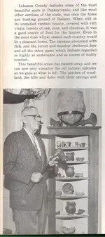

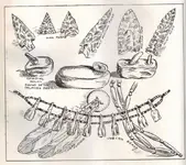
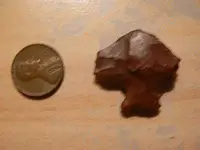
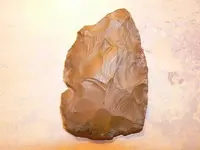
") I will post some picts of my finds after I pick my son up. Btw Behind millards quarry in annville Im searching for indian graves rumored to be there from the previous farm owners. Also I know that the highest point in palmyra sits a site if I can figure out where that is. Thanks Jeff
I will post some picts of my finds after I pick my son up. Btw Behind millards quarry in annville Im searching for indian graves rumored to be there from the previous farm owners. Also I know that the highest point in palmyra sits a site if I can figure out where that is. Thanks Jeff