You are using an out of date browser. It may not display this or other websites correctly.
You should upgrade or use an alternative browser.
You should upgrade or use an alternative browser.
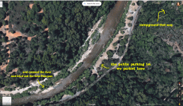
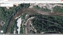
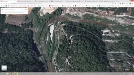
is their anybody online right now please look at the picture
- Thread starter robinredd
- Start date
- Joined
- Jun 15, 2008
- Messages
- 35,961
- Reaction score
- 19,479
- Golden Thread
- 0
- Location
- Pennsylvania (USA)
- Primary Interest:
- All Treasure Hunting

goldenmojo
Bronze Member
- Joined
- Dec 9, 2013
- Messages
- 1,869
- Reaction score
- 4,768
- Golden Thread
- 0
- Location
- N. California
- Detector(s) used
- Bazooka Prospector-Sniper-Supermini Thanks Todd & Chris, Goldhog Multisluice Thanks Doc, My Land Matters Thanks Claydiggins, 6 Senses
- Primary Interest:
- Prospecting
The corner in the pic looks like Hanson’s. It is private property and after being overrun in a 49er type deluge the last few years they are now enforcing their property rights. Downstream from that corner about a mile or so you will find the boundary marker for the park which is run by NID. You can mine from that point downstream to the day use parking lot with non engine driven equipment on the East side of the river. The West side is private property. Up until a week ago the water flow was approx 40CFS and easy pickins. NID raised it to 450CFS so now not easy pickins. Good Luck and Stay Safe.
Goldwasher
Gold Member
- Joined
- May 26, 2009
- Messages
- 6,084
- Reaction score
- 13,254
- Golden Thread
- 1
- Location
- Sailor Flat, Ca.
- 🥇 Banner finds
- 1
- Detector(s) used
- SDC2300, Gold Bug 2 Burlap, fish oil, .35 gallons of water per minute.
- Primary Interest:
- All Treasure Hunting
private land...there are only two easy public access areas to the bear.
IMAUDIGGER
Silver Member
- Joined
- Mar 16, 2016
- Messages
- 3,398
- Reaction score
- 5,195
- Golden Thread
- 0
- Primary Interest:
- All Treasure Hunting
Robin, it appears you skipped a step (finding spots to look for gold that isn't already owned by someone else).
If you ask a few questions here...you will get a pretty good education on claim/land ownership research for free.
If you ask a few questions here...you will get a pretty good education on claim/land ownership research for free.
robinredd
Tenderfoot
- Joined
- Nov 14, 2019
- Messages
- 3
- Reaction score
- 1
- Golden Thread
- 0
- Primary Interest:
- All Treasure Hunting
- #6
Thread Owner
The corner in the pic looks like Hanson’s. It is private property and after being overrun in a 49er type deluge the last few years they are now enforcing their property rights. Downstream from that corner about a mile or so you will find the boundary marker for the park which is run by NID. You can mine from that point downstream to the day use parking lot with non engine driven equipment on the East side of the river. The West side is private property. Up until a week ago the water flow was approx 40CFS and easy pickins. NID raised it to 450CFS so now not easy pickins. Good Luck and Stay Safe.
Yeah I found out I didn’t hear anything by the time we left back on the website i saw all the private property signs it sure look nice on Google maps , so from there I just punched in on my phone the bear river campground and went from there down there I should’ve known . Oh and by the way I just realized I had put Coloma it wasn’t Coloma i meant Colfax. Down The parking lot by the campgrounds we put on our waiters and cross the river to see on the picture where we went can we use the flow pan and brought home a bunch of concentrates still got to go through no I was curious we had went to Home Depot and bought a PVC tubing and then another piece that would go inside that PVC tubing and put a plunger on the end of it and we were using that down there to suck up some of the gravel and squirt it into the 5 gallon bucket you just pull the one tube by hand and it sucked up a little bit of the gravel off the bottom is that legal I don’t know
 oh mt god i just read your post again we went across but was not on the land part we were in the water were the bedrock is . what is the nid
Last edited:
Goldwasher
Gold Member
- Joined
- May 26, 2009
- Messages
- 6,084
- Reaction score
- 13,254
- Golden Thread
- 1
- Location
- Sailor Flat, Ca.
- 🥇 Banner finds
- 1
- Detector(s) used
- SDC2300, Gold Bug 2 Burlap, fish oil, .35 gallons of water per minute.
- Primary Interest:
- All Treasure Hunting
Nevada Irrigation District
goldenmojo
Bronze Member
- Joined
- Dec 9, 2013
- Messages
- 1,869
- Reaction score
- 4,768
- Golden Thread
- 0
- Location
- N. California
- Detector(s) used
- Bazooka Prospector-Sniper-Supermini Thanks Todd & Chris, Goldhog Multisluice Thanks Doc, My Land Matters Thanks Claydiggins, 6 Senses
- Primary Interest:
- Prospecting
Robin. Cleaning out a bedrock pocket with a slurp gun is the way to go. The most effective miners on the Bear wear a wetsuit and mask so the can see everything in the pocket. Everyone here likes gold pics so post one of your finds.
against the wind
Platinum Member
- Joined
- Jul 27, 2015
- Messages
- 24,797
- Reaction score
- 24,982
- Golden Thread
- 0
- Location
- Port Allegheny, Pennsylvania
- 🏆 Honorable Mentions:
- 1
- Detector(s) used
- E-trac, Excalibur, XP Deus, & CTX 3030.
- Primary Interest:
- All Treasure Hunting
Welcome to the forum from Port Allegheny, Pennsylvania
Mekong Mike
Hero Member
- Joined
- Jul 22, 2013
- Messages
- 738
- Reaction score
- 704
- Golden Thread
- 0
- Location
- Vietnam, Saigon
- Primary Interest:
- All Treasure Hunting
The bend in the river will catch gold, also around large rocks, boulders.
Private property will be your biggest obstacle.
Private property will be your biggest obstacle.
Similar threads
- Suggestion
- Replies
- 15
- Views
- 951
- Replies
- 1
- Views
- 494
Users who are viewing this thread
Total: 1 (members: 0, guests: 1)


