Langola Ghost Town

Gypsy Heart

Gold Member
Joined
Nov 29, 2005
Messages
12,686
Reaction score
352
Golden Thread
0
Location
Ozarks
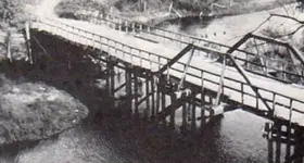
The Town of Langola - 1910
Location: Highway 10 and half way crossing, take left or right
follow until you arrive at bridge. You're there!.

From 1854 to the 1860's once stood a thriving town along the banks of the Platte river. This little town was once named "Platte River," but later change to, "Langola". The water power on the Platte river was improved by the building of a dam. A flour and saw mill was built, later stores where added, a hotel, Indian trading post, blacksmith shop and many homes. After years of great growth, high waters came, the dam broke and the town was washed away. The town was never rebuilt
 

Attachments

  • Langola Hwy 10 and half way crossing  Bridge 1910.webp
    Langola Hwy 10 and half way crossing Bridge 1910.webp
    17.9 KB · Views: 763
Thanks again Gypsy, found the site on google earth. Looks like
private property. A trip next summer might be in order!! :)
 

I've heard of it but never checked it out. This place is only about 8 miles from me. I'll research it shortly and find out who owns the land. Goose-0
 

I was wondering about the research on this property? Has anyone found anything on it? I have been hitting a couple of older town hall's in the southern half of Minnesota and so far a couple of wheatie's and a nice comme coin from the 1890's

Happy Hunting
Twin Digger's
 

I just looked at some of my old maps and I know where it might be now. Going N on Hwy 10, one should turn left on county road #40 and go to the Platt river. I think there is private camping there now, but I'll take a look. I'll take a run at it this week.
 

did you ever head out there? It would be interesting what an old washed away town turns up.
 

Sorry, I never got to look at it. I'll make a note to look for it this winter. I have a 4 WD with a 5 speed so I shouldn't have any trouble.....zoom, zoom!!
 

WOW, look what I found.....after 3+ yrs of my 'neglect' for not following through......been quite busy, Australia, Ireland, Bali, Tasmania, New Zealand, and Israel. I believe I know where this place is and there is no camping area here as I had previously mentioned. I'll definitely drive out to this place on Thur, 3-28-13. Benton county Rd #40 goes west from Minn. Hwy #10 to and over the Platte River. I'll look around and see if I can find any rubble of any type. I now have a 4WD with a 6 speed (manual) tranny.....zoom-zoom!
 

So I jumped the gun by a day. I did drive out to where I thought it might be....I saw nothing due to 20" of snow on the ground. Now I'm wondering if 'Langola' might be approx. 1 mile directly south at a large (60 acres) camp ground with many, many travel trailers (parked for the winter). This area is where the Platte River empties into the Mississippi River. I'm thinking that explorers were traveling the Mississippi River and saw this area where the Platte River empties into the Miss. River and thought it was a good place to settle. I'll look at this campground area again this summer.
 

Goose, did you find anything interesting??
 

No. I've come to the conclusion that the campground with the parked trailers by the merger of the Platt into the Mississippi river is where Langola was. I'm assuming that Benton Hwy 40 follows where the old bridge was. In the picture above you are looking S E, as the land on the west side of the river is much higher. I should approach the campground mgmt and ask if I could detect. Yeah, I will when summer comes.....it's 11:40 pm now and the temp is -17 F with around 13" of snow on the ground.
 

Goose-O
Is this the place you checked out? Any way Langola was formerly known as Sand Prairie and had a rail road at one time. So it's confusing and the town Platte River must be near the Two Rivers campground at Royalton , Mn. I might have read about this in an old treasure magazine and the safes could still be laying out there buried in the sand from the flood.

https://www.google.com/mapmaker?ll=...id=1389988733840&source=mapseditbutton_normal
 

Last edited:
it appears that one this map it looks like the road once went through the trees across the creek
 

R D, thanks for the detailed map. I'll do a little more research on this.
According to the map that R D posted, the blue line leading to a location might be the Langola township bldg which is east of the Mississippi River. I know that the Langola ghost town was west of the river possibly at the confluence of the Platt and Mississippi rivers.
 

Last edited:
So did you ever find it?
 

I think I did. It's at a large (40 acres-?) campground with permanent large travel trailers and a tent camping area. Right to the N W of the campground is the Platt River on the edge of this campground. I would have asked the mgmt if I could detect around the area, but I had a large old neighborhood street tear up of 2.25 miles (4.5 miles both sides) to detect last summer......and in 2015, the remaining tear up of 1.5 miles (3 miles both sides). Then there is also another section of an old neighborhood tear up (2 miles-?) next to the county fairgrounds (1912) scheduled to be torn up this coming yr.
 

So how did you do at the tear up? We had one in st paul and i didnt find anything good
 

Pretty good. I was there from May to the 1st week of August. My detecting finds were I H cents-'97, '01, '03, '04 / V nickels-'88, '00 / Buffalo nickels-'15-D, '18, '27-D, '37 / Jefferson nickels / '43-D, '44-S (War-35% silver) / Seated Lib dime-'87 / Barber dimes-'03, '14 / Merc dimes-'43-S, '44-D. Also a 1900 Canadian dime-(Sterling silver) I also found a large 1-1/2" brass tax token...."Pay Cashier-50-Joe Meyers". I researched it and found out that Joe Meyers was Morrison's County Treasurer (Little Falls) from 1901 to 1909. I donated it to the Morrison County's museum....in which they knew nothing about any such token and they were very thankful.
 

Wow that is pretty awesome!!! The tearout here was so fast it was easy to miss the good prospects.
 

Top Member Reactions

Users who are viewing this thread

Back
Top Bottom