So does it chart out a 3D plot of the ground? Kind of like GPR?
3D image yes, but the plotting isn't as great.
There are basically 3 different types of imaging available and all results can be saved, but what is dumb is the data can not be transferred to a smart phone or even a computer!!!
Type 1 shows a linear plotting with either:
- Single/multiple cavities below;
- Single/multiple objects below;
- Mixture of objects and cavities.
Type 2 Is not automatic like GPR as it requires you take a manual measurement of the width of the target's signal which is entered on the screen/controller and subsequently indicates the depth but will shows a color image representing only metallurgical composition. Unfortunately, Type 2 can only provide one target depth plot at a time.
I like the depth analysis feature, as it prevents me from starting what I thought would be a quick dig but instead turns into buckets and buckets of dirt later. Man that was a good day not at work...lol. However, taking the measurements is no easy chore when you are alone and are wearing all the equipment.
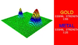
Type 3 is short and sweet. You sweep and scan at the same and it gives you a nice visual indicator to go along with the music..lol It shows you a percentage of content.
Naturally it isn't perfect because of halo effects and such. I like it though as I can stake/flag the little stuff and spend my little available time on the "interesting" targets first.
Unfortunately, the internet has hundreds of the same dumb promotional videos that suck and do not really show anything.
I am posting a generic pic from a Type 3 result from Deephunter's book to give you an idea. I will try to take some Type 1&2 pics once I find something interesting.