Ground penetrating radar (GPR) is very accurate for detecting cavities. GPR is the highest resolution geophysical method, unfortunately it is also the most site dependent. The attenuation of the GPR signal can make GPR completely useless at some sites. In the USA, the United States Department of Agriculture (USDA) has the web soil survey website shown at the link below. You click the big green button at the top of the screen, then go select an area of interest (AOI), and then select GPR soil suitability from the menu. It will give you an idea if GPR will work at your site.
The Natural Resources Conservation Service is the Federal agency that works in partnership with the American people to conserve and sustain natural resources on private lands.

websoilsurvey.nrcs.usda.gov
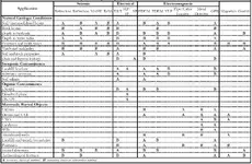
ASTM Standard D6429 Standard Guide for Selecting Surface Geophysical Methods suggests that Electrical Resistivity Tomography (ERT), gravity, and ground penetrating radar are the preferred methods for void detection. Which method your select depends on the target size, depth, and geologic material properties. For drug tunnel detection on the USA/Mexico border we used a number of methods, but you need to realize that a drug tunnel while a void at depth has other properties that can make it a better target than a mostly air filled cavity. Drug tunnels, or any tunnel for that matter, have to cross some boundary. The boundary can be a border, it can be the fence line of a military base or prison, or any other border. Typically the tunnel is perpendicular to the border to minimize the tunnel length. Drug tunnels usually have electrical wiring for lights or ventilation, they may have pipe systems to remove water, they may have other infrastructure. All of these pieces of infrastructure can be a better target than the air filled void. The tunnels also need to be dug, so we can listen for the digging sounds and locate them. We often used passive seismic arrays to locate the active digging, or active seismic arrays to locate the existing tunnels. As you can see from the table, seismic methods are a B and not an A for ideal method, but they often worked in these specific locations.
So, the general answer is that there are a lot of methods that may work but they are all site dependent.
If you watch the TV show I was on, I did an ERT survey to locate a cave about 100 ft below the ground surface.
A&E Television Networks, LLC
The History Channel
Lost Gold of the Aztecs, A Hidden Chamber S01E06
Episode aired Tuesday, May 10, 2022 at 10/9c
https://www.history.com/shows/lost-gold-of-the-aztecs
GPR can penetrate to 30 m (~100 ft), but usually won't due to the electrical conductivity of the soil. Also, the units that can image that deep are lower frequency systems (< 100 MHz center frequency) so have lower resolution. Using my ImpulseRadar CrossOver CO1760 GPR unit (170 & 600 MHz frequencies) I have penetrated to 15 m (~50 ft) at a few sites.
GPR penetration is affected by the electrical conductivity of the soil. This is the material property that controls attenuation. Density has nothing to do with it. Generally, wetter soils or rocks have higher electrical conductivity and therefor higher attenuation. But, I can use GPR on a freshwater lake to do bathymetry and map the bottom of the lake and materials beneath the bottom.
So in summary, if you have low attenuation at a site then GPR is the best method. If you have high attenuation, then GPR may not work at all and you will need to pick another method.