River Banks Yes or No

OH..POPS

Full Member
Joined
Dec 18, 2021
Messages
144
Reaction score
290
Golden Thread
0
Location
Medway Ohio
Detector(s) used
Pops old one
Garrett Ace 400
Bounty Hunter
Sharp Shooter II
Primary Interest:
Metal Detecting
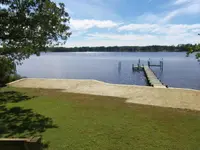
I own a 16ft bass boat and live near the Cumberland River. There's a lot of man made dams and reservoirs. One particular spot is where a Fort was located. Fort Blunt is what i'm talking about there was also a river trolly later built after the Fort was built. If I beach my boat on the river bank would I legally be able to hunt the river bank on both sides where the trolly boat crossed the river?
 

Upvote 1
You can in Virginia IF you stay BELOW the high water line/mark of that steam/creek/river . All states have different laws about this .Best to check yours first.
 

In Virginia, law authorizes private landowners to control land down to the MEAN LOW WATER MARK. just for clarification ....... 1819 law passed by the General Assembly
 

I alway anchor my boat, just off shore..in waist deep water.... with two anchors.. I'm in the Chesapeake Bay. Just a tip . Here I often get someone that wants to know what I'm doing..(Land owner) sometimes that can go good, sometimes not so good. So I now carry the DNR (Department of Natural Resources Police) telephone number. It has saved me a few times when the landowner may get upset or even call the local police.

Some may say it is best to leave and come back another day but once you do that they will think you were doing something wrong and will watch for you or alert the neighbors to watch for you. Best to deal with it the first time and let them know who is right....

Also if you have a video cam, turn that baby on once you anchor, a few years ago I had someone come down jump in the water and was swimming around. They never came near me but little did I notice they disconnected the fuel line from the motor...then stuck it back in but not clicked in.. I started the boat..pulled out a few hundred feet. Boat cuts off. Had it towed, thank god for tow insurance.. Got back to the docks and see the fitting was loose.. connected it, started right up.. Now I have video cam on my boat, running while I'm in the water.

21a.webp
 

I've done a little checking and found out that there's two places I need to check with. One is the Tennessee Valley Authorities and the U.S. Army Corps of Engineers. The U.S. Corps control the flood and reservoir part of the Cumberland River is probably the ones I need to talk to. From the old times here they tell me any thing below the water line is okay
 

I've done a little checking and found out that there's two places I need to check with. One is the Tennessee Valley Authorities and the U.S. Army Corps of Engineers. The U.S. Corps control the flood and reservoir part of the Cumberland River is probably the ones I need to talk to. From the old times here they tell me any thing below the water line is okay
Corps can be tricky to deal with depending on the particular person you get. Most of the old school guys don,t care much so long as you,re not breaking any Corps regs. A lot of the younger ones come from the don,t touch it school of thought and go out of their way to find some reg you,ve broken.That,s been my experience on the Arkansas River at least. Keep a low profile.
 

Patuxent ?
Me, I was up the Magothy river... towed me 10 miles back to sandy point state park.... Said it would have cost me 700 dollars if I did not have U.S. Boats.. last I checked I pay 175.oo a year for tow and help. Took them 35 minutes to get to me...Not bad at all.
 

RIPARIAN RIGHTS: It is very complicated, and usually You will need a Attorney specialized in RIPARIAN RIGHTS to navigate threw the wordings. The States of Delaware, Maine, Massachusetts, Pennsylvania, and Virginia, it is the mean low tide line that demarcates the public from private land. In other words, only the land below the average shoreline formed at low tide belongs to the public, and private owners can own land all the way down to that shoreline.

I have put in a few bulkheads and piers, and groins along the tidal rivers of the Chesapeake Bay. Paperwork and permits take more time to complete than the actual job. All our measurements need to be in compliance with the Chesapeake Bay act, Tennessee Valley Association, Army Corp of Engineers, County of property, etc. So our drawings and plat measurements come off mean low tide. From there all the stakeholders and agencies either approve or decline the project.
 

Attachments

  • 14481944_10209210247870852_2066318300790665140_o.webp
    14481944_10209210247870852_2066318300790665140_o.webp
    158.5 KB · Views: 38
  • 14692187_10209388963778638_3165247214507679613_o.webp
    14692187_10209388963778638_3165247214507679613_o.webp
    177.8 KB · Views: 38
Last edited:
I'm not talking about "Tidal Waters"
008.webp
 

Last edited:

Top Member Reactions

Users who are viewing this thread

Back
Top Bottom