EDN
Jr. Member
- Joined
- Apr 17, 2016
- Messages
- 58
- Reaction score
- 131
- Golden Thread
- 0
- Location
- Gilbert, Arizona
- Detector(s) used
- Minelab Eureka Gold
- Primary Interest:
- All Treasure Hunting
- #1
Thread Owner
Does anyone know about trails that went along the Salt River before the Dams were built?
I have read many stories describing a crossing where cottonwood canyon meets the salt. They would travel up to tortilla pass and other canyons heading south. I have read Waltz came down cotton wood canyon from hidden water to the salt, but could he and other come up the salt from the west? What about trails along the salt traveling east from Stewart Mountain Dam ( 33.566384°, -111.535617°) to the point the Cottonwood Canyon dumps into the Salt ( 33.565321°,-111.464715°)?
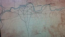
I seen on an old map of a ranch this should be under water now at around this location ( 33.564061°, -111.516465°).
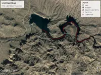
I attached a picture from Google Earth.
Thanks,
EDN
I have read many stories describing a crossing where cottonwood canyon meets the salt. They would travel up to tortilla pass and other canyons heading south. I have read Waltz came down cotton wood canyon from hidden water to the salt, but could he and other come up the salt from the west? What about trails along the salt traveling east from Stewart Mountain Dam ( 33.566384°, -111.535617°) to the point the Cottonwood Canyon dumps into the Salt ( 33.565321°,-111.464715°)?
I seen on an old map of a ranch this should be under water now at around this location ( 33.564061°, -111.516465°).

I attached a picture from Google Earth.
Thanks,
EDN


