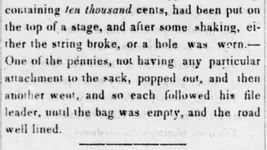
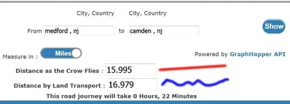
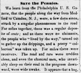
up to 16 Miles ? 10,000 Large Cents scattered from Medford to Camden in 1845

jeff of pa

Super Moderator
⛭ Moderator
🥇 Charter Member
Joined
Dec 19, 2003
Messages
90,061
Reaction score
65,686
Golden Thread
2
🥇 Banner finds
1
🏆 Honorable Mentions:
1
Primary Interest:
All Treasure Hunting
Almost 200 years have gone by, but If you can find the Likely Route.
And if Curves have been Cut off, Pre-Black Top Days.
there may be one or more still out there in Fields, or wooded areas
just a few feet off the Present road.


Jeffersonian Republican.
(Stroudsburg, Pa.), 23 Oct. 1845.
000aaa.webp
000bbb.webp

000ccc.webp

https://chroniclingamerica.loc.gov/...=&proxValue=&dateFilterType=yearRange&page=12
 

Last edited:
Should be easy enough to find the old route, if there are old aerial photos of the area like we have for PA.
 

yep !
also any old County AtlaS Like "BEERS" Will show you the Most Direct (Shortest) Route.
Which would most likely have been taken.

Most Direct Route is Probably the one on the .
NEW JERSEY STATE MAP 1872

https://mapmaker.rutgers.edu/1872Atlas/NJ1872.jpg

if a major turn were Needed,
1872 county maps
[SIZE=+2]1872 ATLAS OF NEW JERSEY by F.W. Beers[/SIZE]

https://mapmaker.rutgers.edu/MAPS.html#Anchor-1872-49575

Also, there may be Dept. of Transportation Maps of Each Township,
from the teens and 1940's Like PA Has, Which Would get you Even Closer.

Old Historical City, County and State Maps of New Jersey - Map Geeks


https://mapgeeks.org/newjersey/
View Maps of New Jersey such as historical county boundaries changes, old ... The New Jersey D.O.T. Highway Department has prepared a series of 2016 ...


https://mapgeeks.org/newjersey/


Then... From there Comparison to an Early Aerial & recent Aerial Should show any Major
Changes.
 

Last edited:

Top Member Reactions

Users who are viewing this thread

Latest Discussions

Back
Top Bottom