Complete Map Dowsing Project

Cochetopa

Jr. Member
May 2, 2009
65
23
Galt's Gulch, Colorado
Detector(s) used
Minelab Eureka Gold
Primary Interest:
Prospecting
Hi,

I want to share with everyone a map dowsing process I am using. It may sound convoluted to you, but it helps me avoid becoming emotionally entangled in a project to the detriment of my objectivity.

A) Create a numbered list (Excel) of targets for which I would like to map dowse. For this specific project my list was:
1. ore deposit
2. nugget shooting
3. coin shooting
4. coins
5. mineral deposit
6. dore
7. meteorite
8. historical artifacts
9. Indian artifacts
10. cash
11. cave
12. gemstone
13. fossils
14. petrified wood
15. booty
16. contraband
17. hoard

B) Make 5 or 6 versions of this list, but in different sequences. Print a hardcopy of each list, fold each list in two, with eyes closed shuffle the pile of lists to where I no longer know which is which, and select one of the lists to use, but don’t look at its contents. The chosen list becomes my list of potential targets. I hold this list in one hand during steps C through F.

C) I placed a pile of folded, closed maps in front of me and asked, “Is there a TARGET from the list in my hand that is located on one of these maps which you want me to have now?” My dowsed answer was, “Yes”, so I continued.

D). Divide the map pile into two smaller piles, and ask, “Which map has the location of the TARGET you want me to have now?” Observe my instrument react to one of the two piles and eliminate the other. Divide the selected map pile into two smaller piles, etc. and iterate the process until a single map is identified. (This map pile technique isn’t my idea; it was my dowsing mentor’s, Sam Wolfe.)

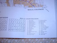
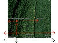
E) Open up the chosen map and dowse the TARGET location. The map in this project was a US Forest Service map, which had too coarse a scale for my skill level. So, I dowsed an approximate location from it, and then purchased a more detailed 1:24,000 scale USGS topographic map that covered the area in question. (You can order USGS maps here, The USGS Store - One stop shop for all your maps, world, United States, state, wall decor, historic, planetary, topographic, trail, hiking, foreign, satellite, digital ) I dowsed the specific TARGET location on this topographic map.

F) At this point I finally dowsed asking the question, “What is the number of the TARGET on this list in my hand which you want me to have now?” The answer I determined using a simple numerical chart I drew on a white board, was “9”, for Indian artifacts. Until now, I had been dowsing only for the TARGET for which I had asked back in step C. In fact, I had been envisioning only the word, “TARGET”, in my mind during steps D and E. In this way I was prevented from polluting my search project with mental implants, past personal history, known geographic place names, and treasure stories from books and magazines.

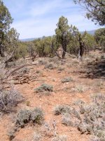
F) A few weeks later, I drove to the TARGET location that was outside the town of Nucla in southwestern Colorado.

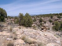
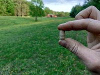
G) After driving as far as I could, I hiked to the location indicated on my topographic map and started looking on the ground for anything “unusual”. After about 10 minutes, I noticed a small, beige-colored rock that was out of place visually; it didn’t belong with the eroding mud and sandstone mesa material that was everywhere. I picked it up and identified it as flint, the material Indians made into knives, scrapers, arrowheads and spear points. (You can read about the Anasazi culture here, Ancient Pueblo Peoples - Wikipedia, the free encyclopedia ). So, I decided I needed to look for more flint, and 5 minutes later located my first loose agglomeration of flint shards left behind 100s of years ago by someone fabricating stone tools chip-by-chip-by-chip... I found 3 or 4 more similar sites in the next half-hour just walking around.

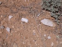
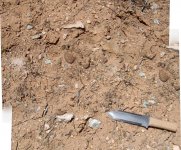
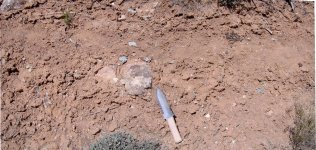
I have attached a couple of close-up photos of what the ground looked like where scattered flint chips could be observed. Also, I’ve included a portrait snapshot of one of the flint sites, the foreground light colored rocks are the flint debris left behind by Indian craftsmen from centuries past. Remember that these artifacts are protected by the Antiquities Act, so take only pictures and leave only foot prints.

There you have it, a complete map dowsing project. I hope you have enjoyed something from it, and feel free to adopt the technique for your own, or ignore it, as you choose.

Sincerely,
-C
 

Attachments

  • FlintChipsSite1R.JPG
    FlintChipsSite1R.JPG
    231.7 KB · Views: 306
  • FlintChipsSite2.jpg
    FlintChipsSite2.jpg
    291.5 KB · Views: 259
  • FlintChipsSite3.jpg
    FlintChipsSite3.jpg
    323 KB · Views: 210
  • FlintChipsSiteTypical.JPG
    FlintChipsSiteTypical.JPG
    220.6 KB · Views: 269
OP
OP
Cochetopa

Cochetopa

Jr. Member
May 2, 2009
65
23
Galt's Gulch, Colorado
Detector(s) used
Minelab Eureka Gold
Primary Interest:
Prospecting
Hi, again,

While hiking back to my car on this trip, I came across a stone(s) marker out in the middle of nowhere. I have no idea what it’s all about, but I do know there is interest in this forum for markers, so am belatedly mentioning it now. A photograph is attached.

Sincerely,
-C
 

Attachments

  • SV400047.JPG
    SV400047.JPG
    221.6 KB · Views: 333

Red_desert

Gold Member
Feb 21, 2008
6,852
3,500
Midwest USA
Detector(s) used
Garrett Ace 250/GTA 1,000; Fisher Gold Bug-2; Gemini-3; Unique Design L-Rods
Primary Interest:
All Treasure Hunting
I like to keep various flint objects, ones with sharp edges, on my bookshelf.
 

OP
OP
Cochetopa

Cochetopa

Jr. Member
May 2, 2009
65
23
Galt's Gulch, Colorado
Detector(s) used
Minelab Eureka Gold
Primary Interest:
Prospecting
Red_desert,

I think I know how you feel. Just touching the flint shards take me back in time. The blue rock shown in photographs has inclusions of brown, foreign material which affects the overall rock strength. It breaks unpredictably because of the (foreign) weaknesses. I found an almost complete blue spear point which had fractured down the center axis ruining it. I can imagine the disappointment the craftsman might have felt when he saw his work break into two pieces.

-C
 

Red_desert

Gold Member
Feb 21, 2008
6,852
3,500
Midwest USA
Detector(s) used
Garrett Ace 250/GTA 1,000; Fisher Gold Bug-2; Gemini-3; Unique Design L-Rods
Primary Interest:
All Treasure Hunting
Red_desert,

I think I know how you feel. Just touching the flint shards take me back in time. The blue rock shown in photographs has inclusions of brown, foreign material which affects the overall rock strength. It breaks unpredictably because of the (foreign) weaknesses. I found an almost complete blue spear point which had fractured down the center axis ruining it. I can imagine the disappointment the craftsman might have felt when he saw his work break into two pieces.

-C
We have some types of white flint with brown inclusions, perhaps more of a chert. Then the shards usually are of a darker gray inclusions, even sometimes layered or banded containing a few swirls.
 

Red_desert

Gold Member
Feb 21, 2008
6,852
3,500
Midwest USA
Detector(s) used
Garrett Ace 250/GTA 1,000; Fisher Gold Bug-2; Gemini-3; Unique Design L-Rods
Primary Interest:
All Treasure Hunting
This is what I found, a whole flint without any chipping work done on it yet.

flintrock1.JPG

Closer view of grayish inclusions. The very bottom has some obvious weakness, would break if used.

flintrock2.JPG

A small sharp piece from my bookshelf.

flintsharp1.JPG

Another angle of the same.

flintsharp2.JPG

Edges of it.

flintsharp3.JPG

Last view on end.

flintsharp14.JPG
 

Last edited:

teleprospector

Silver Member
Jul 8, 2007
3,794
4,134
The Motor City
🏆 Honorable Mentions:
25
Detector(s) used
Extended Sensory Perception, L-rod, Y-rod, pendulum, angle rods, wand.
White's MXT, Garrett Ultra GTA 500, AT Gold, SCUBA Detector Pro Headhunter, Tesoro Sidewinder, Stingray, 2 box-TF900, Fisher TW-6
Primary Interest:
All Treasure Hunting
Hi Cochetopa,
I enjoyed reading your map dowsing technique. In addition to your field dowsing I feel you would be a really good teacher.
Jon
 

OP
OP
Cochetopa

Cochetopa

Jr. Member
May 2, 2009
65
23
Galt's Gulch, Colorado
Detector(s) used
Minelab Eureka Gold
Primary Interest:
Prospecting
Hi, Jon,

Thank you for your nice remarks. Actually, I was involved with education during the last years while I was working. I am retired now.

I think that in the back of my mind this post was meant to be the first of two parts. I feel an urge to also explain the rationale why the map dowsing procedure developed the way it did. It wasn’t by accident, but has a solid justification IMHO.

Anyway, that’s where I am headed.

Sincerely,
Cochetopa/Jim
 

MrBalance

Jr. Member
May 6, 2012
66
7
Primary Interest:
All Treasure Hunting
Respected Cochetopa,

The idea of using cards to avoid emotional connection with target is very brilliant.

Question for you and other dowsers:


C) I placed a pile of folded, closed maps in front of me and asked, “Is there a TARGET from the list in my hand that is located on one of these maps which you want me to have now?” My dowsed answer was, “Yes”, so I continued.

This is the key in your process.

Cochetopa do you think pyhsicall maps can be totally replaced by google arials and IRL site photos?

I suppose using Google aerials is superior to printed maps (especially when you do not have maps) how would you suggest to achieve that split testing in Google maps:

I was trying to find a program that would impose a good "dowsing" grid on google maps (Googles built in grid is not good for that purpose), my second idea is to make a physical tin wire grid and to put it on computer screen.

Then I would zoom in and out of Google maps as I see fit.

Has anybody put a physical thin wire grid on computer screen?

If so which size of grid and screen size/resolution would be best.
 

Last edited:

aarthrj3811

Gold Member
Apr 1, 2004
9,256
1,169
Northern Nevada
Detector(s) used
Dowsing Rods and a Ranger Tell Examiner
I put the Google maps into a program called Microsoft Digital Image Pro 9..I can then zoom in and out, crop, change the Brightness and insert lines to make grids..,.Art
 

OP
OP
Cochetopa

Cochetopa

Jr. Member
May 2, 2009
65
23
Galt's Gulch, Colorado
Detector(s) used
Minelab Eureka Gold
Primary Interest:
Prospecting
Hi, MrBalance,

I have thought about your question and cannot find a way in which online earth photos could replace paper maps. The procedure relies on concealing physical details from a dowser’s thought processes to maintain objectivity until the end. A photograph displayed on a monitor in plain sight before you is at odds with that fundamental principle.

However, I do sometimes employ a grid in the procedure in a different way. US Bureau of Land Management (BLM) “Surface Management” maps are scaled to enclose a 4x8 grid of thirty-two 1:24,000 scale USGS topographic maps. The grid is always numbered 1 to 32. If the map selected from the pile in step D is BLM, I draw a linear 1-32 scale on a white board and dowse the cell number of the topo map which contains my TARGET. Then, it’s just a matter of downloading that map from the website in step E.

I have attached an image of the 4x8 grid in a BLM map’s legend, so everyone can see what I am trying to describe.

I hope this helps. Good luck with your work.

Sincerely,
Cochetopa/Jim
 

Attachments

  • TopoMapsGridLegend.JPG
    TopoMapsGridLegend.JPG
    129 KB · Views: 419

MrBalance

Jr. Member
May 6, 2012
66
7
Primary Interest:
All Treasure Hunting
Thank you both for these answers.

The non-biased decision process and the computer program are a mayor asset to all dowsers.

I assume that arial photo is always better than a map, because it is more close to reality.

That means that dowsers should work in pairs.
One would prepare the arials of an area for the other to dowse.

So, if you need an area prepared just PM me.
 

woof!

Bronze Member
Dec 12, 2010
1,185
413
ciudadano del universo, residente de El Paso TX
Detector(s) used
BS detector
Primary Interest:
Other
In order to maximize blinding (non-bias) when map dowsing, what I've done is to print out or photocopy the map, then turn it upside down and dowse the blank side. Mark the interesting spots on the back side, then turn it over and look at a window or lamp through it to see where the marks are on the terrain.

--Dave J.
 

Red_desert

Gold Member
Feb 21, 2008
6,852
3,500
Midwest USA
Detector(s) used
Garrett Ace 250/GTA 1,000; Fisher Gold Bug-2; Gemini-3; Unique Design L-Rods
Primary Interest:
All Treasure Hunting
Something that has worked good for me (when dowsing for others privately), is GE maps darkened so you can't tell what anything is visually. I've been able to dowse and mark them the same way as the normal GE maps. I don't think it would hinder dowsing efforts, if darkened GE maps were used sometimes in the dowsing threads here.
 

coyote3

Full Member
Apr 12, 2012
160
26
Wyoming
Detector(s) used
Whites XLT Spectrum,
Minelab Xterra 705,
Whites TM808,
Bounty Hunter,
Si Go by Fitz
L Rods
Primary Interest:
All Treasure Hunting
Jerry Nokes has a great way to grid your screen that I have used. It is quite easy to make and inexpensive along with being able to remove from the screen to use for daily use.
 

OP
OP
Cochetopa

Cochetopa

Jr. Member
May 2, 2009
65
23
Galt's Gulch, Colorado
Detector(s) used
Minelab Eureka Gold
Primary Interest:
Prospecting
woof!/Dave and Red_desert,

Dave: I have already tried what you describe and it doesn’t work for me. My mind is compelled to guess something about the other side of the map from subtle, visible indications, e.g. a crumpled edge, ink bleeding through the paper, etc. I am unable to turn it off. The problem does not go away if I put another piece of paper over the overturned map, or if I ask my wife to come in and perform the blinding for me. Maybe it’s just me, and the idea would work for someone else.

Red_desert: I haven’t tried dowsing directly from an image on a CRT screen. A while ago, Arthur described his technique, and I’d like to try it someday. Right now, I am having too much fun with maps and my blinding technique of shuffled spreadsheets containing shuffled enumerated TARGET lists.
 

Red_desert

Gold Member
Feb 21, 2008
6,852
3,500
Midwest USA
Detector(s) used
Garrett Ace 250/GTA 1,000; Fisher Gold Bug-2; Gemini-3; Unique Design L-Rods
Primary Interest:
All Treasure Hunting
In order to maximize blinding (non-bias) when map dowsing, what I've done is to print out or photocopy the map, then turn it upside down and dowse the blank side. Mark the interesting spots on the back side, then turn it over and look at a window or lamp through it to see where the marks are on the terrain.

--Dave J.
On printed maps, I found pendulum dowsing would leave places not yet marked. Turning the map upside down is a good idea. The far side of a map usually is slower in dowsing than the front half. You can keep rotating the map until all areas are completely covered. I suppose it could work flipping a map over too, dowse it from the back side. Just poke a hole through the X, so the spot can be seen on the map.
 

Red_desert

Gold Member
Feb 21, 2008
6,852
3,500
Midwest USA
Detector(s) used
Garrett Ace 250/GTA 1,000; Fisher Gold Bug-2; Gemini-3; Unique Design L-Rods
Primary Interest:
All Treasure Hunting
woof!/Dave and Red_desert,

Dave: I have already tried what you describe and it doesn’t work for me. My mind is compelled to guess something about the other side of the map from subtle, visible indications, e.g. a crumpled edge, ink bleeding through the paper, etc. I am unable to turn it off. The problem does not go away if I put another piece of paper over the overturned map, or if I ask my wife to come in and perform the blinding for me. Maybe it’s just me, and the idea would work for someone else.

Red_desert: I haven’t tried dowsing directly from an image on a CRT screen. A while ago, Arthur described his technique, and I’d like to try it someday. Right now, I am having too much fun with maps and my blinding technique of shuffled spreadsheets containing shuffled enumerated TARGET lists.

Most times now, computer dowsing for me is done with a small light pair of 3/32" bronze bent without handles. The ends draw together on a pinpoint.

However, pendulums will work fine on a computer screen also. The method is very similar to my L-rods technique. The photo included here, show a black double ended arrow below the bottom of map. Because you look at it on a screen, N & S is vertical lines, E & W horizontal. The arrow below the map shows where you begin scanning with your pendulum. Be sure to keep the pendulum back away from your screen enough, it may start swinging toward the map. Because of being below the map edge, the pendulum swings as picking up a verical (north/south) line of field. The pendulum tends to go up some, as moving toward the line.

By moving the swinging pendulum up, you follow this vertical line until the intersection point. If needed, follow the lower edge of map as shown by the red horizontal arrow. The vertical red arrow shows the north/south line. A horizontal red arrow at the red X is the intersection point where the pendulum begins to swing horizontal or east/west.
 

Attachments

  • cherocavemap3.jpg
    cherocavemap3.jpg
    105.2 KB · Views: 168

Red_desert

Gold Member
Feb 21, 2008
6,852
3,500
Midwest USA
Detector(s) used
Garrett Ace 250/GTA 1,000; Fisher Gold Bug-2; Gemini-3; Unique Design L-Rods
Primary Interest:
All Treasure Hunting
It's hard to be exact with a pendulum on a screen, but the L-rods draw together and stop right over the spot. The magnifier zoom tool then allows zooming in to fine tune the pinpoint. You probably could put a large size printed map (or buy a topo map atlas) up on the wall to dowse the same way.
 

Top Member Reactions

Users who are viewing this thread

Top