Backwoodsbob
Silver Member
- Nov 12, 2013
- 2,695
- 1,928
- Primary Interest:
- All Treasure Hunting
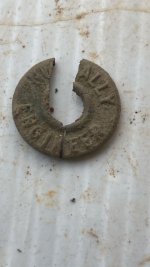
Yes Joe, but I didn't want to say that after reading it may be a rule violation. Mr Grover stuff I don't know about. I will check him out. In the picture just posted besides the heart it says something. Can anyone explain it? Thanks again guys
Sent from my SM-G900T using Tapatalk
Sent from my SM-G900T using Tapatalk