the priest map or witch map

Twisted Fork

Hero Member
Sep 2, 2007
723
52
UTAH
Detector(s) used
tf900 & a good old fashioned willow forked limb
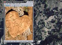
Each of the two heart stones that lead into the location of the mine, can be found any where a tunnel has been hidden. The one that you have so kindly shared with us is the large primary "Standing Heart Stone" #1. This tells one that he is just a stones throw from the Apex of the infield triangle the apex of which should be to the left of the heart on a small shelf or flat with a tree or bush and stone set up together on the ground. A trowel means smoothed over treasure; mud or concrete, and round stones relate to a bolder plugged entry.

To the right of this heart #1 should be two individual markers with a cache between them. Shoot your compass from the trowel stone, aiming between the spread of the two single markers and just beyond there should be the vein. Dore I might say, hidden on the surface, in the vein of which the tunnel runs through. A second cache will be to the left even further up the vein with markers likewise. To the right of the Dore cache and nearer to the concealed entry, one will find a beautiful small heart stone laying on the ground. The X is used to read all heart stones of all sizes as the center of attention if one is to find the mine. Knife to Heart..X..points one of the 4 directions. Keep in mind that what I have explained can be turned one of 4 ways as well; N.S.E.W.

The little red heart stone pictured above, was used by the Monks with an eyeglass and is the very individual stone that the carvings on the tablets were designed from. It is the foundation of the entire code, reveling the marker sequences and the location of every mine that was ever mapped. Same system over and over again like a chain and its links.
 

Last edited:

somehiker

Silver Member
May 1, 2007
4,365
6,426
Primary Interest:
All Treasure Hunting
Wow !
And here I was thinking it was something complicated.:icon_scratch:
 

Twisted Fork

Hero Member
Sep 2, 2007
723
52
UTAH
Detector(s) used
tf900 & a good old fashioned willow forked limb
The marker layout is based on the Italian's older world methods of laying tarot cards on the table. The marker layouts work like the paper maps: forward, backwards, upside down or turned around, depending on how the terrain requires.

You have found the hardest to find marker already. At that heart marker, one is able to stand and view the piece of ground section before you of which the gold vein runs through; Piece of cake from there, and beware of poisons in those caches sir.............
 

Last edited:

peralta

Sr. Member
Sep 28, 2011
389
45
oahu hawaii
Detector(s) used
Whites 2-box
Primary Interest:
All Treasure Hunting
Hello somehiker, you have a good heart, it's different. If you can zoom in check the the top curve of the heart, it looks like a tiny mine symbol.look at the shadows under the heart and lines in the heart it may be a map.take care my friend
 

somehiker

Silver Member
May 1, 2007
4,365
6,426
Primary Interest:
All Treasure Hunting
Hello somehiker, you have a good heart, it's different. If you can zoom in check the the top curve of the heart, it looks like a tiny mine symbol.look at the shadows under the heart and lines in the heart it may be a map.take care my friend

It's a good match for TF's stone heart...especially with the lump on the one lobe.
The diagonal crack across the other lobe matches that on the Stone Heart,which is a good indicator of it's relevance to the Stone Maps.The "X" and the sideways figure "8" also apply to what is shown on the Stone Maps.
I was pleased to find it.

Regards:SH
 

Twisted Fork

Hero Member
Sep 2, 2007
723
52
UTAH
Detector(s) used
tf900 & a good old fashioned willow forked limb
It's a good match for TF's stone heart...especially with the lump on the one lobe.
The diagonal crack across the other lobe matches that on the Stone Heart,which is a good indicator of it's relevance to the Stone Maps.The "X" and the sideways figure "8" also apply to what is shown on the Stone Maps.
I was pleased to find it.

Regards:SH

It would appear that this combination repeats itself where ever there is gold sign to be found. I have come to realize that this is the most accurate and probably oldest way in which to prospect.
The shapes really do appear on every scale from a mountain range down to the smallest grain of quartz.
 

peralta

Sr. Member
Sep 28, 2011
389
45
oahu hawaii
Detector(s) used
Whites 2-box
Primary Interest:
All Treasure Hunting
Hello my friends, you remember that you have to find the starting point. Its not in the superstitions or four peaks region ..hearts are good markings but don't count on finding large hearts to get you started or mark your path.it's true that all the markings of the stones are visible around you to see.the problem is you have to be patient and learn to see parts of the stones markings..first look at thelines of the terrain and match it with hills never assume that a marking is only going to be found by following others trails people are following.
 

cactusjumper

Gold Member
Dec 10, 2005
7,754
5,388
Arizona
Hello my friends, you remember that you have to find the starting point. Its not in the superstitions or four peaks region ..hearts are good markings but don't count on finding large hearts to get you started or mark your path.it's true that all the markings of the stones are visible around you to see.the problem is you have to be patient and learn to see parts of the stones markings..first look at thelines of the terrain and match it with hills never assume that a marking is only going to be found by following others trails people are following.

Peralta,

Most of the starting points have been published, and they end up in the Superstitions. Sounds like you are following someone else's trail.

If you start at the bottom of Hieroglyphic Canyon, the map is easy to follow. The bent arrow ends up on top of the ridge line of the main mountain. The dotted line takes you down into West Boulder. Those dots match every turn in the ravine going down into the canyon.

Good luck,

Joe
 

Ellie Baba

Hero Member
Mar 7, 2005
527
54
Laveen, AZ
Detector(s) used
Tesoro Lobo
Peralta,

Most of the starting points have been published, and they end up in the Superstitions. Sounds like you are following someone else's trail.

If you start at the bottom of Hieroglyphic Canyon, the map is easy to follow. The bent arrow ends up on top of the ridge line of the main mountain. The dotted line takes you down into West Boulder. Those dots match every turn in the ravine going down into the canyon.

Good luck,

Joe

Hi Joe,

Why would you start at the bottom of Hieroglyphic Canyon? What is it that brought you to this particular ridgeline? If this area truly represents the beginning of the trail how would anyone using the stone maps locate this particular spot?

I am just trying to understand why you would choose this canyon ridge when you know where the three largest man made hearts are located in the state of Arizona. You know, just north of the Gila River where Manje had made a comment** about being able to see Casa Grande with Father Kino's telescope*(he was just a tad more to the east than Heart Mnt.).

Interesting that when one is located at Casa Grande (on an exceptional clear day) you can see the two hearts located on Heart Mountain 24 miles away with an unobstructed view, Casa Grande's elevation is 1,423' and Heart Mountain's two hearts are at an elevation of 2,540'. Of course you would have to use a set of field glasses comparable to Father Kino's telescope.

The Hearts were designed to be seen from Casa Grande and this is where the trail starts. Father Kino was aware of this point (Casa Grande) as was Frey Marcos de Niza (see below) for they were both excellent Navigators and knew exactly where they were located.

One must have well known permanent landmarks to work with to find the trail. Everyone back in the day knew exactly where Chichiticale (Casa Grande) was located. Many of today's historians have botched that one up. A few actually have figured it out; Find and read an English version of this awesome well researched work. The Stone Maps require the three hearts and Casa Grande as they are the foundation of the beginning of the trail!
 

FRAY MARCOS DE NIZA: IN PURSUIT OF FRANCISCAN UTOPIA IN AMERICAS


BY MICHEL NALLINO

Kino’s Historic Memoir of Pimeria Alta: a contemporary account, Volume 3
by Eussebio Francisco Kino
Book IV, Chapter 1

That map which I brought with me to the Indies and even to these new conversions with its little treatise and instruction or explanation for it is cosmographical, geographical, horological and horographical, nautical and geometrical etc; page 330


Horology (from Greek: ὥρα, "hour, time" and Greek: λόγος, logos, "study, speech"; lit. the study of time) is the art or science of measuring time. Clocks, watches, clockwork, sundials, clepsydras, timers, time recorders and marine chronometers are all examples of instruments used to measure time.

Horography

  1. (n.) An account of the hours.
  2. (n.) The art of constructing instruments for making the hours, as clocks, watches, and dials. Kino had made two of these instruments before making his trip to California. One went to China with another Jesuit Brother.
cosmography
- 3 dictionary results cos·mog·ra·phy
cosmography / / [koz-mog-ruh-fee] –noun, plural -phies.
1. a science that describes and maps the main features of the heavens and the earth, including astronomy, geography, and geology.
2. a description or representation of the main features of the universe.
Origin:
1350–1400; ME < Gk kosmographía description of the world.
—Related forms
.0cos·mog·ra·pher, cos·mog·ra·phist, noun
cos·mo·graph·ic/ˌ [koz-muh-graf-ik]
cos·mo·graph·i·cal, adjective
cos·mo·graph·i·cal·ly, adverb

Kino’s Historic Memoir of Pimeria Alta: a contemporary account, Volume 3
by Eussebio Francisco Kino
Book IV, Chapter 1

But now already thanks to His Divine Majesty with various expeditions and three in particular of one hundred and fifty one hundred and seventy and two hundred leagues which I have made from here to the north of Nuestra Senora de los Dolores I have discovered with all minute certainty and evidence with mariner's compass and astrolabe in my hands that California is not an island but a peninsula or isthmus and that in thirty two degrees of latitude there is a passage by land to California and that only to about that point comes the head of the Sea of California the large volumed rivers which in the following chapters will be mentioned emptying into the head. Page 334
LATITUDE THIRTY ONE AND A HALF DEGREES At midday we took the altitude of the sun with the astrolabe and found it to be fifty two degrees which adding to it the six and a half of south declination of that day made fifty eight degrees and a half. The complement of ninety degrees is thirty one degrees and a half and this was the altitude of the pole or geographical latitude in which we found ourselves. 467


Chapter VIII

The casa grande is a four story building as large as a castle and equal to the largest church in these lands of Sonora It is said that the ancestors of Montezuma deserted and depopulated it and beset by the neighboring Apaches left for the east or Casas Grandes (a different group of ruins located farther to the southeast) and that from there they turned towards the south and southwest finally founding the great city and court of Mexico.
Close to this casa grande there are thirteen smaller houses somewhat more dilapidated and the ruins of many others which make it evident that in ancient times there had been a city here On this occasion and on later ones I have learned and heard and at times have seen that further to the east north and west there are seven or eight more of these large old houses and the ruins of whole cities with many broken metates and jars charcoal, etc. These certainly must be the Seven Cities mentioned by the holy man Fray Marcos de Niza who in his long pilgrimage came clear to the Bacapa rancheria of these coasts which is about sixty leagues southwest from this casa grande and about twenty leagues from the Sea of California. The guides or interpreters must have given his Reverence the information which he has in his book concerning these Seven Cities although certainly at that time and for a long while before they must have been deserted.
( 123 Bancroft's mistrust of the A fanes leads him here into needless error He states in North Mexican States and Texas vol i 259 that it is implied by the Afanes that Kino named these two rancherias But the Afanes clearly asserts this fact and does not merely imply it. I believe that the Favores is the only authority which identifies these rancherias with the native names. 129 On the Manuscripts of the Luz de Tierra Incognita there is a drawing of the Casa Grande presumably by Manje p 57 There is also one made in 1776 on one of the original diaries of Juan Bautista de Anza. Father Kino evidently had more knowledge of the Coronado expedition than Bancroft gives him credit for. North Mexican States and Texas vol i 259)

* Southwest Navigation Methods of Eusebio Francisco Kino, S. J. Author(s): Ronald L. Ives Source: Arizona and the West, Vol. 2, No. 3 ( Autumn, 1960), pp. 213-243Published by: Journal of the Southwest {Telescope mentioned on page 217 first paragraph and page 218 all of second paragraph}
**Father Kino's 1697 Entrada to the Casa Grande Ruin in Arizona: A Reconstruction Author(s): Ronald L. Ives Source: Arizona and the West, Vol. 15, No. 4 (Winter, 1973), pp. 345-370 Published by: Journal of the Southwest
Manje’s comment regarding Casa Grande, bottom paragraph page 357 and page 358 the first sentence.


Thanks in advance,

Ellie Baba
 

cactusjumper

Gold Member
Dec 10, 2005
7,754
5,388
Arizona
Ellie,

"Why would you start at the bottom of Hieroglyphic Canyon? What is it that brought you to this particular ridgeline? If this area truly represents the beginning of the trail how would anyone using the stone maps locate this particular spot?"

When I first saw the Stone Maps, I thought the line that many thought was the Salt River.....and other water courses, was a rough outline of the mountains from the south around Hog or Hieroglyphic Canyons. If that was true, the bent arrow was the trail they took into the mountains. Perhaps Bicknell's article pointed me in that direction.

Once I had that thought, it was child's play to lay out the entire map onto a topo'. All of the main canyons and some of the minor ones are on the Stone Maps. Many of the lines are trails through that portion of the range. Some are unknown to most of today's hikers. One is the trail that breaks off of the Dutchman's Trail on the north end of Black Top Mesa. Anyone know where that is on the Stone Maps? Anyone ever been on it? Any one know the history of what took place in that area?

The trail I laid out ends in Little Boulder Canyon. More importantly, it leads directly to the stone heart I have posted many times.

But then, what do I know?

Good luck,

Joe
 

Ellie Baba

Hero Member
Mar 7, 2005
527
54
Laveen, AZ
Detector(s) used
Tesoro Lobo
spelling

Ellie,

"Why would you start at the bottom of Hieroglyphic Canyon? What is it that brought you to this particular ridgeline? If this area truly represents the beginning of the trail how would anyone using the stone maps locate this particular spot?"

When I first saw the Stone Maps, I thought the line that many thought was the Salt River.....and other water courses, was a rough outline of the mountains from the south around Hog or Hieroglyphic Canyons. If that was true, the bent arrow was the trail they took into the mountains. Perhaps Bicknell's article pointed me in that direction.

Once I had that thought, it was child's play to lay out the entire map onto a topo'. All of the main canyons and some of the minor ones are on the Stone Maps. Many of the lines are trails through that portion of the range. Some are unknown to most of today's hikers. One is the trail that breaks off of the Dutchman's Trail on the north end of Black Top Mesa. Anyone know where that is on the Stone Maps? Anyone ever been on it? Any one know the history of what took place in that area?

The trail I laid out ends in Little Boulder Canyon. More importantly, it leads directly to the stone heart I have posted many times.

But then, what do I know?

Good luck,

Joe

Hi Joe,

For one who has been around these parts for many years I cannot remember ever having been on that trail, I am not aware of the history that had taken place in this area either. Please explain. By the way... what do you know? :icon_thumleft:


Ellie B
 

Last edited:

cactusjumper

Gold Member
Dec 10, 2005
7,754
5,388
Arizona
Ellie,

The trail we are talking about goes up the east (right) side of Hieroglyphic Canyon. Where the canyon takes a bend to the right, there is an old mine over on the west side of the canyon. You stay to the right until you are almost to the ridge line, and then cross over to the west side
to finish the climb.

I have been told that you can't ride a horse to the top anymore, but at one time it was possible. I know people who did it. In any case, it's a very difficult climb. It's not that far, but it should take you around 4-hours each way......moving right along.


The ridge is rich in history and legend. The body of a female Native American was said to have been found on the ridge. Senner's gold is in the area towards the west end. Harry LaFrance's cave of gold bars was on the north side of the ridge. If you follow Bicknell's instructions, you climb over the ridge and drop down into West Boulder, right where Adolph Ruth camped. As it happens, Bick camped at Willow Spring in 1886.


Tom Kollenborn states that Hieroglyphic Cyn. was called Apache Springs Canyon prior to 1930. Along with Harry LaFrance, my Uncle Chuck Ribaudo, Ernie Provence and Tracy Hawkins spent some time on the ridge together. It was obvious that Harry had spent a night up there on the trip when he found his cave of gold bars.


Take care,

Joe
 

peralta

Sr. Member
Sep 28, 2011
389
45
oahu hawaii
Detector(s) used
Whites 2-box
Primary Interest:
All Treasure Hunting
Hello my friend, input information on the discussion site.I won't be adding any more information there.you don't have to read it I was only trying to help on this subject. The map is deceiving, the the top line is really a hill that touches the peak.there is no river touching the large markings.hope you im not bothering, I wish that some that believe in this subject would come forward and back me up.
I know your heart is in it.if we could meet you can join me, i'll show you all the markings on my photos. Your welcome to join us and take your share of treasure.im not crazy and greedy.
Our partner in Mexico agreed with me on where they had moved the border site in the 1700.good luck.
 

Ellie Baba

Hero Member
Mar 7, 2005
527
54
Laveen, AZ
Detector(s) used
Tesoro Lobo
Hello my friend, input information on the discussion site.I won't be adding any more information there.you don't have to read it I was only trying to help on this subject. The map is deceiving, the the top line is really a hill that touches the peak.there is no river touching the large markings.hope you im not bothering, I wish that some that believe in this subject would come forward and back me up.
I know your heart is in it.if we could meet you can join me, i'll show you all the markings on my photos. Your welcome to join us and take your share of treasure.im not crazy and greedy.
Our partner in Mexico agreed with me on where they had moved the border site in the 1700.good luck.

Hi Peralta,

You are correct in saying that the maps are deceiving and on that point I am in agreement 100%. Let us take a logical look at your interpretation; "the top line is really a hill that touches the peak". So I will ask you how did you determine which hill this line represents and what peak does it touch? If the line is not to be identified as a river than how will we find the horse pasturing on the north side of the river? Would it be easier to identify a river or select a hill that touches a peak? There is literally thousands of hills out there that connect to thousands of peaks. You, Senor Peralta must be able to convince me, your reader. The information that one places on a site must be credible and or make sense to those of us who are trying to buy into your theories. Documentation relating to the information that you provide to this site must be convincing. Maybe those that buy into your theory would in fact support you. Listen to me Peralta; You are not bothering anyone so keep on posting anything you believe to be of importance. How else are we to learn from each other?

When it comes right down to it we all face the very same problem; who will back us up on our particular theories. The truth is quite simple to grasp; show us the treasure or the verifiable gold nuggets and that is basically all there is to it. I would be happy to meet with you or any of your compadres to share any information you may have or that I may have. I live here in the Phoenix area and you may contact me anytime. Glad to become acquainted with you and I am always happy to listen and learn.

Have a great weekend!

Ellie Baba
 

Twisted Fork

Hero Member
Sep 2, 2007
723
52
UTAH
Detector(s) used
tf900 & a good old fashioned willow forked limb
A simple reference in itself is simply to look into which area surrounding the tablets excavation site, holds the most gold and silver bearing minerals with the "RIO" running through it. The burro pastures along the "RIO" somewhere in a section where the river is evidently running North and South. Kind of helps in narrowing things down a little eh mateys? Soorry to say that the Damn Dam they built killed canyon Fresco as well as other sections of the terrain across the mountains which depended on what was a little moisture the bubbling springs provided. Once a sure give away to the mine and it's goodies.

Legends, as they are called alike, are like the tablets, are usually drawn in little boxes down at the bottom of the area of which the maps(s) pertain to sirs. Obviously the area of the heart is North West of Globe; along that one trail where they found the tablets at.

The view one seeks is just that; the concentration of one's wealth, underneath it all. The Heart.
 

peralta

Sr. Member
Sep 28, 2011
389
45
oahu hawaii
Detector(s) used
Whites 2-box
Primary Interest:
All Treasure Hunting
Hello ellie baba and twisted fork. Think of what I mentioned that the name of the treasure is the santa Maria. Its mission is across the border to the south.the other thing I had mentioned is that I haven't met just broken the codes of just the peralta. I found the locations of all the markings of the santa Maria map, the the latin heart stones, the stone crosses and found the locations to of the treasure of Guadalupe. Now they are all in one place. Remember that the Guadalupe also called the tumacacori is from the mission to the south toward nogales. Finding all these treasure sites was difficult but not as difficult as finding the mine entertainment. That took about three years.all of these treasures were the bank of the church.
All the peralta markings are accurate. I can see every marking on the stones. Some markings like the squiggly lines are difficult to see if you don't find the markings around them. I can also see so many other treasure marking locations that have religious statues. And carvings.
 

Twisted Fork

Hero Member
Sep 2, 2007
723
52
UTAH
Detector(s) used
tf900 & a good old fashioned willow forked limb
Where precious metals can be found in their richest forms, nature systematically repeats itself through and through from the scale of a miners glass up to the twists in the slopes. The common denominator that makes up the engine and the balanced choice of graphics used in the making of the Peralta tablets. However there is a heart site from where the spirit or beginning of the map and chain comes to life. That would be on the Salt, near to their excavation site.
 

peralta

Sr. Member
Sep 28, 2011
389
45
oahu hawaii
Detector(s) used
Whites 2-box
Primary Interest:
All Treasure Hunting
Hello twisted fork, I understand that it is difficult to think that the treasure could not be anywhere else, that it has to be near the location that the stones were burried. I wish you the best as well as all the hunters that continue to search. I wish I could tell where where they are hidden now but in the future pictures of the treasures and markings will be. Shown.
 

Twisted Fork

Hero Member
Sep 2, 2007
723
52
UTAH
Detector(s) used
tf900 & a good old fashioned willow forked limb
Hello twisted fork, I understand that it is difficult to think that the treasure could not be anywhere else, that it has to be near the location that the stones were burried. I wish you the best as well as all the hunters that continue to search. I wish I could tell where where they are hidden now but in the future pictures of the treasures and markings will be. Shown.

One could gnaw on this for a while......... Twisted Fork 2012-05-25_2107.jpg

Truly Jesuit in origin, more than just a legend here sir......

From Des Buttes, Arizona and then North to Kings Peak, Utah; Across from Battle Mountain, Nevada to the Rocky Mts. The gold is right where you find it for sure.
 

Last edited:

Top Member Reactions

Users who are viewing this thread

Latest Discussions

Top