The Peralta Stone Maps, Real Maps to Lost Gold Mines or Cruel Hoax?

Do you think the Peralta stone maps are genuine, or fake?


  • Total voters
    121

sailaway

Hero Member
Mar 2, 2014
623
815
Primary Interest:
All Treasure Hunting
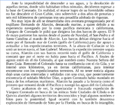
We know by written history the first to describe the Junction of the Colorado and Gila rivers was Hernando de Alarcon who was to re-provision Coronado on his land march.
First description of Colorado River and Gila.PNG
https://books.google.com/books?id=S...WAhVpiFQKHbfPBkQQ6AEIaTAL#v=onepage&q&f=false

How many of you read Spanish? anyone know the translation of the 1600 map?
Then also how did Coronado know where the Colorado and Gila were? There had to be previous knowledge or that would not have been set as a meeting point.
 

Last edited:

Matthew Roberts

Bronze Member
Apr 27, 2013
1,131
4,955
Paradise Valley, Arizona
Primary Interest:
All Treasure Hunting
Shame on you sdcfia - how dare you let facts get in the way of a good story. :)

Cubfan64,

Both the Arizona Historical Society at Tucson and the Arizona Department of Mining and Minerals hold the belief that the area near Jerome in Central Arizona was visited as early as 1582 by Spanish explorers looking for gold, silver and copper.
There is actually iron clad evidence cross checked by 120 years of official Spanish records that point to the fact Spanish Explorers indeed arrived near Jerome in 1582. Their exact route was never recorded by the explorers but what is known is their starting point and their returning destination.

What do you think of the recorded Spanish history of these events and of the Spanish inscription rock on the south east side of the South Mountains which is in the city of Phoenix today ?

Here is a short synopsis on the early Spanish exploration to the Jerome area :

In 1582 Diego Perez de Luxan, a Spanish explorer, recorded the first evidence of a Yavapai settlement. “This region,” wrote Luxan, “is inhabited by mountainous people, because it is a temperate land. During this night some of them came to our horses and fled when they heard them as they found the sound unfamiliar.” The next day the explorers came to a “rancheria” where the people who had fled had built a hut of branches.
Luxan describes bread made of mescal and pinon nuts. The Indians gave the Spanish explorers metals, silver and copper as a sign of peace and led them to the mines. The Spaniards considered the mine poor, as it was of mostly copper and not silver, so returned to their camp.

In 1583, Antonio de Espejo gives a differing account of metals found in the same location. He wrote, “I extracted the ore, said by those who know to be very rich and to contain much silver. The region where these mines are located is for the most part mountainous, as is also the road leading to them,” describing present day Jerome.

Farfan, who in 1598 was travelling with Juan de Onate, described the mines as an old shaft eighteen feet deep with brown, yellow, blue and green ores, “from which the Indians obtained the metals for daubing themselves and painting their blankets. The vein was very wide and rich and extended over many ridges, all containing ores. It extended along the hill that had been discovered, across from another hill opposite to it.”

The first mention of the Sierra Azul mine is in a memorial which stated that Penalesca (the governor of Sonora from 1661-1664) planned an expedition to Sierra del Azul, which was in today’s Verde Valley in Arizona.
The site of the Sierra Azul mine coincides in every way with the locale of the visits of the earlier Spanish explorers to the mines in the Verde Valley, close to present day Jerome.

In 1686 Posadas wrote that the Sierra Azul is 100 leagues southwest of Santa Fe and 50 north of Sonora. In 1691 Vargas checked reports on Sierra Azul while at El Paso and said that the Indians had not worked it very much, having merely dug out a cave-like pit. This would describe the same pit, some 16 feet deep that Farfan reported at the mines in 1598.

Mange, in 1699, stated that the Indians told him the Verde River was so named because it passed by a mountain containing veins of green, blue and other colored minerals.

In May 1744 Fray Carlos Delgado stated that, “This Sierra is called “Azul” because the land, rocks and the whole thing in fact is blue with green, red, yellow and purple veins. It runs from south to north, where it terminates in a flat, barren summit, on top of which is a stone two varas long and a vara and a half wide that is transparent and has the same luster as gold.”

Spanish explorers came to the Verde Valley from time to time, lured by the Sierra Azul. Aside from the brief recorded visits of Espejo, Farfan and Onate, between 1583 and 1605, the Yavapai had only occasional contact with the Spanish and later, the Mexicans.
 

Last edited:

Cubfan64

Silver Member
Feb 13, 2006
2,986
2,789
New Hampshire - USA
Detector(s) used
Fisher CZ21, Teknetics T2 & Minelab Sovereign GT
Primary Interest:
All Treasure Hunting
Cubfan64,

Both the Arizona Historical Society at Tucson and the Arizona Department of Mining and Minerals hold the belief that the area near Jerome in Central Arizona was visited as early as 1582 by Spanish explorers looking for gold, silver and copper.
There is actually iron clad evidence cross checked by 120 years of official Spanish records that point to the fact Spanish Explorers indeed arrived near Jerome in 1582. Their exact route was never recorded by the explorers but what is known is their starting point and their returning destination.

What do you think of the recorded Spanish history of these events and of the Spanish inscription rock on the south east side of the South Mountains which is in the city of Phoenix today ?

Here is a short synopsis on the early Spanish exploration to the Jerome area :

In 1582 Diego Perez de Luxan, a Spanish explorer, recorded the first evidence of a Yavapai settlement. “This region,” wrote Luxan, “is inhabited by mountainous people, because it is a temperate land. During this night some of them came to our horses and fled when they heard them as they found the sound unfamiliar.” The next day the explorers came to a “rancheria” where the people who had fled had built a hut of branches.
Luxan describes bread made of mescal and pinon nuts. The Indians gave the Spanish explorers metals, silver and copper as a sign of peace and led them to the mines. The Spaniards considered the mine poor, as it was of mostly copper and not silver, so returned to their camp.

In 1583, Antonio de Espejo gives a differing account of metals found in the same location. He wrote, “I extracted the ore, said by those who know to be very rich and to contain much silver. The region where these mines are located is for the most part mountainous, as is also the road leading to them,” describing present day Jerome.

Farfan, who in 1598 was travelling with Juan de Onate, described the mines as an old shaft eighteen feet deep with brown, yellow, blue and green ores, “from which the Indians obtained the metals for daubing themselves and painting their blankets. The vein was very wide and rich and extended over many ridges, all containing ores. It extended along the hill that had been discovered, across from another hill opposite to it.”

The first mention of the Sierra Azul mine is in a memorial which stated that Penalesca (the governor of Sonora from 1661-1664) planned an expedition to Sierra del Azul, which was in today’s Verde Valley in Arizona.
The site of the Sierra Azul mine coincides in every way with the locale of the visits of the earlier Spanish explorers to the mines in the Verde Valley, close to present day Jerome.

In 1686 Posadas wrote that the Sierra Azul is 100 leagues southwest of Santa Fe and 50 north of Sonora. In 1691 Vargas checked reports on Sierra Azul while at El Paso and said that the Indians had not worked it very much, having merely dug out a cave-like pit. This would describe the same pit, some 16 feet deep that Farfan reported at the mines in 1598.

Mange, in 1699, stated that the Indians told him the Verde River was so named because it passed by a mountain containing veins of green, blue and other colored minerals.

In May 1744 Fray Carlos Delgado stated that, “This Sierra is called “Azul” because the land, rocks and the whole thing in fact is blue with green, red, yellow and purple veins. It runs from south to north, where it terminates in a flat, barren summit, on top of which is a stone two varas long and a vara and a half wide that is transparent and has the same luster as gold.”

Spanish explorers came to the Verde Valley from time to time, lured by the Sierra Azul. Aside from the brief recorded visits of Espejo, Farfan and Onate, between 1583 and 1605, the Yavapai had only occasional contact with the Spanish and later, the Mexicans.

Hello Matthew - I haven't really done too much investigation into when the Spanish were in the area. It's an interesting topic, but I have too many interests and can't afford the time to dig into all of them in depth. My comment to sdcfia was only in response to his correction of Sailaway's "map" photo - that it wasn't a map but rather a well known rock inscription.
 

sailaway

Hero Member
Mar 2, 2014
623
815
Primary Interest:
All Treasure Hunting
Cortes was not discouraged in their attempts to exploration, despite this latest failure, and immediately began organizing a fourth expedition to the newly discovered lands. In front of it was the experienced captain Francisco de Ulloa, with instructions to go completely around the Island then considered California, as well as search for the missing Diego Hurtado de Mendoza.

The expedition consisted of three boats: St. Agatha, St. Thomas (probably led by Domingo del Castillo, who drew the map of the peninsula of Baja California) and Trinidad, the latter in command of Ulloa. They also were four Franciscans and Francisco de Terrazas as an observer.

The three ships departed on July 8, 1539 from Acapulco; however, at the height of the Marias Islands they faced a storm, so the ship St. Thomas left the group he needed repairs. The other two ships arrived in the bay of Santa Cruz on August 29, where they found the burned remains of the camp set up by Cortés. They then followed the planned route and crossed the Gulf of California to traverse along the coasts of Sinaloa and Sonora. On the tour, Ulloa landed on these shores some points, and on September 28 desmbocadura reached the Colorado River, where they landed on a sandbar and named the mouth of the "San Andrés Ancon" river. Here is an excerpt of the minutes of takeover is transcribed:

" ... the very magnificent Mr. Francisco de Ulloa, lieutenant governor and captain desta armed by the illustrious Marquis del Valle de Guajaca, took office in San Andrés ancón and vermilion sea, which is on the coast Desta New Spain hazia North, which is at height of thirty-three degrees and a half, ... putting his sword, in saying that if abía someone who contradicted him, he was ready to defend him, cutting her trees, tearing herbs, wagging stones from one part to another, and drawing water from the sea. all in sign of possession "

Once the takeover of the northern end of the Sea Bermeja, named after the reddish coloration of the waters stained with those from the Colorado River, they started back to Santa Cruz. 2 or 3 October arrived at the San Luis Gonzaga Bay, 6 to Bahia de los Angeles, and on October 19 they returned to Santa Cruz, where they continued to travel and turned Cabo San Lucas. On January 20, 1540 took possession of Cedros Island, after fighting hard against indigenous place. From here, Ulloa decides to send the information collected on the trip to Cortes, aboard the largest ship, the Santa Agueda, head of Preciado. Francisco de Ulloa, meanwhile, continues the journey with North course aboard the Trinidad, to get lost in the sea, without knowing more about him.

This was the last expedition sent Hernán Cortés to California. Although he never got the material rewards expected with these companies, Cortés enters again in history as the discoverer of Baja California. In addition, the Bermeja Sea, is now known as the Sea of ​​Cortez or Gulf of California and the "San Andrés Ancon" river now known as the Colorado River.
Xavier L?pez Medell?n: Exploraciones de Cort?s en el Mar del Sur
So Cortez himself led the expedition just before Alacron made his attempt on the Colorado river which at that time was named the "San Andrés Ancon" river.
Is the 33.5 degrees Ulloa made it to, the location of the Gila river?
 

Last edited:

JohnWhite

Bronze Member
Aug 20, 2017
1,524
1,402
Detector(s) used
Whites gmt
Primary Interest:
All Treasure Hunting
Xavier L?pez Medell?n: Exploraciones de Cort?s en el Mar del Sur
So Cortez himself led the expedition just before Alacron made his attempt on the Colorado river which at that time was named the "San Andrés Ancon" river.
Is the 33.5 degrees Ulloa made it to, the location of the Gila river?

I guess that Ulloa just vanished...And what of this Jesuit https://en.wikipedia.org/wiki/Jorge_Juan_y_Santacilia ??? Maybe I really have stumbled upon Don Jose's Tayopa...LOL
 

gollum

Gold Member
Jan 2, 2006
6,729
7,596
Arizona Vagrant
Detector(s) used
Minelab SD2200D (Modded)/ Whites GMT 24k / Fisher FX-3 / Fisher Gold Bug II / Fisher Gemini / Schiebel MIMID / Falcon MD-20
Primary Interest:
All Treasure Hunting
Cubfan64,

Both the Arizona Historical Society at Tucson and the Arizona Department of Mining and Minerals hold the belief that the area near Jerome in Central Arizona was visited as early as 1582 by Spanish explorers looking for gold, silver and copper.
There is actually iron clad evidence cross checked by 120 years of official Spanish records that point to the fact Spanish Explorers indeed arrived near Jerome in 1582. Their exact route was never recorded by the explorers but what is known is their starting point and their returning destination.

What do you think of the recorded Spanish history of these events and of the Spanish inscription rock on the south east side of the South Mountains which is in the city of Phoenix today ?

Here is a short synopsis on the early Spanish exploration to the Jerome area :

In 1582 Diego Perez de Luxan, a Spanish explorer, recorded the first evidence of a Yavapai settlement. “This region,” wrote Luxan, “is inhabited by mountainous people, because it is a temperate land. During this night some of them came to our horses and fled when they heard them as they found the sound unfamiliar.” The next day the explorers came to a “rancheria” where the people who had fled had built a hut of branches.
Luxan describes bread made of mescal and pinon nuts. The Indians gave the Spanish explorers metals, silver and copper as a sign of peace and led them to the mines. The Spaniards considered the mine poor, as it was of mostly copper and not silver, so returned to their camp.

In 1583, Antonio de Espejo gives a differing account of metals found in the same location. He wrote, “I extracted the ore, said by those who know to be very rich and to contain much silver. The region where these mines are located is for the most part mountainous, as is also the road leading to them,” describing present day Jerome.

Farfan, who in 1598 was travelling with Juan de Onate, described the mines as an old shaft eighteen feet deep with brown, yellow, blue and green ores, “from which the Indians obtained the metals for daubing themselves and painting their blankets. The vein was very wide and rich and extended over many ridges, all containing ores. It extended along the hill that had been discovered, across from another hill opposite to it.”

The first mention of the Sierra Azul mine is in a memorial which stated that Penalesca (the governor of Sonora from 1661-1664) planned an expedition to Sierra del Azul, which was in today’s Verde Valley in Arizona.
The site of the Sierra Azul mine coincides in every way with the locale of the visits of the earlier Spanish explorers to the mines in the Verde Valley, close to present day Jerome.

In 1686 Posadas wrote that the Sierra Azul is 100 leagues southwest of Santa Fe and 50 north of Sonora. In 1691 Vargas checked reports on Sierra Azul while at El Paso and said that the Indians had not worked it very much, having merely dug out a cave-like pit. This would describe the same pit, some 16 feet deep that Farfan reported at the mines in 1598.

Mange, in 1699, stated that the Indians told him the Verde River was so named because it passed by a mountain containing veins of green, blue and other colored minerals.

In May 1744 Fray Carlos Delgado stated that, “This Sierra is called “Azul” because the land, rocks and the whole thing in fact is blue with green, red, yellow and purple veins. It runs from south to north, where it terminates in a flat, barren summit, on top of which is a stone two varas long and a vara and a half wide that is transparent and has the same luster as gold.”

Spanish explorers came to the Verde Valley from time to time, lured by the Sierra Azul. Aside from the brief recorded visits of Espejo, Farfan and Onate, between 1583 and 1605, the Yavapai had only occasional contact with the Spanish and later, the Mexicans.

Hey Matthew,

I am over the mountains in Jerome at least once a week for work. Looking for anything in particular?

MIke
 

Last edited:

Cam M.

Tenderfoot
Sep 20, 2017
8
39
WA
Detector(s) used
Garrett AT pro/ Bounty hunter
Primary Interest:
All Treasure Hunting
Eatin popcorn while reading the debate. Keep it going!
 

sailaway

Hero Member
Mar 2, 2014
623
815
Primary Interest:
All Treasure Hunting
Mike being as your in the area maybe you could get a photo of the rock described by Fray Carlos Delgado as "transparent and has the same luster as gold”?
 

sailaway

Hero Member
Mar 2, 2014
623
815
Primary Interest:
All Treasure Hunting
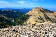
I have a problem with the Verde River and Jarome area as being the Sierra Azul. First a League is a Nautical measurement that works fine on a flat ocean and is based on speed of travel and uses the Nautical mile as a measurement to be able to plot distances on a map. A nautical mile is farther than a statute mile. Speed on a sailing ship is fairly constant and can be measured by a board attached to a line (rope) with knots tied in it equal distance apart. Throw the board overboard and count the knots that pass overboard in 1 minute. This is how the Leagues on a map were measured. Leagues on land were by how far you could walk in one hour. Walking in the mountains a person can not maintain 3 nautical miles a hour. The description of Sierra Azul from Santa Fe is 100 Leagues southwest. Anyone who has ever traveled US 60 across western New Mexico know it is fairly flat for the area and easy to travel. Walking from Santa Fe for 100 hours is a little over 2 weeks of walking if you use the 8 hours a day as fast as you could walk packing supplies. Even today I challenge anyone to make it to Jarome under those conditions. After putting Math and route conditions together I propose that the actual Sierra Azul is Mount Baldy the second highest peak in Arizona.
Mt.Baldy.jpg
 

nmth

Sr. Member
Oct 11, 2012
251
567
NM/AZ
Detector(s) used
V3(i), ATX, uMax, Gold Bug, TM808, Custom

Now you are trodding some new ground I've wandered a bit.

I think that there is a connection between the names Sierra Azul and Mogollon that needs to be established. Especially the pass of Mogollon (likely Not the semi ghost town location).

Look at the oldest of maps. There hangs Sierra Azul like a phantom, even when the whole map contains only a few names.

Prescott area, Flagstaff area, etc. are other candidates I see thrown around.

And your indicated candidate would pass right through Adams country, too.
 

sailaway

Hero Member
Mar 2, 2014
623
815
Primary Interest:
All Treasure Hunting
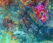
Morenci area by Nasa.
Nasa Moranci Az.jpg
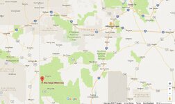
Photo made me wonder about the next mountain to the west of the Devils Highway. This is the same Chain of mountains with Mt. Baldy on the north end of the range within the San Carlos reservation. Blue river is to the East running up to the drainage of Mt. Baldy. Blue Range Wilderness in New Mexico is the Eastern side of the Blue River.
https://www.mininghistoryassociation.org/Morenci.htm
 

Last edited:

sailaway

Hero Member
Mar 2, 2014
623
815
Primary Interest:
All Treasure Hunting
Coronado Mountain west of Morenci. (blue mountain in upper NASA photo)
Serria Azul.jpg
 

audigger53

Hero Member
Mar 27, 2004
909
3,210
Severn, Maryland
Detector(s) used
None
Primary Interest:
Cache Hunting
I have a problem with the Verde River and Jarome area as being the Sierra Azul. First a League is a Nautical measurement that works fine on a flat ocean and is based on speed of travel and uses the Nautical mile as a measurement to be able to plot distances on a map. A nautical mile is farther than a statute mile. Speed on a sailing ship is fairly constant and can be measured by a board attached to a line (rope) with knots tied in it equal distance apart. Throw the board overboard and count the knots that pass overboard in 1 minute. This is how the Leagues on a map were measured. Leagues on land were by how far you could walk in one hour. Walking in the mountains a person can not maintain 3 nautical miles a hour. The description of Sierra Azul from Santa Fe is 100 Leagues southwest. Anyone who has ever traveled US 60 across western New Mexico know it is fairly flat for the area and easy to travel. Walking from Santa Fe for 100 hours is a little over 2 weeks of walking if you use the 8 hours a day as fast as you could walk packing supplies. Even today I challenge anyone to make it to Jarome under those conditions. After putting Math and route conditions together I propose that the actual Sierra Azul is Mount Baldy the second highest peak in Arizona.
View attachment 1498009
They would be using mules for the supplies, not backpacks. Just for the record, a nautical mile is 2,000 yards. From Navy Fire Control service.
Have you traveled Route 60? Not as flat as you would like when it drops off the rim from Showlow going to the Salt River Canyon. Wind Canyon is very impressive to look down into.
 

sailaway

Hero Member
Mar 2, 2014
623
815
Primary Interest:
All Treasure Hunting
Yes, I have traveled US 60 many times and have even traveled it in my Semi truck when hauling copper ingots from the mines. The drop off you describe is west of the area south to Mount Baldy and Coronado Mountain. Wind Canyon is tough to navigate in a semi truck even when empty. Wish I had paid more attention to the western mountains when waiting for loads while sitting on the rim of the Morenci mine. The blue of the area is copper ore, Azurite and Turquoise. Many examples of the minerals from the area can be seen in photos online. What I have found is livestock actually slows you down, yet easier than packing a load through the mountains. God forbid you have to cross a small stream, as lines do not exist in their world and they lock their legs.
 

audigger53

Hero Member
Mar 27, 2004
909
3,210
Severn, Maryland
Detector(s) used
None
Primary Interest:
Cache Hunting
Just curious, how did you get up to Rt 60 from Morenci? The road up the rim (the old Rt.666 to Alpine is closed for anything longer than 30 feet, those hairpins are nasty. LOL
 

sailaway

Hero Member
Mar 2, 2014
623
815
Primary Interest:
All Treasure Hunting
I did not take AZ 666 to US60 as semis are not allowed, but was referring to the mines of Miami/Globe/Ray area when on US 60. There is more than one copper mine in Arizona. My mention of US 60 being flat, I specifically stated in New Mexico and then you brought up Show Low, Arizona as not being flat, two different states. No idea as to why you thought I hauled only out of Morenci or just loaded out of one of the mines in Arizona or could even make it up a highway like 666. Only way out of Morenci mine with a loaded Semi is US 70 to I-10.
 

Last edited:

deducer

Bronze Member
Jan 7, 2014
2,281
4,360
Primary Interest:
Other
Getting way off subject here. The topic of this thread is: The Peralta Stone Maps, Real Maps to Lost Gold Mines or Cruel Hoax?
 

gollum

Gold Member
Jan 2, 2006
6,729
7,596
Arizona Vagrant
Detector(s) used
Minelab SD2200D (Modded)/ Whites GMT 24k / Fisher FX-3 / Fisher Gold Bug II / Fisher Gemini / Schiebel MIMID / Falcon MD-20
Primary Interest:
All Treasure Hunting
I have a problem with the Verde River and Jarome area as being the Sierra Azul. First a League is a Nautical measurement that works fine on a flat ocean and is based on speed of travel and uses the Nautical mile as a measurement to be able to plot distances on a map. A nautical mile is farther than a statute mile. Speed on a sailing ship is fairly constant and can be measured by a board attached to a line (rope) with knots tied in it equal distance apart. Throw the board overboard and count the knots that pass overboard in 1 minute. This is how the Leagues on a map were measured. Leagues on land were by how far you could walk in one hour. Walking in the mountains a person can not maintain 3 nautical miles a hour. The description of Sierra Azul from Santa Fe is 100 Leagues southwest. Anyone who has ever traveled US 60 across western New Mexico know it is fairly flat for the area and easy to travel. Walking from Santa Fe for 100 hours is a little over 2 weeks of walking if you use the 8 hours a day as fast as you could walk packing supplies. Even today I challenge anyone to make it to Jarome under those conditions. After putting Math and route conditions together I propose that the actual Sierra Azul is Mount Baldy the second highest peak in Arizona.
View attachment 1498009


Sailaway,

To the Spanish a land league was 2.18 miles.

Mike
 

Top Member Reactions

Users who are viewing this thread

Top