FOUR PEAKS

Quinan Bear

Sr. Member
Nov 7, 2008
312
6
Grande Prairie Alberta
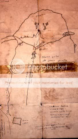
I will show you the "Y" in Waltz's Map. It is exactly like the one on the map. I will also say the the arrows are there to show you the way. The small black arrow is a faulse passage that has a dead end, The other, larger black arrow is the way that the canyon turns and that you shouldn't go that way, the large white arrow is the correct way to pass. Once you get to where the canyon turns, you will see an area that continues up the mountain, this is the way to go. Follow this passage till you reach the top, then go over and down the other side till you see the same outline as that on the map above the arrows. This is the square rock but you will not see the pointed end unless your above the rock. ( the outline is the front side of the rock and the square with the pointed end is the top of the rock). p281567225-2.jpg y.png The "Y" has the same rock formation above it as the map and the center rock is by itself in the center of the Y eventhough it looks like it part of the rest of the rocks.
 

Quinan Bear

Sr. Member
Nov 7, 2008
312
6
Grande Prairie Alberta
this mite sound crazy,its thinking out side the box some.
but
has anyone without looking at any maps.
sit down and with the 100+ clues, and just made a map from the clues alone.?

That is a possiblity but Why? Only if you were planning on selling the map, would it make sence to do that. Nobody would buy such a map these days. And it would take too much time in the mountains to find a place that you could use, that would not be a likely fit to the clues. Unless you were acually at the same place that the clues are trying to point you to. Then you wouldn't need the map, lol.

Then again, you could just make up a map with faulse markings and signs that would match all the clues, but then again....WHY?
 

Cubfan64

Silver Member
Feb 13, 2006
2,986
2,789
New Hampshire - USA
Detector(s) used
Fisher CZ21, Teknetics T2 & Minelab Sovereign GT
Primary Interest:
All Treasure Hunting
this mite sound crazy,its thinking out side the box some.
but
has anyone without looking at any maps.
sit down and with the 100+ clues, and just made a map from the clues alone.?

I know one fellow for sure who has spent a great deal of time putting together every clue he's been able to find, categorizing them and analyzing the sources, then ranking them in some way to try to determine which clues have the best chance of being "valid" clues. His hope was to try to draw a virtual image of Waltz's mine surroundings - much the same way many of us have done, but doing it in a more analytical manner. Not sure if he's planning to actually try to put together an actual physical map, but I think your question is certainly a valid way to think outside the box and I imagine that to one extent or another, some folks have done exactly what you have suggested.

One of the things I've seen over and over again is how folks will often "fit" the physical terrain (be it through feet on the ground, GE or other means) to whatever map they've determined is the RIGHT one. It's one of the reasons why so many different people claim they can "prove" where a map leads, and yet all of them are in different places in the mountains.
 

Cubfan64

Silver Member
Feb 13, 2006
2,986
2,789
New Hampshire - USA
Detector(s) used
Fisher CZ21, Teknetics T2 & Minelab Sovereign GT
Primary Interest:
All Treasure Hunting
QB - Can you provide some information on the source of "The Waltz Map" you posted earlier and that you are describing? I know there's MANY maps claimed to be to the Lost Dutchman and/or Peralta Mines in the mountains, and each one has a history around it - who made it, where and when it first appeared, etc... For you to believe it's an authentic map and leads to areas of minerals, you must know the history of the map enough to believe it's valid.
 

Quinan Bear

Sr. Member
Nov 7, 2008
312
6
Grande Prairie Alberta
QB - Can you provide some information on the source of "The Waltz Map" you posted earlier and that you are describing? I know there's MANY maps claimed to be to the Lost Dutchman and/or Peralta Mines in the mountains, and each one has a history around it - who made it, where and when it first appeared, etc... For you to believe it's an authentic map and leads to areas of minerals, you must know the history of the map enough to believe it's valid.


I have pics of most maps that claim to be the one leading to the lost mine. I'm not sure on the who, when or where of any of the maps i have. The same goes for the Peralta stone maps. I just look at the landscape from topographic, geological, radar and magnetic maps that i have , to see if there is a possibility of minerals being in that area. Then i use google to study the area. If the area has certain spots that match up on a map? I then take that map and look on google to see if the rest of the map can be seen on google for that area. This is how i found the mines that are on the stone maps.
This "Waltz map" has many things going for it, in the respect that it matches and has many markers that fit this area that i have recently found. I can also see tailings and old trails that one would use to get to certain places. It also has markers from the tales that the Apaches said of the mine. Things like the horse's head, the circle, cresent and triangle. And the fact that they said "from the top of the peak, you could see the entrance to the mine". You can also see the four peaks from this place and they do seem to line up somewhat.
 

Quinan Bear

Sr. Member
Nov 7, 2008
312
6
Grande Prairie Alberta
To be honest, the only maps that i have full faith in, are the Peralta stone maps. The others i just use "if" i find a place that i can see the map markers in. The Peralta stone maps have proven themselves to me by showing me that the priest map does have a buried mine in the place that it points to. The lower trail map points to a place that has tailings and a path to it, and if you follow the vein to the north you will come to a place that has recorded mines. and the others have similar atributes too.
I used the "Waltz map" to show certain markers because i didn't want to show the markers that one of the Peralta stone maps point to. I thought that if i did that, it would give away too much information and others would figure out where it was located.
 

Cubfan64

Silver Member
Feb 13, 2006
2,986
2,789
New Hampshire - USA
Detector(s) used
Fisher CZ21, Teknetics T2 & Minelab Sovereign GT
Primary Interest:
All Treasure Hunting
Fair enough - I couldn't recall seeing that specific map is all
 

Quinan Bear

Sr. Member
Nov 7, 2008
312
6
Grande Prairie Alberta
I have found 2 other maps that show the same place and because of this, I know that there has been others that have found at least a couple of the mines in that area. So now i wonder if there is anything left there for others to find? Or if there is still a few areas that gold can be found? I have to think about this now....

Here are 2 maps and 2 google pics, each with one spot shown on each map. three points.jpg waves.jpg treasm23.jpg treasm57.jpg
One is the three peaks that says "key to mine", the other shows the waves that has the mine at the lower end.
 

FEMF

Full Member
Sep 10, 2009
158
86
Hello Q Bear
The sleeping Lady map is real, but the other map is a bad copy of the Fish map.
Take care, be safe.
FEMF
 

cactusjumper

Gold Member
Dec 10, 2005
7,754
5,388
Arizona
This is a picture of Al Morrows map that he used in his search for treasure. It was taken in his camp, around 1968.

AlsMap.jpg


This is Al Morrow with Ernie Provence taking pictures:

scan0002.jpg


Joe Ribaudo
 

Quinan Bear

Sr. Member
Nov 7, 2008
312
6
Grande Prairie Alberta
Joe;
At first glance without knowing what is writen on the map. I would say that the area on the left is garden valley, the long diagram in the center would be the outline of a cliff to the right edge of garden valley, The oval with the cave looks like "dead woman's cave" and the peak below the two men would be Yellow peak. The trail that goes around the men appears to be boulder canyon. I will add a google pic with the listed areas to help you see what i see. I know that it is rough but you get the idea i'm sure.
This is just a guess at first glance. I did find a good location just north of yellow peak that seems to have a cave or cache. Did they find what they were looking for?
Garden.jpg i added this to show where i think the other mine is. This if they are mines? Al's map.jpg
OOOPS!! i put my circle in the wrong place in the second pic. it should be just down from there. You can see a clump of bushes/trees, that is the spot. The circle almost covers it.
 

Last edited:

coazon de oro

Bronze Member
May 7, 2010
1,623
3,858
texas
Primary Interest:
All Treasure Hunting
I read somewhere in this site that the ldm had been found and looted.

Howdy Johnmark,

And welcome to Treasurenet, your interest in the LDM shows that you are also one of Coronado's children. You will find that a lot of people have claimed to have found the mine, yet no one can prove it. Most will show an area where it is supposed to be covered, and use the excuse that they can't get a permit to dig for it. Others will show you an empty hole or shaft, and claim that it was the LDM, and has been worked out. None of these area's have overwhelming evidence of most of the well known clues.

Some make the claim because they want, or rather need recognition. Others have searched for too long, and don't want to be looked upon as fools. Others do it for the money, these are the ones writing new books about it.

The same is true about the Lost Adams Diggings. Just how many times can they find it? Some say the gold was not there anymore, others say they took it. Now they are saying the gold is still there. How many times can the gold be taken? Not as many times as people can lie about it that's for sure.

Wait till you see real evidence before you believe all these claims.

Homar
 

cactusjumper

Gold Member
Dec 10, 2005
7,754
5,388
Arizona
All,

I have posted this link a number of times, but it wouldn't hurt for those who think that most of the clues on "found" LDM sites are missing from the stories, to go back through the thread again. There are 49 pages of posts, but what I posted had little conjecture and a lot of fact.

To be sure, I'm pretty well convinced it's the LDM, but I know a lot more than I posted. What is in the thread is, obviously, the story that could be made public. Many Dutch Hunters know the who, what and why of what took place at the "Pit Mine". Few know who initially showed the "finders" the mine.

Good luck,

Joe Ribaudo
 

johnmark29020

Sr. Member
Oct 8, 2012
322
216
oklahoma
Primary Interest:
All Treasure Hunting
Catusjack

Thanks for the link. It cleared things up. Also thanks for the warm welcome. I know that in late to the hunt, but i havent had time before now. Its hard to know where to start.
I was looking at adolf ruths story. And i was wondering if the words in latin are some kind of place marker.
Any thoughts.
 

Top Member Reactions

Users who are viewing this thread

Top