this rock on lower devils creek and another on war fork east of McKee Kentucky are terrain code maps, not initials. what bothers me is that some of the carvings seem more like spanish land codes more than english or french. just a feeling.
see maps below, click to enlarge.
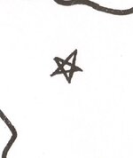
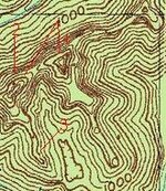
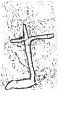
its a terrain code map. 1 points to dot which is a cave or rockhouse and it also points to where the cave or rockhouse is, in this case the miiddle of the S is a cliff with an S shape, number 3. 2 is an arrow that gives direction to go, once its found. lower part of the arrow points to a second rockhouse or cave, also points to left side of M. 4 shows that their are two caves or rockhouses near each other. 5 shows a flat ledge or path in front of both. 6 shows a ridge with two knobs high up with a sharp gap between. notice the left knob is lower than the right and the left has a sharper angle then the right, vary steep. 7 shows north direction and way to go. the 6 dots and SJM or saying 36 miles north to the location. i put the swift map star on here because it matches the SJM carving. at the S shaped cliff there is a small rockhouse, inside is an arrow carved from a flat rock that is sandstone and chipped to form the arrow and points west. on the west side of the gap at the knobs is a carving of a cross, could be a mine or showing a creek with a sharp left hand turn or a small valley. topo shows the two knobs and a rock vary high up with a gap between it and a large mountain. turkey track on rock points to knob gap.
see maps below, click to enlarge.
its a terrain code map. 1 points to dot which is a cave or rockhouse and it also points to where the cave or rockhouse is, in this case the miiddle of the S is a cliff with an S shape, number 3. 2 is an arrow that gives direction to go, once its found. lower part of the arrow points to a second rockhouse or cave, also points to left side of M. 4 shows that their are two caves or rockhouses near each other. 5 shows a flat ledge or path in front of both. 6 shows a ridge with two knobs high up with a sharp gap between. notice the left knob is lower than the right and the left has a sharper angle then the right, vary steep. 7 shows north direction and way to go. the 6 dots and SJM or saying 36 miles north to the location. i put the swift map star on here because it matches the SJM carving. at the S shaped cliff there is a small rockhouse, inside is an arrow carved from a flat rock that is sandstone and chipped to form the arrow and points west. on the west side of the gap at the knobs is a carving of a cross, could be a mine or showing a creek with a sharp left hand turn or a small valley. topo shows the two knobs and a rock vary high up with a gap between it and a large mountain. turkey track on rock points to knob gap.