accounting for the 1715 fleet vessels by their own " offical records"

billinstuart

Hero Member
Oct 17, 2004
578
11
stuart..the treasure coast..well, used to be
Detector(s) used
Minelab Excalibur with a WOT!
Primary Interest:
Beach & Shallow Water Hunting
Re: accounting for the 1715 fleet vessels by their own " offical records"

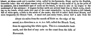
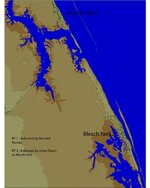
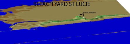
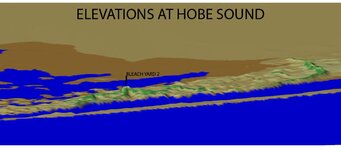
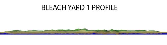
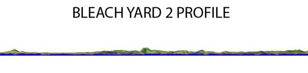
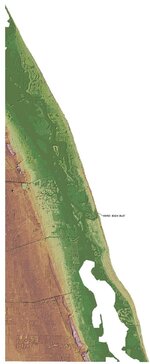
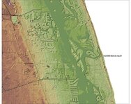
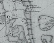
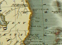
I've just found a few newer charts that show a "bleach yard" reference south towards jupiter inlet or SOUTH of it. since it's so crappy out, I've looked at a bunch of charts online. The only consistency is there is NO uniformity! Names of locations/inlets change. Rivers change. I've found a couple that show an inlet where Port Canaveral is. The "spring in rock" reference keeps showing up, somewhere around Jupiter. Is this "blowing rocks"?

BTW, I've saved all the crap I've found.
 

mad4wrecks

Bronze Member
Dec 20, 2004
2,263
107
Detector(s) used
Aquapulse, DetectorPro Headhunter, Fisher F75
Primary Interest:
Shipwrecks
Re: accounting for the 1715 fleet vessels by their own " offical records"

As I said earlier, the Spanish had a policy of geographical secrecy. They didn't share anything with the English. The English only ruled Florida from 1763 to 1784. This is when we start to see more discrepancies in many of the maps.

It would be interesting to see maps produced during Spain's second period of rule in Florida-and how they match up to earlier Spanish maps.

Bill makes a good point about an inlet near the Cape.....there was an inlet at one time in the Port Canaveral area. I will see if I can find my references to it.
 

Darren in NC

Silver Member
Apr 1, 2004
2,780
1,574
Detector(s) used
Tesoro Sand Shark, Homebuilt pulse loop
Primary Interest:
Shipwrecks
Re: accounting for the 1715 fleet vessels by their own " offical records"

Even though I've believed there's more than one Bleach Yard, I do believe the one Romans is referring to obviously is the one on his map. Even so, here's more accounts of the southern Bleach Yard west of Hobe Sound from early 1800's sailing handbooks...
 

Attachments

  • bleach.PNG
    bleach.PNG
    48.3 KB · Views: 763

mad4wrecks

Bronze Member
Dec 20, 2004
2,263
107
Detector(s) used
Aquapulse, DetectorPro Headhunter, Fisher F75
Primary Interest:
Shipwrecks
Re: accounting for the 1715 fleet vessels by their own " offical records"

good stuff Darren. :icon_thumright: What did the next page say????
 

billinstuart

Hero Member
Oct 17, 2004
578
11
stuart..the treasure coast..well, used to be
Detector(s) used
Minelab Excalibur with a WOT!
Primary Interest:
Beach & Shallow Water Hunting
Re: accounting for the 1715 fleet vessels by their own " offical records"

Grenville is Jupiter, which was south of its present location. Next is blowing rocks, at 1.5 leagues. "3 leagues" north of blowing rocks, and the only stretch of rocky beach in the area, is Gilberts Bar/House of Refuge. This is only a couple miles south of the generally accepted "Bleech Yard". Opposite Johnathan Dickinson Park, the site of the other potential "bleech yard", on the coast is Pecks Lake, a sandy stretch of beach.

Johnathan dickinson Park is only a mile or two north of Blowing Rocks.

Nonetheless, the "bleechyard" reference shows up from Boca to Ft. Pierce. Same for "los tortolas", the turtle hump hills.
 

GOHO

Sr. Member
Apr 13, 2008
299
35
Re: accounting for the 1715 fleet vessels by their own " offical records"

Our discussions inspired me to put together some visuals to try and understand what the early sailors would call the Bleach Yard. I wanted to know what they saw and how well it stood out as a land mark. I think this will shed a little light....


The first image is an overall view of the area in question. The other views are self explanatory. I used a 1/3" DEM from the USGS to create the surface and exaggerated the surface 10x.

Both areas have high hills that could be taken as the Bleach Yard but only one really stands out to me as the real landmark called "The Bleach Yard". Because of this thread i took a new look at something i took for gran-it before and i learned something out of it all. I believe the "REAL" Landmark called "The BLEACH YARD" is in Hobe Sound not St Lucie... Thanks Tom and everyone else that contributed!


Hope this info helps!!!
 

Attachments

  • BLEACH YARD DEM copy.jpg
    BLEACH YARD DEM copy.jpg
    138.7 KB · Views: 804
  • BLEACH YARD ST LUCIE copy.jpg
    BLEACH YARD ST LUCIE copy.jpg
    32.2 KB · Views: 779
  • BLEACH YARD HOBE SOUND copy.jpg
    BLEACH YARD HOBE SOUND copy.jpg
    62.5 KB · Views: 797
  • BLEACH YARD 1 SIDE PROFILE.jpg
    BLEACH YARD 1 SIDE PROFILE.jpg
    22.7 KB · Views: 738
  • BLEACH YARD 2 PROFILE.jpg
    BLEACH YARD 2 PROFILE.jpg
    21.9 KB · Views: 712

billinstuart

Hero Member
Oct 17, 2004
578
11
stuart..the treasure coast..well, used to be
Detector(s) used
Minelab Excalibur with a WOT!
Primary Interest:
Beach & Shallow Water Hunting
Re: accounting for the 1715 fleet vessels by their own " offical records"

"Los Tortolas" has the same confusing locations. I suspect the sailors used these visual references strictly as approximations of location. Relative to the entire length of the voyage from Havana to Spain, these two locations were the same. Romans has numerous discrepancies on his charts, either inadvertent or intentional. Since I live here, I know that the Hobe Sound hills are mostly tree covered, while the Jensen location once had a sheer side facing the ocean, devoid of vegetation.

BTW, the prominent hill in Hobe Sound is north of the park, and is the site of the water works.

Thanks GOHO for the depiction!
 

GOHO

Sr. Member
Apr 13, 2008
299
35
Re: accounting for the 1715 fleet vessels by their own " offical records"

I used a simular map here to try and find the places that are low where the ocean would breach if the sea water rose. I circled the areas that have the lowest points and would possibly be the old inlets. The resolution on this map is less than i wanted but to get a higer res required required to many downloads.....
 

Attachments

  • INLETS DEM.jpg
    INLETS DEM.jpg
    183.7 KB · Views: 891
OP
OP
ivan salis

ivan salis

Gold Member
Feb 5, 2007
16,794
3,809
callahan,fl
🏆 Honorable Mentions:
1
Detector(s) used
delta 4000 / ace 250 - used BH and many others too
Re: accounting for the 1715 fleet vessels by their own " offical records"

good work --clearly using the old noodle well --good thinking :hello2:
 

billinstuart

Hero Member
Oct 17, 2004
578
11
stuart..the treasure coast..well, used to be
Detector(s) used
Minelab Excalibur with a WOT!
Primary Interest:
Beach & Shallow Water Hunting
Re: accounting for the 1715 fleet vessels by their own " offical records"

GOHO: The circles you've depicted are interesting. The large one north of the present St. Lucie is exactly where Mother Nature wanted an inlet during the last hurricane. I strongly suspect this is also the site of a previous inlet. Other circles are locations of known historic inlets or locations where there was washover during the last storms.
 

GOHO

Sr. Member
Apr 13, 2008
299
35
Re: accounting for the 1715 fleet vessels by their own " offical records"

Here is my attempt at trying to find the Old Winter Beach Inlet. I downloaded a High Res 1/9 DEM from USGS.. They only had it for Indian River County, If you look at the coast and look for the lowest points they should indicate where an inlet had been before. Throughly studying IRC there is only one place that fits.... I Marked the Map below...
 

Attachments

  • WINTER BEACH INLET HI RES.jpg
    WINTER BEACH INLET HI RES.jpg
    200.2 KB · Views: 779
  • WINTER BEACH INLET.jpg
    WINTER BEACH INLET.jpg
    130.2 KB · Views: 830

billinstuart

Hero Member
Oct 17, 2004
578
11
stuart..the treasure coast..well, used to be
Detector(s) used
Minelab Excalibur with a WOT!
Primary Interest:
Beach & Shallow Water Hunting
Re: accounting for the 1715 fleet vessels by their own " offical records"

GOHO: There is a natural deep channel there, which leads to the lagoon. Once at the lagoon, there are islands which form a "delta". This would be expected..fast inflowing water would carry sand, which would fall out of suspension as the water velocity dropped when the channel widened. That's where I thought it should be.

A very similar situation occurs at the old Ft. Pierce inlet.
 

mad4wrecks

Bronze Member
Dec 20, 2004
2,263
107
Detector(s) used
Aquapulse, DetectorPro Headhunter, Fisher F75
Primary Interest:
Shipwrecks
Re: accounting for the 1715 fleet vessels by their own " offical records"

Very good work gentlemen. :sign13:

And that former inlet at Winter Beach was (imho) the inlet of the Ais or the barra de Ays and probably very close to the real of the Capitana.
 

Sorroque

Full Member
Jan 5, 2007
128
0
Canaberal de Ayzm
Detector(s) used
GMHCX3
Re: accounting for the 1715 fleet vessels by their own " offical records"

Hey!
I am posting the googlemap of the coordinates to where I found the "Pictograph" of the 'Treasure ship'.
Also some thoughts of my own.
Ship possibly buried onshore like another.
As you shall see from the coordinates the pictograph was found away from where you all have proof.
Could the treasure be nearby on beach on undeveloped land or on the island adjacent to the location of pictograph in river on developed land.
"Circle" in body of water. "Anchor" hoard of treasure.
You all decide. I have no posted posts of any finds. I am sorry that is unfair to everyone. But I have not found anything else but the symbol. I shall be sure to post them when I have made a treasure find, such as coins , gold, or jewelry.
Use the green arrow for marker once you have the cords googled .
McClarty Treasure Museum: 27.833894,-80.434017
Possible upraised mound of buried ship: 27.818793,-80.426611
Parking Area North of Nuestra Senhora de le Regle Reyes.: 27.822344,-80.428135
Beach location for Pictograph of the Senorha de le Regla de Reyes: 27.821172,-80.427134
I was listening to Jimmy Buffets song, "Trying to Reason with a Hurricane" 3x's while I did this google for you.
Date was January 12th., 1995 when the ROCK was found.
 

Darren in NC

Silver Member
Apr 1, 2004
2,780
1,574
Detector(s) used
Tesoro Sand Shark, Homebuilt pulse loop
Primary Interest:
Shipwrecks
Re: accounting for the 1715 fleet vessels by their own " offical records"

Very nicely done, Greg.

billinstuart said:
Romans has numerous discrepancies on his charts, either inadvertent or intentional.

I'd like to know your discrepancies for further study. I've heard this, too and it hasn't been very clear to me who had the "correct" design.

Since I live here, I know that the Hobe Sound hills are mostly tree covered, while the Jensen location once had a sheer side facing the ocean, devoid of vegetation.

You are correct, Bill - they are tree-covered...today. But the prominent hill that Greg (GOHO) depicts further south used to be known as Bald-Head Mount, which I suspect was called this since it didn't have the vegetation we see today. I also suspect that Romans' northern Bleach Yard also had less vegetation and was a popular spot for drying sails. As time went by, more sailors found the southern harbor a bit more safe than the St. Lucie and eventually the southern Bleach Yard became more popular. This is purely speculation on my part from reading the accounts chronologically, but it does fit.
 

Chagy

Bronze Member
Dec 20, 2005
2,226
121
Florida
Detector(s) used
JW Fishers Pulse 8X
Primary Interest:
Shipwrecks
Re: accounting for the 1715 fleet vessels by their own " offical records"

mad4wrecks said:
No one has ever found a ballast pile at the St Lucie inlet despite extensive searching.

I have a testimony of someone who was traveling on the Urca who states that they ran aground in the mouth of a river on a sandy bottom. If this opening, mouth or inlet is closed today the ballast pile of the Urca could very well be under the beach, dunes or even the road…. :read2: :wink: :-X :icon_salut: :icon_salut: :icon_salut:
 

FISHEYE

Bronze Member
Feb 27, 2004
2,333
400
lake mary florida
Detector(s) used
Chasing Dory ROV,Swellpro Splash 2 pro waterproof drone,Swellpro Spry+ wa,Wesmar SHD700SS Side Scan Sonar,U/W Mac 1 Turbo Aquasound by American Electronics,Fisher 1280x,Aquasound UW md,Aqua pulse AQ1B
Primary Interest:
All Treasure Hunting
Re: accounting for the 1715 fleet vessels by their own " offical records"

Here is a 1737 map of the east coast.You can see mosquito inlet at the top(now ponce inlet)the next inlet down R Ais would be near the current sebastian inlet.Next down is A S lucia(port st lucie)Next down is R Jube(now jupiter inlet).Next is lake worth.Next 2 would be boynton and ft lauderdale inlets.

This maps inlets are natural inlets.Notice theres no barrier islands on the map.The R ais inlet is near the current sebastian inlet as it has a river system in it.The current Ft pierce inlet has no river that goes inland but st lucie does as does jupiter inlet.

Chagy the urca has ballast stones all around it and its not at the mouth of a river.But notice which way the shank of the anchor is pointed.
 

Attachments

  • eastcoastinlets.jpg
    eastcoastinlets.jpg
    53.7 KB · Views: 806
  • Urca_Postion.jpg
    Urca_Postion.jpg
    70 KB · Views: 800

FISHEYE

Bronze Member
Feb 27, 2004
2,333
400
lake mary florida
Detector(s) used
Chasing Dory ROV,Swellpro Splash 2 pro waterproof drone,Swellpro Spry+ wa,Wesmar SHD700SS Side Scan Sonar,U/W Mac 1 Turbo Aquasound by American Electronics,Fisher 1280x,Aquasound UW md,Aqua pulse AQ1B
Primary Interest:
All Treasure Hunting
Re: accounting for the 1715 fleet vessels by their own " offical records"

Heres a map from 1806 that shows a dry inlet south of the jupiter inlet and a new inlet and a middle inlet most likely formed after large storms.
 

Attachments

  • dryNewMiddle_inlets.jpg
    dryNewMiddle_inlets.jpg
    40.2 KB · Views: 784

Chagy

Bronze Member
Dec 20, 2005
2,226
121
Florida
Detector(s) used
JW Fishers Pulse 8X
Primary Interest:
Shipwrecks
Re: accounting for the 1715 fleet vessels by their own " offical records"

Good morning Gentleman,

John (Fisheye) Let me start by saying that I don’t believe that the Pepper park wreck is the Urca…there is many evidence to prove it and I’m sure that those who have done their homework will agree with me. How ever I’m not done with my research so my participation on this thread is limited….As far as the openings (inlets) I have several maps from the late 1600’s and early 1700’s and they all show different and many inlets that create many islands…I even have one that shows “Rio Nuevo” which means new river but I believe that the winner is a very rare map hand written which shows only 2 inlets and in the south one it even has little anchors in the intercostals which means a good spot to anchor and the anchors are really close to bleach yard. If you have only 2 inlets this creates just one island…In one of Salmon’s letter to the king he mentions that 9 vessels wrecked in the same island…..

How ever this is just my humble opinion…I have enjoyed this thread very much. Just got to love seeing Greg, my buddy Terry A. and my brother Tommy G. sharing information……Great work guys!!!!!

All the best,

Chagy……
 

mad4wrecks

Bronze Member
Dec 20, 2004
2,263
107
Detector(s) used
Aquapulse, DetectorPro Headhunter, Fisher F75
Primary Interest:
Shipwrecks
Re: accounting for the 1715 fleet vessels by their own " offical records"

John: unfortunately, the anchor at the Pepper Park site is not one of the originals from that wreck. I believe Art Hartman donated that anchor to the state of Florida, which he recovered from another 1715 wreck site. And of course, all the cannons on that site are concrete replicas. ::)

Luis, it is good to hear from you again my friend and see you contributing to this board once more.

"Tommy G"
 

Top Member Reactions

Users who are viewing this thread

Top