accounting for the 1715 fleet vessels by their own " offical records"

GOHO

Sr. Member
Apr 13, 2008
299
35
Re: accounting for the 1715 fleet vessels by their own " offical records"

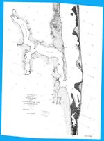
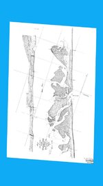
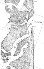
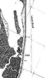
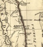
Yes, the old St Lucie Inlet fell between Lat 27: 9 and 27: 8, behind Leach Shoal. This Shoal created sort of a harbour. Now days the errosion south of present day St Lucie has created a new beach almost 1000' west from where it was in Bernard Romans times.... I know that in the 1960's a large inlet opened at pecks lake but by that time the new inlet was opened at 27: 10.
 

GOHO

Sr. Member
Apr 13, 2008
299
35
Re: accounting for the 1715 fleet vessels by their own " offical records"

Here is a detailed chart of St Lucie Area in 1883... I have this chart in Hi Res and georeferenced if anyone is interested in purchase... $25.00..
 

Attachments

  • 1883 GEOTIFF CHART.jpg
    1883 GEOTIFF CHART.jpg
    80.7 KB · Views: 955

GOHO

Sr. Member
Apr 13, 2008
299
35
Re: accounting for the 1715 fleet vessels by their own " offical records"

Here is a chart from 1861 of Indian River Inlet... This chart was made 100 years after Bernard Romans and the Inlet is still exactly the way he discribed it....
 

Attachments

  • 1861 INDIANRIVER INLET CHART copy.jpg
    1861 INDIANRIVER INLET CHART copy.jpg
    80 KB · Views: 663

GOHO

Sr. Member
Apr 13, 2008
299
35
Re: accounting for the 1715 fleet vessels by their own " offical records"

Here i zoomed in on the inlets...
 

Attachments

  • 1861 INDIANRIVER INLET CHART ZOOM.jpg
    1861 INDIANRIVER INLET CHART ZOOM.jpg
    284 KB · Views: 641
  • 1883 GEOTIFF CHART ZOOM.jpg
    1883 GEOTIFF CHART ZOOM.jpg
    48.1 KB · Views: 563

GOHO

Sr. Member
Apr 13, 2008
299
35
Re: accounting for the 1715 fleet vessels by their own " offical records"

As you can see on the St Lucie Chart that the Inlet was closed in 1883....
 

itmaiden

Hero Member
Sep 28, 2005
575
7
Re: accounting for the 1715 fleet vessels by their own " offical records"

umm. Thanks. I had read the account a long time ago, but forgot some of the details. So now I am thinking a particular ship is perhaps 1600's or 1500's. It is well camouflaged on the reef.

itmaiden


GOHO said:
This is an account of Lima.....


19 Oct 1715 - Havana, Don Miguel de Lima y Melo to Viceroy of Mexico.

"...All of the ships, with the exception of mine, broke to pieces. My ship stayed intact for 30 days after this disaster until we recovered part of the cargo and then burned the ship."
 

itmaiden

Hero Member
Sep 28, 2005
575
7
Re: accounting for the 1715 fleet vessels by their own " offical records"

Wow, that really changes one's view. Definitely worth keeping in one's collection. Looks like you have a good personal library.

itmaiden


GOHO said:
Here is a detailed chart of St Lucie Area in 1883... I have this chart in Hi Res and georeferenced if anyone is interested in purchase... $25.00..
 

GOHO

Sr. Member
Apr 13, 2008
299
35
Re: accounting for the 1715 fleet vessels by their own " offical records"

Thanks, I have dedicated the last 17 years to studying the 1715 fleet.....
 

signumops

Hero Member
Feb 28, 2007
756
226
U.S.
Detector(s) used
Garrett, Minelab, Aqua-Pulse
Primary Interest:
All Treasure Hunting
Re: accounting for the 1715 fleet vessels by their own " offical records"

I tend to agree with Greg on the location of inlets, BUT, the archaeological reviewer that Tom speaks of is interesting to say the least, especially in view of the following.

I am sorry, Tom, that I did not make the presentation on the 23rd... your gain, my loss. However, throwing DeBrahm's name around in support of a mystery inlet does not hold water (pardon the pun). Perhaps the presenter was relying upon Dr. De Vorsey's research footnotes reference "DeBrahm's Report Of The General Survey In The Southern District Of North America". In that volume, as well as DeBrahm's "Atlantic Pilot", DeBrahm charts "Hillsborough Inlet". That would be the old Indian River Inlet, however, Dr. De Vorsey says in his footnotes...

DeBrahmHillboroughInletNote.gif

De Vorsey is all wet. Here is a chart of Hillsborough Inlet surveyed by DeBrahm in 1765.

DeBrahmHillboroughInlet.gif

If you examine the mapnotes at the top, they place Hillsborough Inlet at...

DeBrahmHillboroughInletZoomCartouche.gif

Yep, 27 degrees, 30 minutes, 53 seconds, to wit: old Indian River Inlet. Definitely NOT just to the south of Melbourne Beach. So, what exactly was De Vorsey thinking? Well maybe he confused the DeBrahm map with the U.S. Survey map of Brevard County done in 1885. This will make your teeth grind! Look closely at next illustration, which is a zoomed out-take from that map.

1885GibsonCut.gif

Sebastian Inlet is then Gibson's Cut (which presaged New's Cut). I see an inlet north of Micco. That would be approximately in the vicinity of present-day Money Walk-Chuck's Steakhouse area! Could it be that the money at Chuck's comes from the Urca De Lima ? :o
 

Goldminer

Full Member
Apr 28, 2006
210
107
Las Vegas, Nv
Re: accounting for the 1715 fleet vessels by their own " offical records"

Terry,
My att'y had a beach house very near Chuck's, with a large lot attached to his property. Mel came there in the 1980's, and told him that he believed that there could have been a salvage camp on his vacant lot. Henry Taylor and I stayed at the beach house when we were in that area, and were told that many pieces of gold jewelry had been found two houses down.
 

itmaiden

Hero Member
Sep 28, 2005
575
7
Re: accounting for the 1715 fleet vessels by their own " offical records"

Well it's been a great thread. However, it's gotten so long, it's hard to load.
iltmaiden


mad4wrecks said:
And to think, if I hadn't of opened my mouth, none of this information would have come forth. :headbang: ;D
 

GOHO

Sr. Member
Apr 13, 2008
299
35
Re: accounting for the 1715 fleet vessels by their own " offical records"

Terry, The DeBrahm chart is interesting... I will trade you a hi res copy of any of my charts geo referenced to any corrdinate system you like for a Hi Res copy of your chart? I have the Atlantic pilot but the charts that come with it are not that detailed....

Thanks for posting....
 

OP
OP
ivan salis

ivan salis

Gold Member
Feb 5, 2007
16,794
3,809
callahan,fl
🏆 Honorable Mentions:
1
Detector(s) used
delta 4000 / ace 250 - used BH and many others too
Re: accounting for the 1715 fleet vessels by their own " offical records"

once again I want to thanks folks for their honest exchange of information related to this matter --this is how we all learn --
 

mad4wrecks

Bronze Member
Dec 20, 2004
2,263
107
Detector(s) used
Aquapulse, DetectorPro Headhunter, Fisher F75
Primary Interest:
Shipwrecks
Re: accounting for the 1715 fleet vessels by their own " offical records"

The Spanish had a policy of geographical secrecy. Rest assured, they did not provide any information to the English when the Brits took over rule of Florida. As for the Brits, much of their surveying/estimating/calculating was pretty inaccurate. (Wasn't it Romans who depicted Merritt Island extending all the way down to the Sebastian River?)

During Menendez (1565) the Barra de Ays was open. During Mexia (1605), still open. During Dickinson (1696) still open. During 1715 fleet disaster, still open. But when DeBrahm got here (1773?) the "Barra de Ays" at Indian River Shores was closed up. Not knowing that an inlet even existed at the Indian River Shores location, DeBrahm assigned that identity, "Barra de Ays" to the old Indian River Inlet down near Ft Pierce-the closest one around.

All of the geographical features you see in the Indian River at Indian River Shores/Winter Beach, are due to the fact that an inlet once existed there. The science, barrier Island geomorphology, is pretty interesting.

Here is more confusion: William Roberts, in his History of Florida (London, 1763 p.22) mentions (quote) the "Rio de Ays, three leagues north of Rio Santa Cruz," which he also calls Santa Lucia on the same page, "and in latitude 27 deg. 45 min."

Now, assuming (incorrectly I believe) that Roberts is talking about the St. Lucie River, from there north to the old Indian River inlet is about 25 miles. This distance is way to far to be considered 3 leagues. Also, the old Indian River Inlet is at latitude 27.30

However the latitude mentioned, 27 deg. 45 min. is very close to Winter Beach and the site of the proposed "Barra de Ayz.", which about 12 miles north (close to 3 leagues) from the old Indian River Inlet!

So Roberts is either way off in both his latitude measurement and distance estimates...or he has simply confused place names yet his calculations are pretty darn accurate

Just more food for thought.

Also, I have numerous references for Santa Lucia being at/the old Indian River inlet (not the current St Lucie inlet) which I will provide later.

ps. Thanks to AE Brech for much of the information I am using.

Tom
 

billinstuart

Hero Member
Oct 17, 2004
578
11
stuart..the treasure coast..well, used to be
Detector(s) used
Minelab Excalibur with a WOT!
Primary Interest:
Beach & Shallow Water Hunting
Re: accounting for the 1715 fleet vessels by their own " offical records"

The last hurricanes have shown how new inlets can be formed under extreme conditions. My feeling is anywhere the barrier is narrow or low is a potential inlet, or has been in the past. Since the current is very low in the Indian River lagoon, it's unlikely it has changed much in the last few hundred years. This can be verified by the charts for the last few hundred years.

So the dune line is high, you say? Remember dunes are comprised of wind blown sand, which has to be fine to be moved by the wind. These dunes are fragile, and easily eroded or even blown away under the right conditions. Once the dune line is removed, any low area along the barrier island could be a potential inlet.
 

itmaiden

Hero Member
Sep 28, 2005
575
7
Re: accounting for the 1715 fleet vessels by their own " offical records"

A number of old maps I have looked at have been consistent with the location of St Lucie. But in the early days and with new explorers using old maps that were less detailed, it is very possible a number of explorers mis-understood where things were at. And how about the difference there between true north and magnetic north.

An interesting detail I found in an historical writing was "why" the "Bleach Yard" was so called. Many assume it was named that because of the drying of sails. However, the reference I read said the Bleach Yard was a "hill dotted with white spots" (not verbatim) thus "bleach yard".

itmaiden


mad4wrecks said:
Here is more confusion: William Roberts, in his History of Florida (London, 1763 p.22) mentions (quote) the "Rio de Ays, three leagues north of Rio Santa Cruz," which he also calls Santa Lucia on the same page, "and in latitude 27 deg. 45 min."

for Santa Lucia being at/the old Indian River inlet (not the current St Lucie inlet) which I will provide later.

Tom
 

billinstuart

Hero Member
Oct 17, 2004
578
11
stuart..the treasure coast..well, used to be
Detector(s) used
Minelab Excalibur with a WOT!
Primary Interest:
Beach & Shallow Water Hunting
Re: accounting for the 1715 fleet vessels by their own " offical records"

I agree with the sail drying analogy. Just like "Los Tortolas" at Ft. Pierce 'looked" like turtle humps, the "Bleech yard" looked like a drying area. There was NO deepwater access to that area, and the Spanish had JUST left Havana..why dry their sails so soon?
 

GOHO

Sr. Member
Apr 13, 2008
299
35
Re: accounting for the 1715 fleet vessels by their own " offical records"

Here is an interesting chart by Bernard Romans but he has the name of St Lucie Inlet as Ays Inlet...
 

Attachments

  • Bernard Romans 1776.jpg
    Bernard Romans 1776.jpg
    210 KB · Views: 554

billinstuart

Hero Member
Oct 17, 2004
578
11
stuart..the treasure coast..well, used to be
Detector(s) used
Minelab Excalibur with a WOT!
Primary Interest:
Beach & Shallow Water Hunting
Re: accounting for the 1715 fleet vessels by their own " offical records"

GOHO, that's EXACTLY one of the maps that i've looked at very carefully. Hillsboro has to be Ft. Pierce. "AYS Inlet" appears to be slightly north of the present location, about where mother nature tried to open one during the last hurricane. Notice how he shows foul areas just offshore from the mouth..where the reef is.
 

Top Member Reactions

Users who are viewing this thread

Latest Discussions

Top